West Fork of Oak Creek
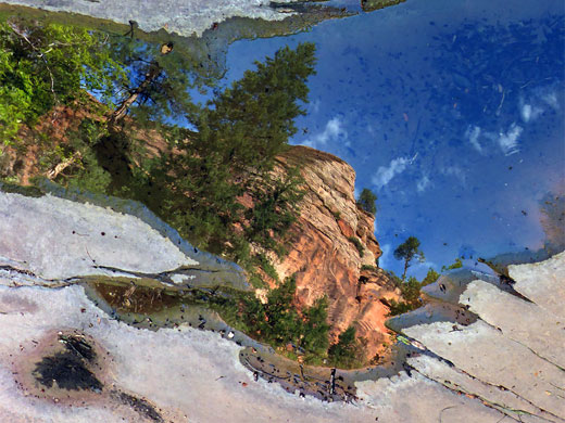
Deep, forested canyon with red rock cliffs and other eroded formations, enclosing a permanent stream that forms numerous cascades and pretty pools. A trail follows the first 3 miles, while the remainder of the canyon can be seen by a combination of wading pools and walking on benches or slickrock beside the creek
Length: 5.7 miles to Barney Spring Canyon, 6.3 miles to the last red rock passageway, 9.7 miles to Casner Cabin Draw, 11.7 miles to the upper trailhead
Difficulty: Moderate, for the red rock section - pools to wade, boulders and fallen trees to pass. More difficult all the way to the upper trailhead, since a couple of places require swimming of deeper pools
Management: USFS - part of Coconino National Forest
Rocks: Coconino sandstone
Season: Summer and fall - when water levels are low
Trailhead: Large parking area on the west side of US 89A. Also accessible from the upper end, along FR131
Rating (1-5): ★★★★★

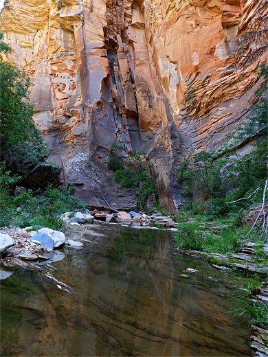
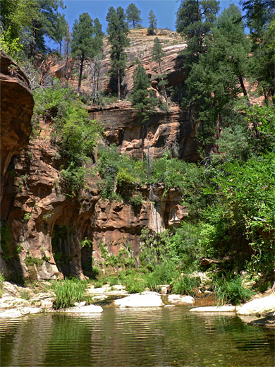
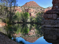
The 3.1 mile path along the lower reaches of the deep canyon of the West Fork of Oak Creek is generally considered the best trail in the Sedona region owing to the beautiful red rock scenery, the abundant wildflowers in spring and summer, and the many pretty pools and cascades along the creek.
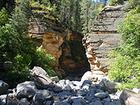
The hike is popular all year even in the depths of winter when some of the pools freeze and the canyon sides are enveloped with snow, though at any time not so many people continue beyond the official trail - after crossing the creek 13 times, and otherwise running across wide, usually wooded benches either side of the streamway, this ends after a descent from a higher bench in front of a pebble beach just before the first of many places where the stream covers all of the canyon floor, confined between low, red cliffs.
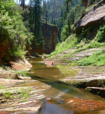
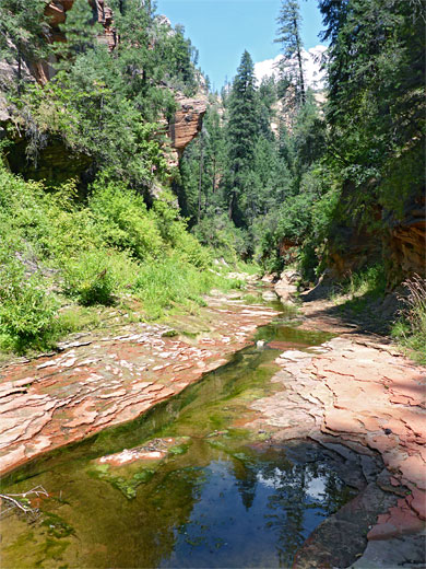
This particular obstacle can be avoided, if desired, by scrambling up the overgrown slope to the right, but ahead are numerous other places where wading is required, through clear water usually no more than two feet deep and often just a few inches. From trail's end, the canyon is next accessible by a road after 8.6 miles, via a track (FR 231) through the Kaibab National Forest, from Rogers Lake, and the whole distance could be hiked in one day, preferably using a car shuttle, with an alternative exit via Casner Cabin Draw, a deep tributary to the north. The upper reaches of the West Fork though are rather less scenic than the downstream section since the canyon sides sloping rather than sheer, the streambed is more overgrown and boulder-filled, the creek is more likely to be dry, and the rocks around the streambed are grey rather than red.
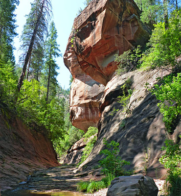
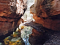
Instead, for an easier day hike, one target is the last major red rock pool and confined passageway, 3.2 miles from the end of the trail, this approximately the last place where the Hermit shale is exposed; the richly-colored red strata that forms all of the downstream canyon at creek level. Above, most of the walls are greyish-brown Coconino sandstone, overlain towards the top by white Kaibab limestone.
Topographic map of the West Fork of Oak Creek.
69 views of the West Fork of Oak Creek.
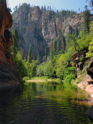
The West Fork joins the main Oak Creek canyon near its north end, about 6 miles south of the point where highway US 89 descends from the flattish, densely-forested land that extends south from Flagstaff into the red rock country around Sedona. US 89 is narrow, winding and offers only a few places to park at the roadside so most visitors to the West Fork are obliged to pay $12 per vehicle (2024) to use the official carpark/picnic area at the trailhead, Call of the Canyon. This has around 100 spaces, including a few sites reserved for RVs, though can be full by 10 am on busy times of the year, especially during spring and the fall color season.
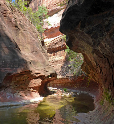
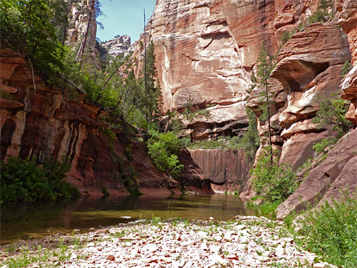
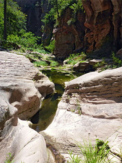
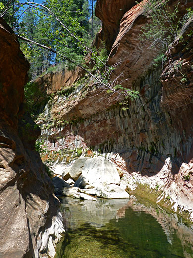
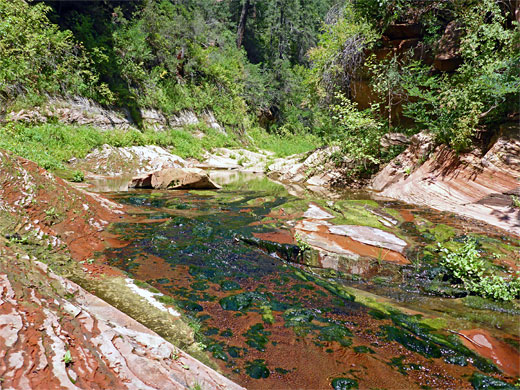
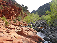
From the car park, the path crosses a meadow, runs alongside Oak Creek briefly, through a corridor of trees then passes over the stream on a high bridge, into another meadow, site of the ruins of Mayhew Lodge, which operated as guest accommodation until 1968. The official West Fork Trail begins just beyond, entering the canyon and following the creek for nearly 3 miles before descending to the pebble beach in front of a long pool, framed by eroded, subway-like cliffs. A notice warns backpackers that camping is not permissible until after another 2.7 miles. The pool is relatively shallow, usually just one foot or so, and extends for 400 feet, round a wide bend, then gives way to a sequence of smaller pools and boulders, at one point overlooked by a huge, streaked, overhanging, head-shaped rock formation. The streamway then becomes bushier, and less enclosed, as it curves through a U-shaped bend and heads north towards the next pretty section, another subway-like like passage below vertical, blackish walls, with a lengthy pool beneath. Not far beyond is a tributary on the south, originating on the slopes beneath Buckhead Point. The lower end is overgrown, usually dry, and does not look particularly interesting. Past the confluence is another wading pool and a bushy section; a long, straight, now heading northwest, about one mile from the end of the trail.
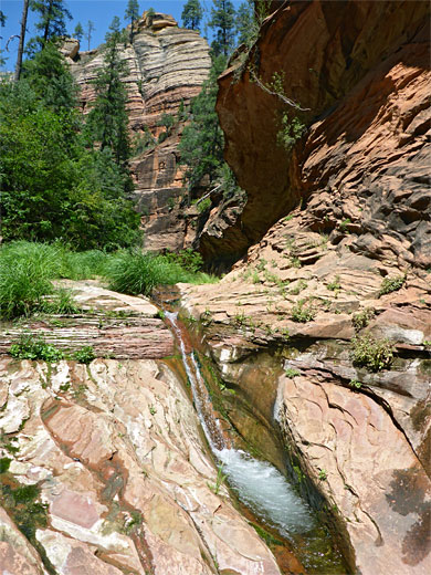
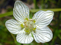
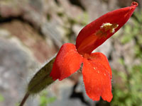
The canyon rounds a bend, below a photogenic, streaked cliff, near a good wildflower location that includes four bright red species growing close together (cardinal flower, california fuchsia, scarlet cinquefoil and washington monkeyflower), and continues with a lengthy section of trickling shallows over slickrock. A deeper pool is followed by a dark channel, a series of boulders, and another narrow, deep pool, passed by walking along a shelf on the left side. After more boulders, pools and cascades, the canyon bends to the left (north) and becomes wider and bushier once more, on to a section with deep red rocks below an overhanging cliff. A steep tributary joins from the southwest as the canyon angles back to the north, running through more nice passages lined with many green-flowered bog orchids in midsummer. A long straight, now 2 miles from the end of the trail, leads to a temporarily less distinctive section, before the widest pool, also quite long, and at its narrowest point 6 feet or more deep, though passable via a shallower wade along a slippery, submerged shelf.
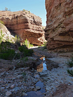
Next is a pretty bend and another bushy, tree-lined section, at one point bordered by a big sandy overhang, on the right side, used (illegally) for primitive camping, with litter, graffiti on the walls, and remains of fires at its base. The canyon floor widens around the junction with Barney Spring Canyon, soon followed by a smaller tributary, also on the west side. The bushy narrows lead to a some algae-covered pools and past an east-side tributary originating beneath Harding Point, this about 3 miles from the end of the trail. Some smaller, steeply-descending ravines join from the east as the cliffs above become somewhat less sheer, and the canyon more generally overgrown, as the red Hermit shale around the creekbed is replaced by the greyish Coconino sandstone. Rockfalls and downed trees are frequent, slowing progress. The gorge bends to the west and thereafter stays largely free of big pools or confined sections, apart from a narrow, flooded stretch after 4.8 miles and a few more deep pools around a narrow bend after 6.1 miles, approaching Casner Cabin Draw.
The hike is popular all year even in the depths of winter when some of the pools freeze and the canyon sides are enveloped with snow, though at any time not so many people continue beyond the official trail - after crossing the creek 13 times, and otherwise running across wide, usually wooded benches either side of the streamway, this ends after a descent from a higher bench in front of a pebble beach just before the first of many places where the stream covers all of the canyon floor, confined between low, red cliffs.
This particular obstacle can be avoided, if desired, by scrambling up the overgrown slope to the right, but ahead are numerous other places where wading is required, through clear water usually no more than two feet deep and often just a few inches. From trail's end, the canyon is next accessible by a road after 8.6 miles, via a track (FR 231) through the Kaibab National Forest, from Rogers Lake, and the whole distance could be hiked in one day, preferably using a car shuttle, with an alternative exit via Casner Cabin Draw, a deep tributary to the north. The upper reaches of the West Fork though are rather less scenic than the downstream section since the canyon sides sloping rather than sheer, the streambed is more overgrown and boulder-filled, the creek is more likely to be dry, and the rocks around the streambed are grey rather than red.
Instead, for an easier day hike, one target is the last major red rock pool and confined passageway, 3.2 miles from the end of the trail, this approximately the last place where the Hermit shale is exposed; the richly-colored red strata that forms all of the downstream canyon at creek level. Above, most of the walls are greyish-brown Coconino sandstone, overlain towards the top by white Kaibab limestone.
Map
Topographic map of the West Fork of Oak Creek.
Photographs
69 views of the West Fork of Oak Creek.
Location
The West Fork joins the main Oak Creek canyon near its north end, about 6 miles south of the point where highway US 89 descends from the flattish, densely-forested land that extends south from Flagstaff into the red rock country around Sedona. US 89 is narrow, winding and offers only a few places to park at the roadside so most visitors to the West Fork are obliged to pay $12 per vehicle (2024) to use the official carpark/picnic area at the trailhead, Call of the Canyon. This has around 100 spaces, including a few sites reserved for RVs, though can be full by 10 am on busy times of the year, especially during spring and the fall color season.
West Fork of Oak Creek Route Description
From the car park, the path crosses a meadow, runs alongside Oak Creek briefly, through a corridor of trees then passes over the stream on a high bridge, into another meadow, site of the ruins of Mayhew Lodge, which operated as guest accommodation until 1968. The official West Fork Trail begins just beyond, entering the canyon and following the creek for nearly 3 miles before descending to the pebble beach in front of a long pool, framed by eroded, subway-like cliffs. A notice warns backpackers that camping is not permissible until after another 2.7 miles. The pool is relatively shallow, usually just one foot or so, and extends for 400 feet, round a wide bend, then gives way to a sequence of smaller pools and boulders, at one point overlooked by a huge, streaked, overhanging, head-shaped rock formation. The streamway then becomes bushier, and less enclosed, as it curves through a U-shaped bend and heads north towards the next pretty section, another subway-like like passage below vertical, blackish walls, with a lengthy pool beneath. Not far beyond is a tributary on the south, originating on the slopes beneath Buckhead Point. The lower end is overgrown, usually dry, and does not look particularly interesting. Past the confluence is another wading pool and a bushy section; a long, straight, now heading northwest, about one mile from the end of the trail.
Wildflowers
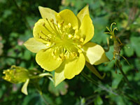
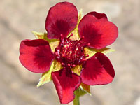
The canyon rounds a bend, below a photogenic, streaked cliff, near a good wildflower location that includes four bright red species growing close together (cardinal flower, california fuchsia, scarlet cinquefoil and washington monkeyflower), and continues with a lengthy section of trickling shallows over slickrock. A deeper pool is followed by a dark channel, a series of boulders, and another narrow, deep pool, passed by walking along a shelf on the left side. After more boulders, pools and cascades, the canyon bends to the left (north) and becomes wider and bushier once more, on to a section with deep red rocks below an overhanging cliff. A steep tributary joins from the southwest as the canyon angles back to the north, running through more nice passages lined with many green-flowered bog orchids in midsummer. A long straight, now 2 miles from the end of the trail, leads to a temporarily less distinctive section, before the widest pool, also quite long, and at its narrowest point 6 feet or more deep, though passable via a shallower wade along a slippery, submerged shelf.
The Upper Canyon
Next is a pretty bend and another bushy, tree-lined section, at one point bordered by a big sandy overhang, on the right side, used (illegally) for primitive camping, with litter, graffiti on the walls, and remains of fires at its base. The canyon floor widens around the junction with Barney Spring Canyon, soon followed by a smaller tributary, also on the west side. The bushy narrows lead to a some algae-covered pools and past an east-side tributary originating beneath Harding Point, this about 3 miles from the end of the trail. Some smaller, steeply-descending ravines join from the east as the cliffs above become somewhat less sheer, and the canyon more generally overgrown, as the red Hermit shale around the creekbed is replaced by the greyish Coconino sandstone. Rockfalls and downed trees are frequent, slowing progress. The gorge bends to the west and thereafter stays largely free of big pools or confined sections, apart from a narrow, flooded stretch after 4.8 miles and a few more deep pools around a narrow bend after 6.1 miles, approaching Casner Cabin Draw.
Nearby Slot Canyons
West Fork of Oak Creek - Similar Hikes
All Contents © Copyright The American Southwest | Comments and Questions | Contribute | Affiliate Marketing Disclosure | Site Map