Paria River
Rival of the Zion Narrows to be the best narrow, water-filled canyon in the Southwest - a usually shallow river flowing through miles of enclosed passageways between sheer cliffs up to 1,000 feet high. The wider gorge below the narrows has other interesting sites including arches and petroglyphs
Length: 4 miles to the start of the narrows, 7 miles to the Buckskin Gulch confluence; 35 miles to the Colorado River at Lees Ferry
Difficulty: Easy, but long; no significant obstructions. High flash flood danger
Management: BLM - part of Paria Canyon-Vermilion Cliffs Wilderness, and mostly within Vermilion Cliffs National Monument
Rocks: Navajo sandstone
Season: Late spring to fall, though not for several days after recent rains
Trailhead: End of a gravel track south of the Paria Ranger Station (White House Trailhead)
Rating (1-5): ★★★★★

The Paria River is the one major tributary of the Colorado between Lake Powell and the start of the Grand Canyon; the upper reaches flow across rocky, deserted land that now forms part of the Grand Staircase-Escalante National Monument - this is roadless for the most part, not easily accessed but filled with many cliffs, arches and other rock formations. Further south, the river crosses US 89 and the Arizona border, before eventually joining the Colorado at Lees Ferry. Various smaller streams join the Paria, often flowing through twisting, narrow canyons, most famous of which is Buckskin Gulch, the longest and deepest slot canyon in the USA. The whole area is pristine desert wilderness, and months could be spend exploring it.
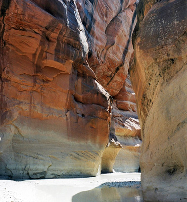
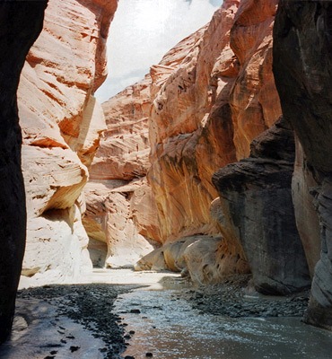
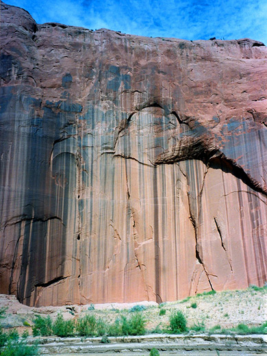
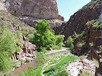
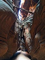
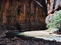
The main river generally flows through quite a wide valley with gently sloping sides, and the year round waters sustain a thin corridor of greenery in this otherwise arid land which is dry for most of the year - the exception is the few miles above and below the confluence with Buckskin where the river becomes enclosed by sheer cliffs up to 1,000 feet high and in places only a few yards apart; the journey through this section is traditionally considered one of the two best extended narrow canyon hikes in the Southwest, together with the Zion Canyon Narrows.
Topographic map of the Paria River.
The same general rules apply as for Buckskin Gulch.
12 views of the Paria River.
The Paria River narrows can be accessed via Buckskin Gulch, but only as part of an overnight backpacking trip as the journey to the confluence takes most of one day. The majority of people approach from the White House trailhead, reached from US 89, as this allows the most photogenic parts of the canyon to be visited in a single day, although continuing downstream all the way to Lees Ferry is a popular option, and this trip takes 3-4 days. The trailhead is 2 miles along a gravel track that leaves US 89 just east of the bridge over the river. The BLM Paria Ranger Station is located near the start of the track, as is the self-pay fee station and a noticeboard where weather and flood danger level information are posted daily. There is a small campground at the end of the track, and a trail register. The river is just 50 yards away at this point.
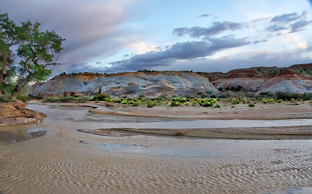
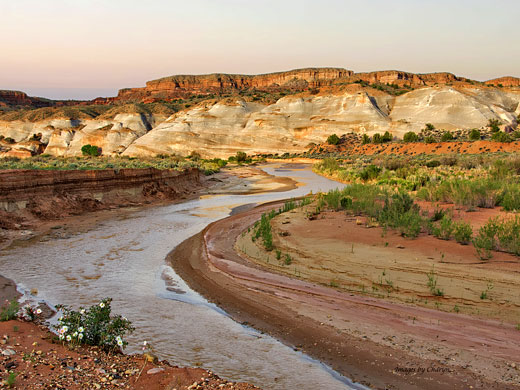
Near the trailhead, the Paria River is wide and shallow, flowing through a wide valley with low cliffs at the far side, much the same as the previous 35 miles. For most of the year, the water is only a few inches deep although fast flowing and quite muddy, but various different levels of deposited sand and pebbles at the sides testify to the occasional ferocious floods that tear down the canyon - even in this wide section, the river can reach a depth of several feet and be many yards across. But for a short time in early summer the drainage may be completely dry, due to lack of rain and/or upstream damming of the flow.
For half a mile after the trailhead a path runs though the grassy mounds along the east side of the river. Thereafter the route crosses the river many times and leads through alternating banks of higher land at both sides - some of these are quite extensive, bearing trees and bushes, and would make excellent places to camp.
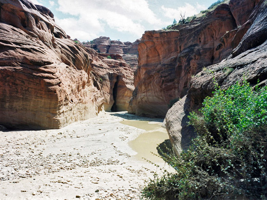
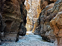
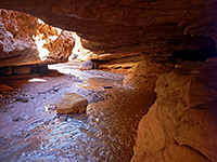
For over 4 miles, the river valley remains quite wide although with some steep high cliffs and occasional short, narrow side canyons, until, after a long gradual bend westwards, the river turns quite sharply east and the walls close in, soon becoming around 200 feet high. Flood levels here are many feet above the normal flow. Depending on the water depth there will usually still be frequent patches of sand and stones, while also likely are sections with water up to 2 feet deep, many areas of sticky mud, and short stretches of quicksand, but nothing too dangerous.
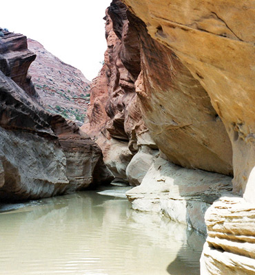
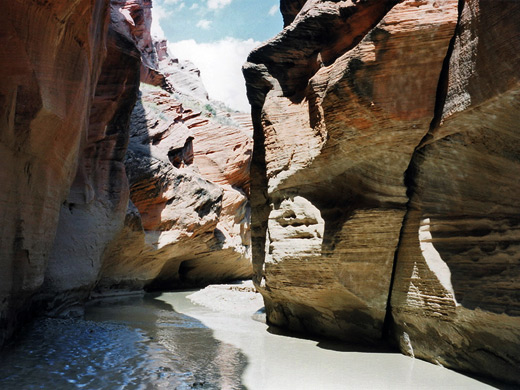
The coffee-colored, fast-flowing waters trickle in a pleasantly noisy fashion, contributing to a memorable wilderness experience, as there is usually no sign of other people, and around every corner appears a new section of pretty curved rock formations with enchanting patterns of shadows and sunlight. After about 3 miles of narrows, the Paria arrives at the confluence with Buckskin Gulch, a point still 2 miles before the canyon starts to widen and allow climbing out towards the rim - there are no easy escape routes in the narrowest section. Further downstream, the canyon is wider but becomes deeper still, albeit with less steep cliffs around the final section approaching the Colorado. There are no obstacles when hiking along the Paria River, although wading through water for several miles can become rather tiring. Weather conditions permitting, the 14 mile round trip to the Buckskin Gulch confluence is one of the best one-day hikes in the Southwest.
The main river generally flows through quite a wide valley with gently sloping sides, and the year round waters sustain a thin corridor of greenery in this otherwise arid land which is dry for most of the year - the exception is the few miles above and below the confluence with Buckskin where the river becomes enclosed by sheer cliffs up to 1,000 feet high and in places only a few yards apart; the journey through this section is traditionally considered one of the two best extended narrow canyon hikes in the Southwest, together with the Zion Canyon Narrows.
Map
Topographic map of the Paria River.
Permit
The same general rules apply as for Buckskin Gulch.
Photographs
12 views of the Paria River.
Location
The Paria River narrows can be accessed via Buckskin Gulch, but only as part of an overnight backpacking trip as the journey to the confluence takes most of one day. The majority of people approach from the White House trailhead, reached from US 89, as this allows the most photogenic parts of the canyon to be visited in a single day, although continuing downstream all the way to Lees Ferry is a popular option, and this trip takes 3-4 days. The trailhead is 2 miles along a gravel track that leaves US 89 just east of the bridge over the river. The BLM Paria Ranger Station is located near the start of the track, as is the self-pay fee station and a noticeboard where weather and flood danger level information are posted daily. There is a small campground at the end of the track, and a trail register. The river is just 50 yards away at this point.
Paria River Route Description
Near the trailhead, the Paria River is wide and shallow, flowing through a wide valley with low cliffs at the far side, much the same as the previous 35 miles. For most of the year, the water is only a few inches deep although fast flowing and quite muddy, but various different levels of deposited sand and pebbles at the sides testify to the occasional ferocious floods that tear down the canyon - even in this wide section, the river can reach a depth of several feet and be many yards across. But for a short time in early summer the drainage may be completely dry, due to lack of rain and/or upstream damming of the flow.
For half a mile after the trailhead a path runs though the grassy mounds along the east side of the river. Thereafter the route crosses the river many times and leads through alternating banks of higher land at both sides - some of these are quite extensive, bearing trees and bushes, and would make excellent places to camp.
The Canyon
For over 4 miles, the river valley remains quite wide although with some steep high cliffs and occasional short, narrow side canyons, until, after a long gradual bend westwards, the river turns quite sharply east and the walls close in, soon becoming around 200 feet high. Flood levels here are many feet above the normal flow. Depending on the water depth there will usually still be frequent patches of sand and stones, while also likely are sections with water up to 2 feet deep, many areas of sticky mud, and short stretches of quicksand, but nothing too dangerous.
Buckskin Gulch Confluence
The coffee-colored, fast-flowing waters trickle in a pleasantly noisy fashion, contributing to a memorable wilderness experience, as there is usually no sign of other people, and around every corner appears a new section of pretty curved rock formations with enchanting patterns of shadows and sunlight. After about 3 miles of narrows, the Paria arrives at the confluence with Buckskin Gulch, a point still 2 miles before the canyon starts to widen and allow climbing out towards the rim - there are no easy escape routes in the narrowest section. Further downstream, the canyon is wider but becomes deeper still, albeit with less steep cliffs around the final section approaching the Colorado. There are no obstacles when hiking along the Paria River, although wading through water for several miles can become rather tiring. Weather conditions permitting, the 14 mile round trip to the Buckskin Gulch confluence is one of the best one-day hikes in the Southwest.
Paria River Canyon - Similar Hikes
All Contents © Copyright The American Southwest | Comments and Questions | Contribute | Affiliate Marketing Disclosure | Site Map