Water Holes Canyon
Branched drainage that forms several beautiful sections of slot canyon, separated by wide, sandy washes; short, pretty very narrow slots in the upper forks and a deeper, more extended gorge lower down. As of May 2018, all parts of the canyon may only be visited as part of a guided tour
Length: Lower canyon, west of US 89: 1 mile (to the first rappel point). Middle canyon, east of US 89: 1.3 miles. West Fork: 6 miles. Middle Fork: 4.5 miles
Difficulty: Easy - there are few obstacles in the upper forks. The lower canyon eventually requires rappelling and difficult downclimbing
Management: Navajo Nation
Rocks: Navajo sandstone
Season: All year
Trailhead: Parking area on the east side of US 89
Rating (1-5): ★★★★★
Difficulty: Easy - there are few obstacles in the upper forks. The lower canyon eventually requires rappelling and difficult downclimbing
Management: Navajo Nation
Rocks: Navajo sandstone
Season: All year
Trailhead: Parking area on the east side of US 89
Rating (1-5): ★★★★★

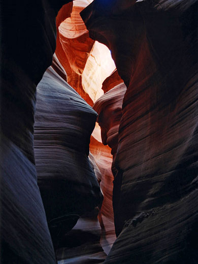
Water Holes is a branched drainage that forms several beautiful slot canyons, cutting through the red Navajo sandstone rocks around Lake Powell. It is only a few miles from Page and flows into the short section of Glen Canyon that remains intact; as with nearby Antelope Canyon, the watercourse extends either side of a main road (US 89) and becomes much deeper downstream, with a number of sheer drops.
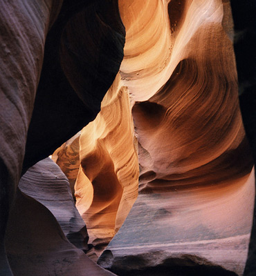
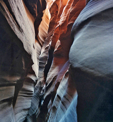
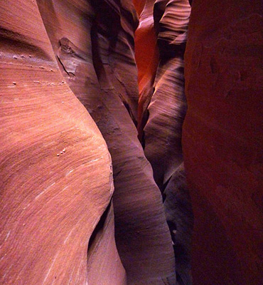
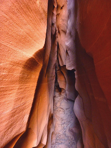
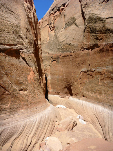
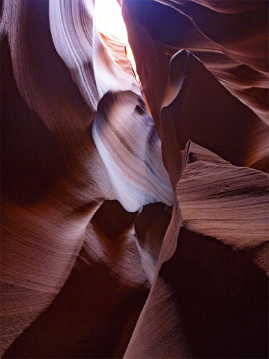
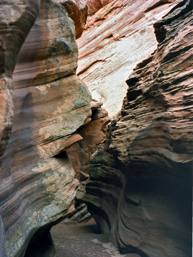
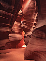
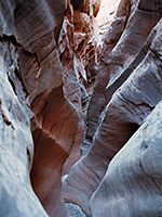
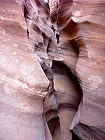
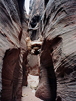
Various narrow passageways both west and especially east of the road have exceptionally pretty rock formations with the curved, delicately colored sandstone characteristic of this region, here nicely illuminated as the canyon although often very narrow is in general not too deep for sunlight to be excluded. Also like Antelope, Water Holes becomes a wide sandy wash above the lower narrows but then splits into a number of upper tributaries, some of which also have slot sections, mostly quite short but still narrow, pretty, and varied in character. Major sections are west of US 89, east of US 89, upper west fork and upper middle fork.
Despite being close to Page and the main highway, Water Holes is not too well known and is visited much less often than Antelope Canyon. The drainage runs east-west about 7 miles south of Page, meeting the Colorado River a short distance above Lees Ferry, passing under US 89 at milepost 542 and extending about 5 miles southeast, where it branches into three main forks, then a dozen or so smaller ones.
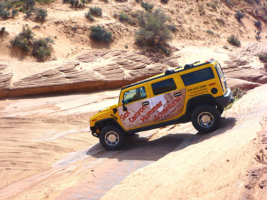
All of Water Holes Canyon lies on Navajo land and for many years the only requirement for entry was to purchase a hiking permit ($5), from the Tribal Parks Office next to the Leche-e Chapter House, 3 miles south of Page along the Copper Mine Road - either at the office on the day of the visit, or in advance by postal applications (see navajonationparks.org/permits). Initially all parts of the canyon were open, but from 2010 only the closest narrows on the east side of US 89 could be visited; all the upper tributaries were henceforth restricted to guests of a local tour company, which currently charges over $100 for escorted tours using 4WD vehicles, in particular to one slot in the middle fork of the upper wash known as Secret Canyon, or Horseshoe Bend Canyon. Then in May 2018 the general closure was extended to the whole canyon, so now even the slot section beside the highway can only be seen via a tour, cost around $70 per person. A notice beside the traditional parking area at the US 89 bridge advises that visiting this area unaccompanied is a violation of federal and tribal law.
See the narrows on a Navajo guided tour - the only way to visit the canyon.
West and East of US 89
Middle Fork of the Upper Canyon
West Fork of the Upper Canyon
Water Holes Canyon has several distinct sections of narrows:
Various narrow passageways both west and especially east of the road have exceptionally pretty rock formations with the curved, delicately colored sandstone characteristic of this region, here nicely illuminated as the canyon although often very narrow is in general not too deep for sunlight to be excluded. Also like Antelope, Water Holes becomes a wide sandy wash above the lower narrows but then splits into a number of upper tributaries, some of which also have slot sections, mostly quite short but still narrow, pretty, and varied in character. Major sections are west of US 89, east of US 89, upper west fork and upper middle fork.
Location
Despite being close to Page and the main highway, Water Holes is not too well known and is visited much less often than Antelope Canyon. The drainage runs east-west about 7 miles south of Page, meeting the Colorado River a short distance above Lees Ferry, passing under US 89 at milepost 542 and extending about 5 miles southeast, where it branches into three main forks, then a dozen or so smaller ones.
Access Restrictions
All of Water Holes Canyon lies on Navajo land and for many years the only requirement for entry was to purchase a hiking permit ($5), from the Tribal Parks Office next to the Leche-e Chapter House, 3 miles south of Page along the Copper Mine Road - either at the office on the day of the visit, or in advance by postal applications (see navajonationparks.org/permits). Initially all parts of the canyon were open, but from 2010 only the closest narrows on the east side of US 89 could be visited; all the upper tributaries were henceforth restricted to guests of a local tour company, which currently charges over $100 for escorted tours using 4WD vehicles, in particular to one slot in the middle fork of the upper wash known as Secret Canyon, or Horseshoe Bend Canyon. Then in May 2018 the general closure was extended to the whole canyon, so now even the slot section beside the highway can only be seen via a tour, cost around $70 per person. A notice beside the traditional parking area at the US 89 bridge advises that visiting this area unaccompanied is a violation of federal and tribal law.
Tours of Secret Canyon
See the narrows on a Navajo guided tour - the only way to visit the canyon.
Photographs
West and East of US 89
Middle Fork of the Upper Canyon
West Fork of the Upper Canyon
Route Description
Water Holes Canyon has several distinct sections of narrows:
- West of US 89: Between the highway and the junction with Glen Canyon are various vertical drops of up to 50 feet, so following all the way downstream requires use of several ropes, although by a combination of rim walking and use of different entry/exit points to hike along specific sections, a reasonable amount may be seen without rappelling.
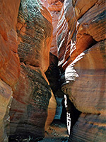
- East of US 89: The canyon immediately east of US 89 is less deep, but has nicer narrows and is quite easy to follow. From May 2018 this section, like all other parts of the drainage, may only be seen by joining a guided tour.
- West Fork of the Upper Canyon: The west, or main fork of Water Holes Canyon itself splits into three branches, all of which have good, short, colorful narrows.
- Middle Fork of the Upper Canyon: One branch of the upper drainage, three miles from US 89, has a short, deep slot (previously informally known as 'Secret Canyon', now 'Horseshoe Bend Canyon') that rivals Antelope Canyon for nicely lit, swirling formations, while a little way further upstream is the darkest, narrowest slot of the whole system, though rather more effort is necessary to reach it - or at least this used to be the case, but now the only approach is via a guided tour.
Nearby Slot Canyons
Water Holes Canyon is one of the top 25 slot canyons
Water Holes Canyon - Similar Hikes
All Contents © Copyright The American Southwest | Comments and Questions | Contribute | Affiliate Marketing Disclosure | Site Map