Rainbow Canyon, Lake Mead National Recreation Area
Arizona > Lake Mead National Recreation Area > Rainbow Canyon
Rainbow Canyon
Shallow ravine, a tributary of Lovell Wash, through colorful rock layers, mainly limestone. Explored by a partly off-trail hike that also loops round an isolated ridge topped by jagged strata, known as the Giant Fin. Along the way is a photogenic double arch
Length: 5.2 miles, round trip
Elevation change: 380 feet
Difficulty: Easy to moderate
Type: Partial loop, partly off-trail
Usage: Low
Season: Fall, winter, spring; summers are generally too hot
Trailhead: Pullout along Hwy 167, at the start of Callville Wash Road
Rating (1-5): ★★★★★
Elevation change: 380 feet
Difficulty: Easy to moderate
Type: Partial loop, partly off-trail
Usage: Low
Season: Fall, winter, spring; summers are generally too hot
Trailhead: Pullout along Hwy 167, at the start of Callville Wash Road
Rating (1-5): ★★★★★

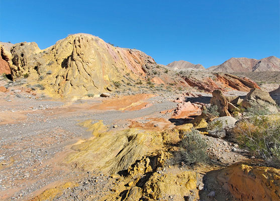
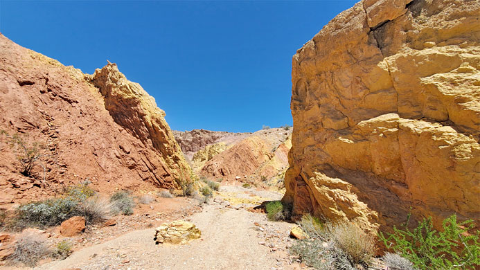
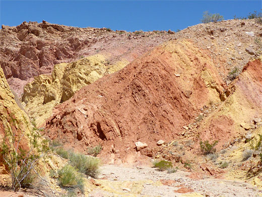
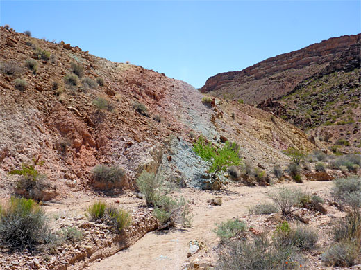
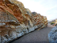
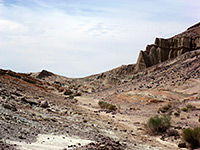
Rainbow Canyon is the unofficial name of a minor tributary of Lovell Wash, on the north side of Lake Mead, close to Northshore Road (Hwy 167), and is so-called because of the multicolored rock in its lower end, in shades of gray, red, yellow, pink, brown and green. Most is limestone, from the Horse Spring Formation, plus sandstone from the Moenkopi Formation. The bright colors extend around half mile along the lower end of the wash, above which, the next mile, to the upper end, is lined by more homogenous strata, gray or brown.
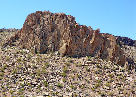
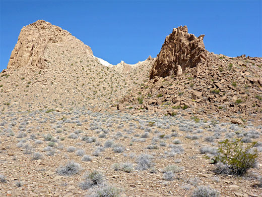
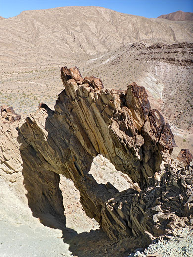
The wash is shallow and has no obstructions, so the walk upstream is easy, and can be extended by a loop around an isolated limestone ridge, topped by jagged strata, upturned at nearly 90 degrees, known as the Giant Fin. This section is along a 4WD track and a path, while the start of a hike is all along the streambed.
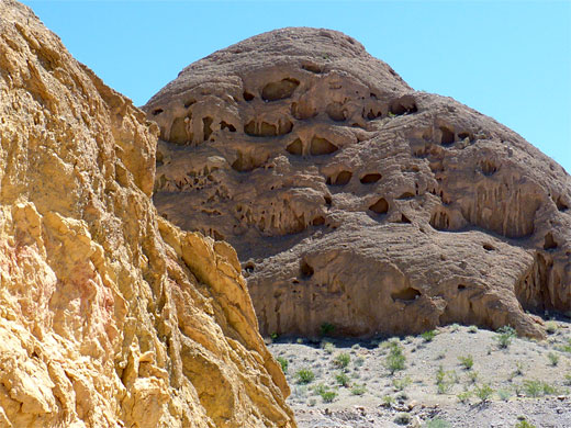
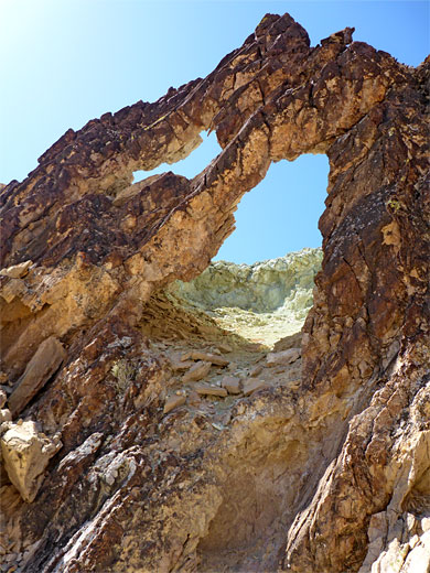
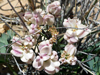
Also of note is an unusual double arch in the limestone, on the north side of the Giant Fin, while the hike is of general interest for the solitude and the long-distance views over the desert, from the upper reaches. Wildflowers are plentiful, despite the generally barren soil, which is gypsum-rich in some locations; uncommon species found here include Gilman's cymopterus, Las Vegas bearpoppy and silverleaf sunray.
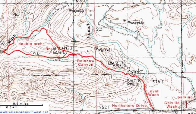
The round trip is 5.2 miles, typically taking around three hours. The approach up Lovell Wash and the end of Rainbow Canyon is within Lake Mead NRA, while beyond that, the remainder of the wash, and the fin, are on the adjoining public land.
Map of Lake Mead National Recreation Area.
29 views of Rainbow Canyon.
Scenes along the canyon, walking downstream from the Giant Fin.
The lower end of Rainbow Canyon meets Lovell Wash half mile north of the point where it crosses Northshore Road. The nearest place to park is 1600 feet east, at a wide gravel area by the junction with Callville Wash Road. The confluence of the canyons is then reached either by walking alongside the road, on the rather narrow verge, and up Lovell Wash, or cross country, initially over Callville Wash, then up a slope, across a flat limestone plateau dotted with tiny wildflowers, and finally down to Lovell Wash.
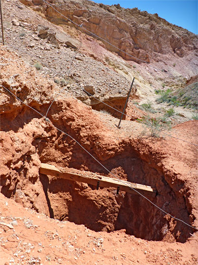
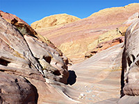
Rocks around this section of Lovell Wash, adjoining Northshore Road, are mainly gray with a few patches of red, from three components of the Moenkopi Formation namely; from south to north they are the Upper Red Member, the Shnabkaib Member and the Virgin Limestone, this generally greenish or yellowish and extending to just south of the Rainbow Canyon confluence, where the bedrock changes to the Horse Spring Formation, specifically the Bitter Ridge Limestone Member, which is much more colorful; bands of yellow, light brown, pink and red. Upstream, this drainage moves round a wide bend, past a loosely-fenced shaft into a patch of bright red rock, followed by several more bends, the canyon somewhat enclosed for while, before becoming shallow and open, as the colors gradually fade away. Around this part of the wash are several clusters of the Las Vegas bearpoppy.
The wash continues west below a narrow ridge topped by jagged strata, the Giant Fin. After a while an old roadbed is evident, just north of the wash, providing an easy walk, for one mile, to the junction with a more well-used track, alongside Borax Wash. The next section of the loop hike is right (northeast) along here for half a mile, climbing a bit, moving round to the north side of the Giant Fin then turning right along a faint path, now heading back southeast. This path crosses a flat area, traverses round the head of a valley and passes below a dark limestone fin containing the double arch, after which it descends gradually to Rainbow Canyon, meeting it near the far end of the old roadbed.
The wash is shallow and has no obstructions, so the walk upstream is easy, and can be extended by a loop around an isolated limestone ridge, topped by jagged strata, upturned at nearly 90 degrees, known as the Giant Fin. This section is along a 4WD track and a path, while the start of a hike is all along the streambed.
Also of note is an unusual double arch in the limestone, on the north side of the Giant Fin, while the hike is of general interest for the solitude and the long-distance views over the desert, from the upper reaches. Wildflowers are plentiful, despite the generally barren soil, which is gypsum-rich in some locations; uncommon species found here include Gilman's cymopterus, Las Vegas bearpoppy and silverleaf sunray.
The round trip is 5.2 miles, typically taking around three hours. The approach up Lovell Wash and the end of Rainbow Canyon is within Lake Mead NRA, while beyond that, the remainder of the wash, and the fin, are on the adjoining public land.
Location
Map of Lake Mead National Recreation Area.
Photographs
29 views of Rainbow Canyon.
Rainbow Canyon Video
Scenes along the canyon, walking downstream from the Giant Fin.
Access
The lower end of Rainbow Canyon meets Lovell Wash half mile north of the point where it crosses Northshore Road. The nearest place to park is 1600 feet east, at a wide gravel area by the junction with Callville Wash Road. The confluence of the canyons is then reached either by walking alongside the road, on the rather narrow verge, and up Lovell Wash, or cross country, initially over Callville Wash, then up a slope, across a flat limestone plateau dotted with tiny wildflowers, and finally down to Lovell Wash.
The Canyon
Rocks around this section of Lovell Wash, adjoining Northshore Road, are mainly gray with a few patches of red, from three components of the Moenkopi Formation namely; from south to north they are the Upper Red Member, the Shnabkaib Member and the Virgin Limestone, this generally greenish or yellowish and extending to just south of the Rainbow Canyon confluence, where the bedrock changes to the Horse Spring Formation, specifically the Bitter Ridge Limestone Member, which is much more colorful; bands of yellow, light brown, pink and red. Upstream, this drainage moves round a wide bend, past a loosely-fenced shaft into a patch of bright red rock, followed by several more bends, the canyon somewhat enclosed for while, before becoming shallow and open, as the colors gradually fade away. Around this part of the wash are several clusters of the Las Vegas bearpoppy.
Giant Fin and the Double Arch
The wash continues west below a narrow ridge topped by jagged strata, the Giant Fin. After a while an old roadbed is evident, just north of the wash, providing an easy walk, for one mile, to the junction with a more well-used track, alongside Borax Wash. The next section of the loop hike is right (northeast) along here for half a mile, climbing a bit, moving round to the north side of the Giant Fin then turning right along a faint path, now heading back southeast. This path crosses a flat area, traverses round the head of a valley and passes below a dark limestone fin containing the double arch, after which it descends gradually to Rainbow Canyon, meeting it near the far end of the old roadbed.
Rainbow Canyon Topographic Map
Rainbow Canyon Wildflowers
More flowers along the canyon
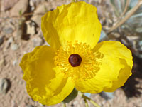
 Gilman's cymopterus |
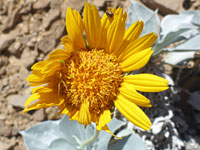
 Las Vegas bearpoppy |
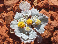
 Silverleaf sunray |
 Annual turtleback |
More flowers along the canyon
Rainbow Canyon - Similar Hikes


All Contents © Copyright The American Southwest | Comments and Questions | Contribute | Affiliate Marketing Disclosure | Site Map