North Fork Lone Pine Creek Trail, Eastern Sierra
California > Eastern Sierra > North Fork Lone Pine Creek Trail
North Fork Lone Pine Creek Trail
Steep trail, branching off the main path from Whitney Portal, ascending a boulder-filled ravine, above the treeline, to Lower Boy Scout Lake, just outside the Mt Whitney permit zone. The path continues to Clyde Meadow, then Iceberg lake, forming part of the Mountaineers Route to the Whitney summit
Length: 1.7 miles to Lower Boy Scout Lake, 2.5 miles to Clyde Meadow
Elevation change: 2,020 feet, 2,810 feet
Difficulty: Strenuous; path is overgrown in parts, and consistently steep, with some exposure
Type: One-way
Usage: Low to medium
Season: Early summer to early fall
Trailhead: Whitney Portal, 12 miles from Lone Pine
Rating (1-5): ★★★★★
Elevation change: 2,020 feet, 2,810 feet
Difficulty: Strenuous; path is overgrown in parts, and consistently steep, with some exposure
Type: One-way
Usage: Low to medium
Season: Early summer to early fall
Trailhead: Whitney Portal, 12 miles from Lone Pine
Rating (1-5): ★★★★★

Perhaps the busiest and most popular trailhead in the Eastern Sierra is Whitney Portal, along a paved road 12 miles west of Lone Pine. The main hiking destination is of course the summit of 14,505 foot Mount Whitney, the highest point in the lower 48 states, but there are several intermediate targets, including lakes, meadows and viewpoints. The principal trail follows Lone Pine Creek up to the Sierra crest then traverses northwards to the summit, while an alternative approach, the 'Mountaineers Route' ascends the North Fork Lone Pine Creek, reaching the crest more directly, just north of the summit.
Hiking in the spectacular high country hereabouts is however complicated by the need to acquire a permit, since the popularity demands limitation of visitor numbers, in order to protect the environment. Like many such systems the processes is rather complex; for the whole of the summer season (May to October), for either day or overnight hikes, people need to apply during the month of February, after which successful candidates are chosen by a lottery, the results announced in mid-March. Typically only around a quarter of applicants are successful. There are never any walk-in permits available. In winter, November to April, permits are still needed but there is no limit on numbers.
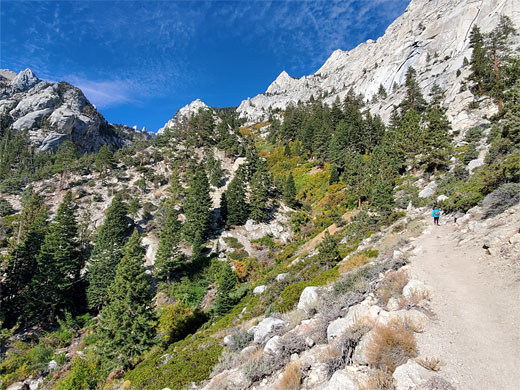
People without permits can still take a shorter hike, since the permit zone starts some way above the trailhead. Just a short distance along either of the two trails is worthwhile, but best is the North Fork Lone Pine Creek Trail, which climbs steeply up a scenic, cliff-lined canyon to Lower Boy Scout Lake, set in a secluded basin with grand views down the canyon towards Owens Valley and up towards the high peaks. A second destination, 0.8 miles further is Clyde Meadow, a flattish, rocky area where views of the Sierra crest are even better. The hike to this point is 2.5 miles gaining 2,810 feet, testing and scenic, yet relatively short.
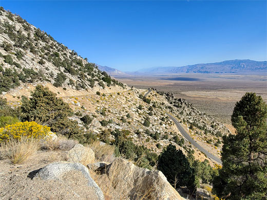
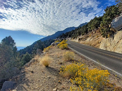
Like Horseshoe Meadows Road, 8 miles south, the road to Whitney Portal, after passing through the Alabama Hills, zig-zags up the Sierra foothills, affording a fantastic vista up and down Owens Valley. It then heads up the canyon of Lone Pine Creek, climbing more gradually, ending with a short loop in thick pine woods, elevation 8,330 feet. Along the latter stages of the road are various campsites, parking places and buildings, including a very useful store/restaurant/bar. Most of time, parking spaces are available right at the end of the road, from where the trail starts, just behind the restaurant; near a shallow pond at the center of the parking loop, close to the north fork of the creek.
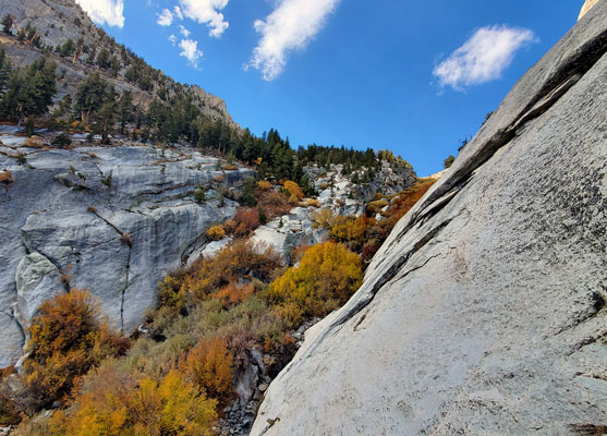
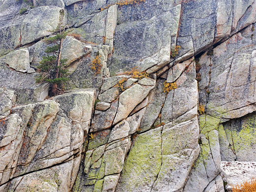
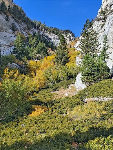
The one path at the end of Whitney Portal Road, the main route to Mount Whitney, soon leaves the shady woods, traversing east, away from the mountains over an exposed slope, dry and dusty in summer, before cutting back west, climbing only gently, through a wooded corridor centered on a tiny stream, then over more open slopes, almost level now, and down to a larger stream, the North Fork Lone Pine Creek. Here is a somewhat inconspicuous junction with the north fork trail, leaving the main route and ascending much more steeply, initially through a group of tall pines. These do not extend too far; the path leaves the upper edge of the wooded zone, into a bushy, boulder-filled ravine. It soon crosses to the south side, climbing steeply again through thickets of distorted willow, plus the occasional pine, winding past many huge boulders.
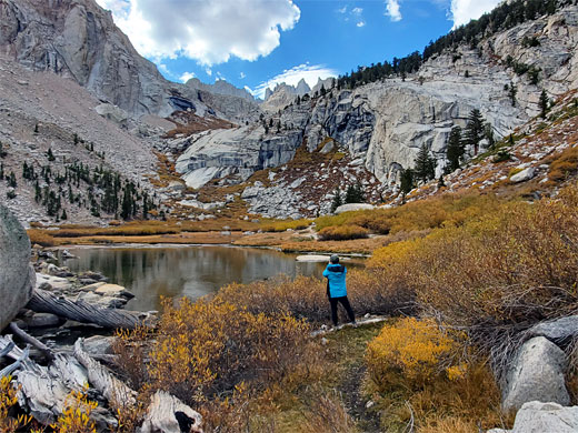
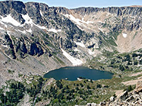
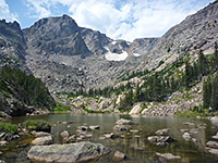
The trail descends slightly, re-crosses the creek and briefly cuts back east, now over open rocky slopes, of light-grey granodiorite. A few ledges need to be climbed, with some exposure. The path reaches the base of a cliff and bends once more to the west, now not so steep, gradually moving back to the creekbed and up one last bushy section, over a brow, to the edge of Lower Boy Scout Lake, which is usually shadow and muddy, but still photogenic, ringed on three sides by barren slopes of rock and talus.
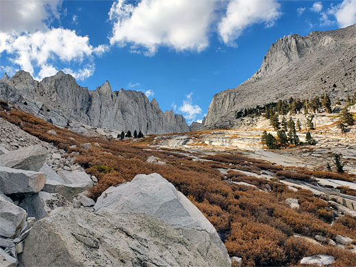
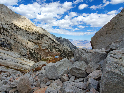
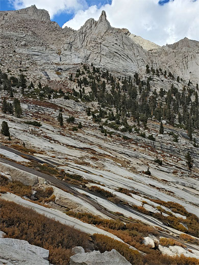
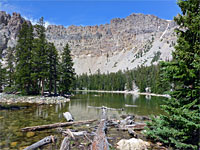
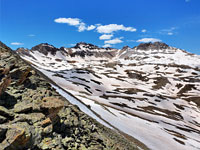
The path continues, around the south side of the lake, along the edge of a boggy meadow and up a steep slope of huge boulders, close to the creek. The gradient relents and the path enters a gently-sloping area of bushes and a few patches of grass; this is Clyde Meadow, elevation 11,000 feet, now with much better views of the jagged peaks of the Sierra crest, still a long way above. Upper Boy Scout Lake is not far beyond, before the next big climb up to Iceberg Lake, but both these are within the permit zone, so people without a permit can go no further than the meadow.
Hiking in the spectacular high country hereabouts is however complicated by the need to acquire a permit, since the popularity demands limitation of visitor numbers, in order to protect the environment. Like many such systems the processes is rather complex; for the whole of the summer season (May to October), for either day or overnight hikes, people need to apply during the month of February, after which successful candidates are chosen by a lottery, the results announced in mid-March. Typically only around a quarter of applicants are successful. There are never any walk-in permits available. In winter, November to April, permits are still needed but there is no limit on numbers.
People without permits can still take a shorter hike, since the permit zone starts some way above the trailhead. Just a short distance along either of the two trails is worthwhile, but best is the North Fork Lone Pine Creek Trail, which climbs steeply up a scenic, cliff-lined canyon to Lower Boy Scout Lake, set in a secluded basin with grand views down the canyon towards Owens Valley and up towards the high peaks. A second destination, 0.8 miles further is Clyde Meadow, a flattish, rocky area where views of the Sierra crest are even better. The hike to this point is 2.5 miles gaining 2,810 feet, testing and scenic, yet relatively short.
Whitney Portal Road
Like Horseshoe Meadows Road, 8 miles south, the road to Whitney Portal, after passing through the Alabama Hills, zig-zags up the Sierra foothills, affording a fantastic vista up and down Owens Valley. It then heads up the canyon of Lone Pine Creek, climbing more gradually, ending with a short loop in thick pine woods, elevation 8,330 feet. Along the latter stages of the road are various campsites, parking places and buildings, including a very useful store/restaurant/bar. Most of time, parking spaces are available right at the end of the road, from where the trail starts, just behind the restaurant; near a shallow pond at the center of the parking loop, close to the north fork of the creek.
North Fork Lone Pine Creek
The one path at the end of Whitney Portal Road, the main route to Mount Whitney, soon leaves the shady woods, traversing east, away from the mountains over an exposed slope, dry and dusty in summer, before cutting back west, climbing only gently, through a wooded corridor centered on a tiny stream, then over more open slopes, almost level now, and down to a larger stream, the North Fork Lone Pine Creek. Here is a somewhat inconspicuous junction with the north fork trail, leaving the main route and ascending much more steeply, initially through a group of tall pines. These do not extend too far; the path leaves the upper edge of the wooded zone, into a bushy, boulder-filled ravine. It soon crosses to the south side, climbing steeply again through thickets of distorted willow, plus the occasional pine, winding past many huge boulders.
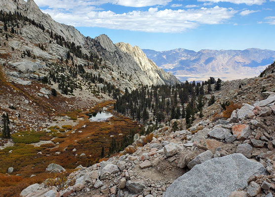
Lower Boy Scout Lake
The trail descends slightly, re-crosses the creek and briefly cuts back east, now over open rocky slopes, of light-grey granodiorite. A few ledges need to be climbed, with some exposure. The path reaches the base of a cliff and bends once more to the west, now not so steep, gradually moving back to the creekbed and up one last bushy section, over a brow, to the edge of Lower Boy Scout Lake, which is usually shadow and muddy, but still photogenic, ringed on three sides by barren slopes of rock and talus.
Cylde Meadow
The path continues, around the south side of the lake, along the edge of a boggy meadow and up a steep slope of huge boulders, close to the creek. The gradient relents and the path enters a gently-sloping area of bushes and a few patches of grass; this is Clyde Meadow, elevation 11,000 feet, now with much better views of the jagged peaks of the Sierra crest, still a long way above. Upper Boy Scout Lake is not far beyond, before the next big climb up to Iceberg Lake, but both these are within the permit zone, so people without a permit can go no further than the meadow.
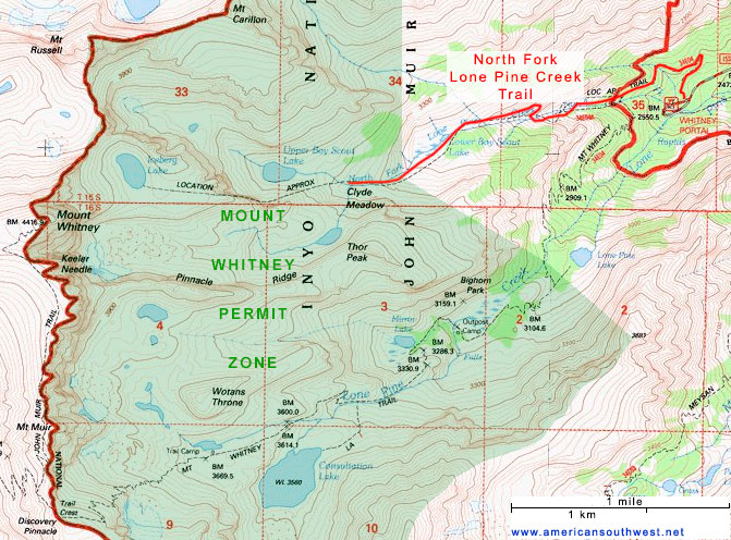
Topographic Map of the Mount Whitney Area
Lone Pine Creek Wildflowers
More flowers along the trail
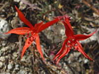 Skyrocket |
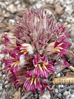 Flat-top broomrape |
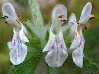 Whitestem hedgenettle |
More flowers along the trail
North Fork Lone Pine Creek Trail - Similar Hikes

All Contents © Copyright The American Southwest | Comments and Questions | Contribute | Affiliate Marketing Disclosure | Site Map