Alpine Lakes Loop Trail, Great Basin National Park
Nevada > Great Basin National Park > Alpine Lakes Loop Trail

Alpine Lakes Loop Trail
Popular path through a mix of woodland and meadows to a pair of lakes, in sheltered basins below the north face of Wheeler Peak
Length: 2.7 miles, round trip
Elevation change: 600 feet
Difficulty: Easy
Type: Loop
Usage: Medium
Season: Late spring, summer and early fall, since the access road is closed by snow at other times
Trailhead: Parking area near the end of the scenic drive
Rating (1-5): ★★★★★
Elevation change: 600 feet
Difficulty: Easy
Type: Loop
Usage: Medium
Season: Late spring, summer and early fall, since the access road is closed by snow at other times
Trailhead: Parking area near the end of the scenic drive
Rating (1-5): ★★★★★

The 2.7 mile Alpine Lakes Loop is the shortest of the main hiking trails in Great Basin National Park, and not at all difficult, climbing a little way up the northern slopes of Wheeler Peak through a mix of meadows and light woodland, passing two small, sheltered lakes within glacial cirques, at the foot of much steeper hillsides.
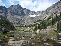
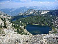
Stella Lake is the largest, and has the best views, southwards to the high summits, while the smaller Teresa Lake is more enclosed, though also prettier, containing turquoise, glacial water and lined by more vegetation. The trail crosses the exit streams from the lakes several times, flowing through generally dry woodland, but lined in many stretches by a good variety of wildflowers, including such riparian species as Sierra shooting star, Parry's primrose, brook saxifrage and white bog orchid. Both lakes are named after early settlers of this region.
The hike can be extended, up to 6.7 miles round trip, by the linked Bristlecone and Glacier Trail, which traverses a wooded slope and leads up a spectacular glacial valley directly below Wheeler Peak, past a grove of bristlecone pines to the base of a permanent snowfield.
Map of Great Basin National Park.
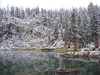
The Alpine Lakes Loop begins near the upper end of the scenic drive, shortly before Wheeler Peak campground, at elevation 9,960 feet; parking is a spacious lot in a clearing in the upper reaches of the valley of Lehman Creek, which is fed by the two lakes. The parking area is entirely enclosed by trees but the forest opens out in and around the campground, allowing good views of the mountains.
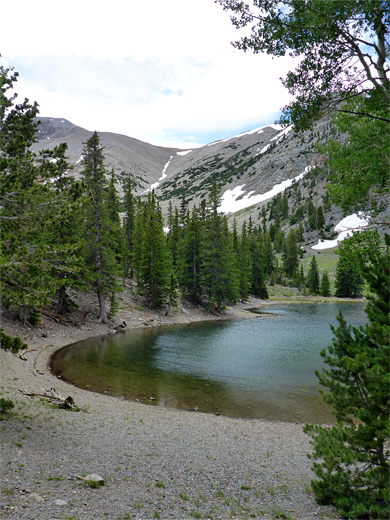
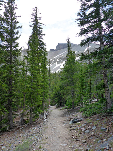
The trail first crosses the stream, here bordered by clumps of shooting stars, passes the junction with the 0.4 mile (loop), wheelchair-accessible Sky Islands Forest Trail, then arrives a second junction, at the start of the main loop. Turning right, the path returns to the stream, crosses via a footbridge to the north side and rises through gradually more open woodland, initially straight followed by one switchback, where gaps in the trees allow the first views of the peaks. The trees change from spruce and pine to aspen in the vicinity of another junction, along the path to the Wheeler Peak summit, which starts from an alternative trailhead a little way back along the road. Ahead is a long, dry meadow where the summit path forks off, then the first lake (Stella) is reached soon after, lined by unvegetated, stony flats and bordered to the east by a steep, sparsely-wooded slope.
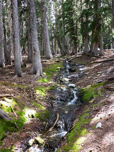
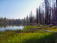
South of Stella Lake the path crosses over a slight rise, within sight of rocky slopes to the right, and proceeds through dry, level woodland before descending to a tiny, spring-fed stream, which provides some of the water of the next lake, Teresa. Parry's primrose grows profusely on the streambanks. The water in the lake is cloudy, turquoise in color, unlike the clear water of Stella Lake. The trail follows the eastern shoreline, descends a dry rock gully on the far side to the final junction, with the path to the glacial valley. Ahead, the last part of the loop descends more steeply through darker, moister woods with bigger trees, crosses the Teresa Lake exit stream a couple of times and returns to the junction near the parking area.
Stella Lake is the largest, and has the best views, southwards to the high summits, while the smaller Teresa Lake is more enclosed, though also prettier, containing turquoise, glacial water and lined by more vegetation. The trail crosses the exit streams from the lakes several times, flowing through generally dry woodland, but lined in many stretches by a good variety of wildflowers, including such riparian species as Sierra shooting star, Parry's primrose, brook saxifrage and white bog orchid. Both lakes are named after early settlers of this region.
The hike can be extended, up to 6.7 miles round trip, by the linked Bristlecone and Glacier Trail, which traverses a wooded slope and leads up a spectacular glacial valley directly below Wheeler Peak, past a grove of bristlecone pines to the base of a permanent snowfield.

Location
Map of Great Basin National Park.
Alpine Lakes Trailhead
The Alpine Lakes Loop begins near the upper end of the scenic drive, shortly before Wheeler Peak campground, at elevation 9,960 feet; parking is a spacious lot in a clearing in the upper reaches of the valley of Lehman Creek, which is fed by the two lakes. The parking area is entirely enclosed by trees but the forest opens out in and around the campground, allowing good views of the mountains.
Stella Lake
The trail first crosses the stream, here bordered by clumps of shooting stars, passes the junction with the 0.4 mile (loop), wheelchair-accessible Sky Islands Forest Trail, then arrives a second junction, at the start of the main loop. Turning right, the path returns to the stream, crosses via a footbridge to the north side and rises through gradually more open woodland, initially straight followed by one switchback, where gaps in the trees allow the first views of the peaks. The trees change from spruce and pine to aspen in the vicinity of another junction, along the path to the Wheeler Peak summit, which starts from an alternative trailhead a little way back along the road. Ahead is a long, dry meadow where the summit path forks off, then the first lake (Stella) is reached soon after, lined by unvegetated, stony flats and bordered to the east by a steep, sparsely-wooded slope.

Teresa Lake
South of Stella Lake the path crosses over a slight rise, within sight of rocky slopes to the right, and proceeds through dry, level woodland before descending to a tiny, spring-fed stream, which provides some of the water of the next lake, Teresa. Parry's primrose grows profusely on the streambanks. The water in the lake is cloudy, turquoise in color, unlike the clear water of Stella Lake. The trail follows the eastern shoreline, descends a dry rock gully on the far side to the final junction, with the path to the glacial valley. Ahead, the last part of the loop descends more steeply through darker, moister woods with bigger trees, crosses the Teresa Lake exit stream a couple of times and returns to the junction near the parking area.

Alpine Lakes Wildflowers
More flowers along the trail
 Sierra shooting star |
 Parry's primrose |
 Ballhead sandwort |
More flowers along the trail
Alpine Lakes Loop Trail - Similar Hikes

All Contents © Copyright The American Southwest | Comments and Questions | Contribute | Affiliate Marketing Disclosure | Site Map