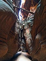
Potato Canyon
Lengthy tributary of Navajo Creek, splitting at its upper end into three deep, narrow, slot canyon branches through richly-colored sandstone, mostly inaccessible unless rappelling
Length: About 9 miles, round trip, to view the upper end of each fork, and walk along some of the canyon rims
Difficulty: Moderate to difficult - cross-country hiking, route-finding and scrambling
Management: Navajo Nation
Rocks: Navajo sandstone
Season: All year, though very hot in summer
Trailhead: Pull-out along Hwy 98, 47 miles southeast of Page
Rating (1-5): ★★★★★
Difficulty: Moderate to difficult - cross-country hiking, route-finding and scrambling
Management: Navajo Nation
Rocks: Navajo sandstone
Season: All year, though very hot in summer
Trailhead: Pull-out along Hwy 98, 47 miles southeast of Page
Rating (1-5): ★★★★★
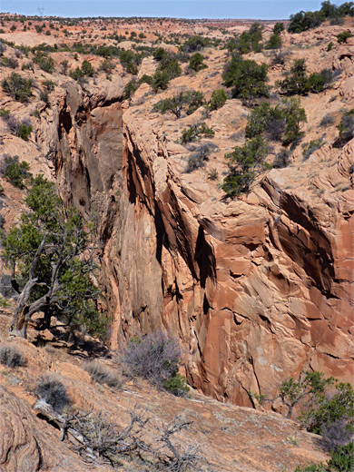
Potato Canyon is a relatively long tributary of Navajo Creek, in the Navajo Reservation of northeast Arizona; a broad, sheer-walled gorge for most of its length, around 500 feet deep and a quarter of a mile across at streambed level, but narrowing at the upper end to three very enclosed branches, all forming about one mile of slot canyon through the same richly colored Navajo sandstone that is exposed all the way to Lake Powell.
The main canyon contains a few ancient cliff dwellings and may be entered via a trail 4 miles downstream of the slots, after driving along a Navajo track, while the upper reaches are quite easily reached from Hwy 98, a suitable starting point being a large pullout on the north side, 47 miles southeast of Page - an elevated site overlooking a vast, mostly roadless expense of sand and slickrock extending to Navajo Mountain, 30 miles away. The terrain near the road is fairly easy to traverse since it has low relief and is crossed by several tracks, and navigation is assisted by high powerlines which cross two of the forks (west and main).
Although all three branches of Potato Canyon contain good, deep, narrow slots, all require rappelling to explore due to a series of climbable falls near the start, and several bolts and hangers fixed above suggest they are entered semi-regularly. Nevertheless, the shallow passageways at the start of the slots are still of interest, while rim-walking above the narrows offers grand views of the canyons and of the wider landscape. As with all hiking in the Navajo Reservation, a permit is required to explore the canyon, obtainable from the LeChee Chapter House in Page.

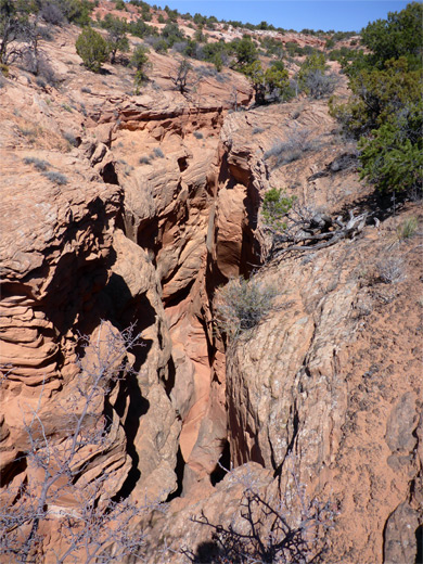
The roadside pullout, signed 'Scenic View', is near a high point along Hwy 98, close to Square Butte, an 7,130-foot peak. The closest of the three upper branches of Potato Canyon is the west fork, reached via a faint path that starts from a gap in the fence, down to a rough track, followed by a descent of a little twisting ravine to a somewhat wider, sandier track - Indian Route 22. To the west, this rounds two promontories and two small drainages, and is soon running alongside the west fork of the canyon, which forms shallow narrows near the road, then falls away 15-20 feet via a smooth chute, with a bolt and hanger on the right side. There seem to be no other possible entry points, and the ravine quickly drops further by other dryfalls, becoming over 200 feet deep in the vicinity of the powerlines, approaching the junction with the main fork.
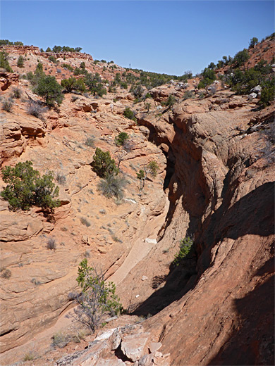
The main fork of the canyon is similarly deep and somewhat wider, and upstream of the west fork confluence gains height via a series of falls. Three tiny tributaries join from the west, one with a brief slot section preceding its own impassable fall, into a passage with potholes. Not for 1.5 miles (from the confluence) do the cliffs of the main fork relent, allowing descent to the streambed, but it is not possible to walk very far downstream before the first sheer drop.
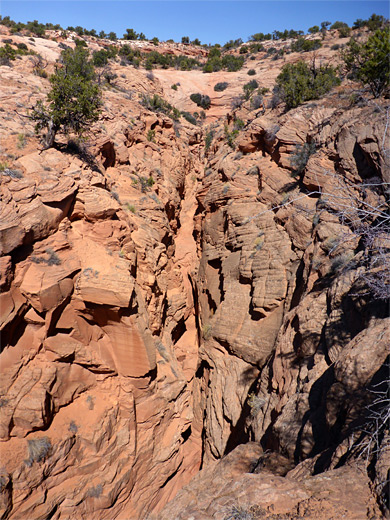
The east fork is one mile north of the shallow part of the main fork, reached by climbing the sloping ground above the narrows, up to an ancient track, following this as it moves around the west edge of a line of cliffs, over a sandy brow, under two sets of powerlines and across two other tracks, then cross-country still heading north, descending over slickrock towards the vertical-walled canyon, arriving near where it splits into two branches. The closer fork allows entry a little way east but once more has only a short stretch of curvy passages before an unclimbable drop. In general all the exposed rock surfaces are rather soft, flaky and often covered by loose sand, so not good for climbing, and making even minor drops impassable unless using ropes.
The main canyon contains a few ancient cliff dwellings and may be entered via a trail 4 miles downstream of the slots, after driving along a Navajo track, while the upper reaches are quite easily reached from Hwy 98, a suitable starting point being a large pullout on the north side, 47 miles southeast of Page - an elevated site overlooking a vast, mostly roadless expense of sand and slickrock extending to Navajo Mountain, 30 miles away. The terrain near the road is fairly easy to traverse since it has low relief and is crossed by several tracks, and navigation is assisted by high powerlines which cross two of the forks (west and main).
Although all three branches of Potato Canyon contain good, deep, narrow slots, all require rappelling to explore due to a series of climbable falls near the start, and several bolts and hangers fixed above suggest they are entered semi-regularly. Nevertheless, the shallow passageways at the start of the slots are still of interest, while rim-walking above the narrows offers grand views of the canyons and of the wider landscape. As with all hiking in the Navajo Reservation, a permit is required to explore the canyon, obtainable from the LeChee Chapter House in Page.
Topographic Map of Potato Canyon

West Fork of Potato Canyon
The roadside pullout, signed 'Scenic View', is near a high point along Hwy 98, close to Square Butte, an 7,130-foot peak. The closest of the three upper branches of Potato Canyon is the west fork, reached via a faint path that starts from a gap in the fence, down to a rough track, followed by a descent of a little twisting ravine to a somewhat wider, sandier track - Indian Route 22. To the west, this rounds two promontories and two small drainages, and is soon running alongside the west fork of the canyon, which forms shallow narrows near the road, then falls away 15-20 feet via a smooth chute, with a bolt and hanger on the right side. There seem to be no other possible entry points, and the ravine quickly drops further by other dryfalls, becoming over 200 feet deep in the vicinity of the powerlines, approaching the junction with the main fork.
Main Fork of Potato Canyon
The main fork of the canyon is similarly deep and somewhat wider, and upstream of the west fork confluence gains height via a series of falls. Three tiny tributaries join from the west, one with a brief slot section preceding its own impassable fall, into a passage with potholes. Not for 1.5 miles (from the confluence) do the cliffs of the main fork relent, allowing descent to the streambed, but it is not possible to walk very far downstream before the first sheer drop.
East Fork of Potato Canyon
The east fork is one mile north of the shallow part of the main fork, reached by climbing the sloping ground above the narrows, up to an ancient track, following this as it moves around the west edge of a line of cliffs, over a sandy brow, under two sets of powerlines and across two other tracks, then cross-country still heading north, descending over slickrock towards the vertical-walled canyon, arriving near where it splits into two branches. The closer fork allows entry a little way east but once more has only a short stretch of curvy passages before an unclimbable drop. In general all the exposed rock surfaces are rather soft, flaky and often covered by loose sand, so not good for climbing, and making even minor drops impassable unless using ropes.
Potato Canyon - Similar Hikes
All Contents © Copyright The American Southwest | Comments and Questions | Contribute | Affiliate Marketing Disclosure | Site Map


