Moonshine Wash
Beautiful, extensive narrows through colorful, thin-layered, nicely eroded sandstone, in a remote area of the San Rafael Desert. The gorge becomes a box canyon below the slot, and eventually joins the San Rafael River
Length: 7 miles, round trip, down the main fork and partly back up the west fork
Difficulty: Moderate - chokestones and muddy pools
Management: BLM
Rocks: Navajo sandstone
Season: Spring, summer, fall; whenever the approach roads are dry
Trailhead: Saucer Basin, 42 miles on dirt roads from UT 24
Rating (1-5): ★★★★★
Difficulty: Moderate - chokestones and muddy pools
Management: BLM
Rocks: Navajo sandstone
Season: Spring, summer, fall; whenever the approach roads are dry
Trailhead: Saucer Basin, 42 miles on dirt roads from UT 24
Rating (1-5): ★★★★★

Tucked away in the middle of the San Rafael Desert, Moonshine Wash is one of the best non-technical slot canyons around. It is far enough from a main road to be quite unspoilt yet is still easy to reach, is moderately testing with a variety of small obstacles but nothing too difficult, and has extensive narrows that change in character as the canyon deepens while remaining pretty throughout.
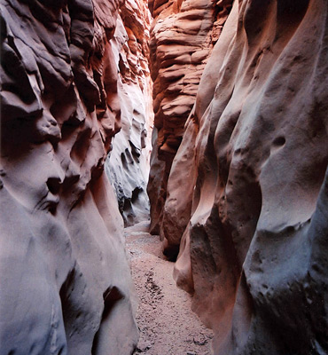
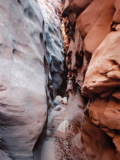
The upper parts have smooth walls made of thin, gently sloping strata which give way to more angular layers with knobbly intrusions, all in various subtle colors of red, orange and gray. The surrounding area, while largely empty, has various other points of interest including historical sites, canyons and unusual geology.
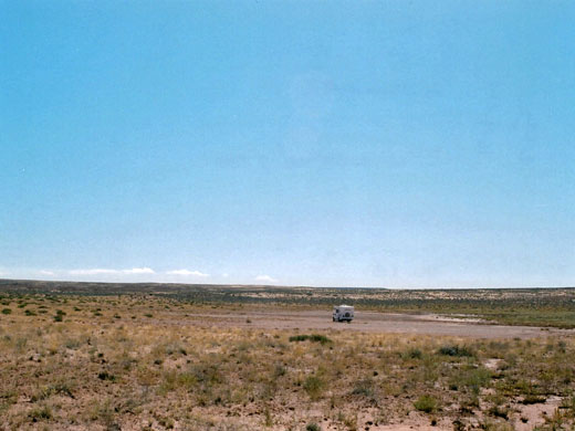
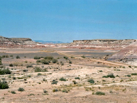
Moonshine Wash is a south side tributary of the San Rafael River, joining it just a few miles west of the Green River. Roads to this area are generally good and receive a fair amount of traffic though this is still a very remote region, mostly flat prairie without a tree or bush in sight, that allows for uninterrupted views over many square miles of the San Rafael Desert. Access to the Moonshine Wash canyon is by the Lower San Rafael Road (1010), a 70 mile unpaved route between the town of Green River and UT 24, which it joins near milepost 136, opposite the side road to Goblin Valley and the eastern San Rafael Swell. For the first 30 miles the road is relatively wide and the surface is smooth - hard pressed red dirt, though this may be impassable after heavy rains - and starts by heading due south, through grassy land and sand dunes. It turns 90° east in front of a ranch with a well and corral, climbs slightly and passes between the Little and Big Flat Top Buttes, ascends higher up the side of a sandy plateau then descends gradually to a major junction with map and information post. Right (south) leads to the Robbers Roost area and Hans Flat in the Maze section of Canyonlands National Park, while the main route continues to the left (north).
The road is narrower and more uneven along Little Antelope Valley, and soon passes another junction where a side road leaves to the east, towards the Horseshoe Canyon section of Canyonlands NP. This is followed by a long straightish section then, just after crossing the wash at the upper end of Three Canyon, reaches another signposted junction. The starting point for the hike to Moonshine Wash is one mile along the track on the left - this road crosses Saucer Basin, a circular depression surrounded by a ring of low hills, which has easy parking on mud flats and makes for an extremely peaceful place to camp as there is very little traffic along here.
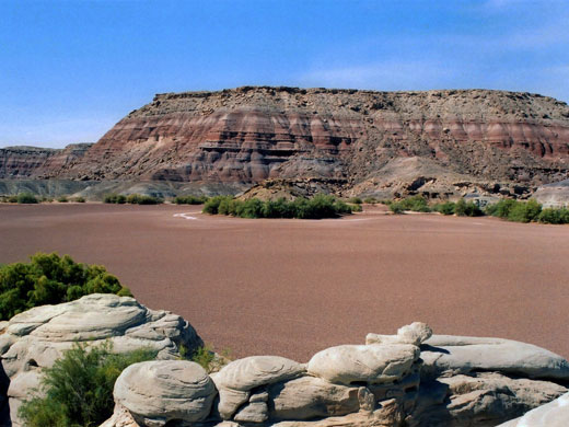
Continuing along the main track, the town of Green River is still about 30 miles away. From the Saucer Basin junction, the road is at first rather rough, as it approaches the San Rafael River, with a few sandy wash crossings and rocky sections. Once over the river, via a wide concrete bridge, the road becomes quite ridged (graded) for a few miles then is good again all the way the end; it climbs into grassy hills (Horse Bench), round a big side canyon and into stark, eroded badlands of the Chine Formation. One notable area is the (usually) dry Horse Bench Reservoir with a floor of pinkish mud - absolutely no vegetation here, after which the road traverses more dusty hillsides and mud flats to Green River. It rejoins tarmac when it meets Airport Road, which leads to Center Street in the middle of town.
22 views of Moonshine Wash.
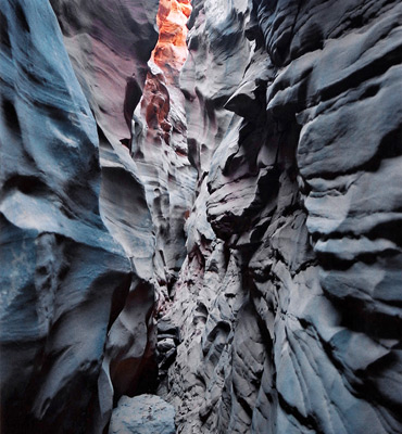
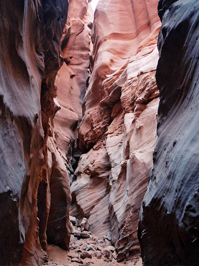
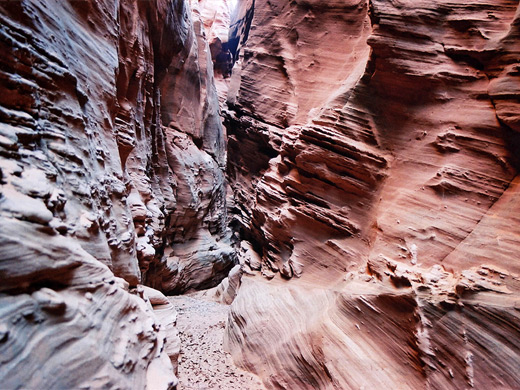
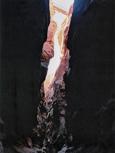
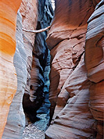
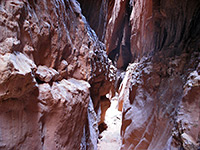
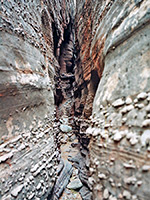
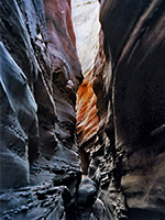
The canyon of Moonshine Wash is about 1.5 miles from the parking area in Saucer Basin, and is reached by walking a little west of due north, heading first towards the left side of the most prominent peak of a small rocky outcrop at the edge of the basin, from where the drainage is visible in the distance, then continuing along small washes and past sandy mounds to the streambed. At this point, Moonshine has stepped sandstone walls and quite a wide sandy floor but becomes a slot canyon just one mile downstream. The shallow narrows deepen steadily via a few chokestones and drops of up to 3 meters, sometimes above pools - obstructions that are moderately difficult to pass, and rather more so if returning upcanyon. The canyon is soon deep, narrow and impressive, and has long, very pretty curving passages formed of Navajo sandstone that changes in character half way through, from being smooth to having jagged ridges and angled strata, which make the passages even more photogenic and interesting.
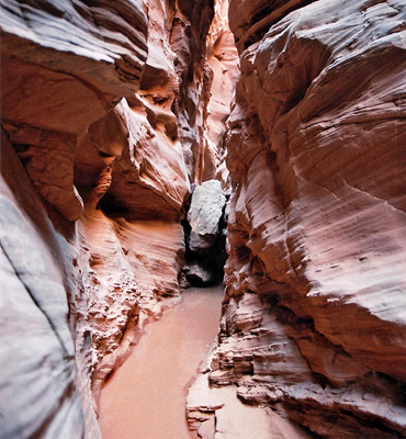
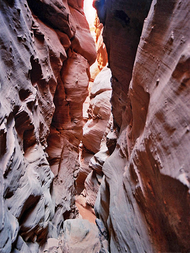
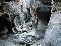
If rain has recently fallen then pools will be more frequent further down the canyon, up to 4 feet in depth and with long patches of slippery mud in between. High above the deepest point of the canyon is a wooden sheep bridge dating from the early nineteenth century, which marks the end of the best narrows, as soon after the canyon widens a bit to a section with larger pools and deeper mud, then changes quite abruptly around a bend into a box canyon, once more with a flat sandy floor, but now 200 feet deep.
The left (west) fork joins after half a mile more; a similar size canyon but without extensive narrows, this has one short entrenched channel that empties over a dryfall into a deep pool. One worthwhile side trip is to Moonshine Spring, a little way up this left fork, where springs create a long, shallow, cold, clear pool fed by a dripping cascade - a good place to cool off in hot weather. Around here are old concrete structures and pipes, relics of the whiskey distilling activities that gave the wash its name. This area can be reached by walking back down the main (right) fork of Moonshine for about 100 meters then climbing a steep slope on the west side to the empty plateau above, and finally across a sandy ridge to the next drainage. The route back to the trailhead is then cross-country for ca. 2 miles, crossing the main fork again some way upstream of the narrows. A round trip takes from four hours.
The upper parts have smooth walls made of thin, gently sloping strata which give way to more angular layers with knobbly intrusions, all in various subtle colors of red, orange and gray. The surrounding area, while largely empty, has various other points of interest including historical sites, canyons and unusual geology.
Location
Moonshine Wash is a south side tributary of the San Rafael River, joining it just a few miles west of the Green River. Roads to this area are generally good and receive a fair amount of traffic though this is still a very remote region, mostly flat prairie without a tree or bush in sight, that allows for uninterrupted views over many square miles of the San Rafael Desert. Access to the Moonshine Wash canyon is by the Lower San Rafael Road (1010), a 70 mile unpaved route between the town of Green River and UT 24, which it joins near milepost 136, opposite the side road to Goblin Valley and the eastern San Rafael Swell. For the first 30 miles the road is relatively wide and the surface is smooth - hard pressed red dirt, though this may be impassable after heavy rains - and starts by heading due south, through grassy land and sand dunes. It turns 90° east in front of a ranch with a well and corral, climbs slightly and passes between the Little and Big Flat Top Buttes, ascends higher up the side of a sandy plateau then descends gradually to a major junction with map and information post. Right (south) leads to the Robbers Roost area and Hans Flat in the Maze section of Canyonlands National Park, while the main route continues to the left (north).
Saucer Basin
The road is narrower and more uneven along Little Antelope Valley, and soon passes another junction where a side road leaves to the east, towards the Horseshoe Canyon section of Canyonlands NP. This is followed by a long straightish section then, just after crossing the wash at the upper end of Three Canyon, reaches another signposted junction. The starting point for the hike to Moonshine Wash is one mile along the track on the left - this road crosses Saucer Basin, a circular depression surrounded by a ring of low hills, which has easy parking on mud flats and makes for an extremely peaceful place to camp as there is very little traffic along here.
San Rafael River
Continuing along the main track, the town of Green River is still about 30 miles away. From the Saucer Basin junction, the road is at first rather rough, as it approaches the San Rafael River, with a few sandy wash crossings and rocky sections. Once over the river, via a wide concrete bridge, the road becomes quite ridged (graded) for a few miles then is good again all the way the end; it climbs into grassy hills (Horse Bench), round a big side canyon and into stark, eroded badlands of the Chine Formation. One notable area is the (usually) dry Horse Bench Reservoir with a floor of pinkish mud - absolutely no vegetation here, after which the road traverses more dusty hillsides and mud flats to Green River. It rejoins tarmac when it meets Airport Road, which leads to Center Street in the middle of town.
Photographs
22 views of Moonshine Wash.
Moonshine Wash Route Description
The canyon of Moonshine Wash is about 1.5 miles from the parking area in Saucer Basin, and is reached by walking a little west of due north, heading first towards the left side of the most prominent peak of a small rocky outcrop at the edge of the basin, from where the drainage is visible in the distance, then continuing along small washes and past sandy mounds to the streambed. At this point, Moonshine has stepped sandstone walls and quite a wide sandy floor but becomes a slot canyon just one mile downstream. The shallow narrows deepen steadily via a few chokestones and drops of up to 3 meters, sometimes above pools - obstructions that are moderately difficult to pass, and rather more so if returning upcanyon. The canyon is soon deep, narrow and impressive, and has long, very pretty curving passages formed of Navajo sandstone that changes in character half way through, from being smooth to having jagged ridges and angled strata, which make the passages even more photogenic and interesting.
Pools
If rain has recently fallen then pools will be more frequent further down the canyon, up to 4 feet in depth and with long patches of slippery mud in between. High above the deepest point of the canyon is a wooden sheep bridge dating from the early nineteenth century, which marks the end of the best narrows, as soon after the canyon widens a bit to a section with larger pools and deeper mud, then changes quite abruptly around a bend into a box canyon, once more with a flat sandy floor, but now 200 feet deep.
West Fork of Moonshine Wash
The left (west) fork joins after half a mile more; a similar size canyon but without extensive narrows, this has one short entrenched channel that empties over a dryfall into a deep pool. One worthwhile side trip is to Moonshine Spring, a little way up this left fork, where springs create a long, shallow, cold, clear pool fed by a dripping cascade - a good place to cool off in hot weather. Around here are old concrete structures and pipes, relics of the whiskey distilling activities that gave the wash its name. This area can be reached by walking back down the main (right) fork of Moonshine for about 100 meters then climbing a steep slope on the west side to the empty plateau above, and finally across a sandy ridge to the next drainage. The route back to the trailhead is then cross-country for ca. 2 miles, crossing the main fork again some way upstream of the narrows. A round trip takes from four hours.
Moonshine Wash is one of the top 25 slot canyons
Moonshine Wash - Similar Hikes
All Contents © Copyright The American Southwest | Comments and Questions | Contribute | Affiliate Marketing Disclosure | Site Map