Blue John Canyon
Deep, branched slots in a remote but scenic region near the Green River and Canyonlands NP. Some parts require rappelling and/or difficult downclimbing, to pass dryfalls of up to 70 feet, but most can be seen by hiking and scrambling. Easiest explored are the main and west forks
Length: 8 miles, round trip - down the west fork, up the main fork to the steep part, then back cross-country to the start. Several other routes possible
Difficulty: Moderate
Management: BLM
Rocks: Navajo sandstone
Season: Spring, summer, fall
Trailhead: Side track north of Burr Pass. Three other possible start points
Rating (1-5): ★★★★★
Difficulty: Moderate
Management: BLM
Rocks: Navajo sandstone
Season: Spring, summer, fall
Trailhead: Side track north of Burr Pass. Three other possible start points
Rating (1-5): ★★★★★

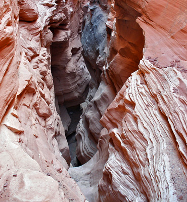
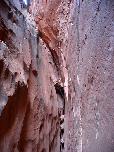
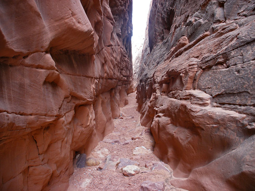
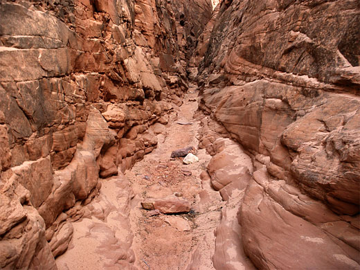
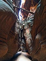
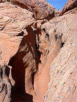
The narrows of Blue John Canyon are some of the best anywhere in the Southwest, offering a range of canyoneering challenges to suit all levels; there are deep but obstruction-free slots, watery potholes, steeply descending sections requiring difficult downclimbing, and several sheer drops where rappelling is needed. The drainage forks several times, into three main branches that each have narrows, and all with short side canyons that also form tight slots, so 2 or 3 days would be necessary to see all parts.
Although the canyon has become fairly well known in recent years, partly because of Aron Ralston, its remote location means that still relatively few people visit, and the narrows can usually be enjoyed in solitude. Blue John Canyon is a tributary of Horseshoe Canyon (Barrier Creek), a long drainage that is famous for several well preserved sets of petroglyphs found 4 miles downstream of the junction, contained within a detached unit of Canyonlands National Park. This canyon eventually joins the Green River, but Blue John is considered to be part of the Robbers Roost area, a remote land once frequented by Butch Cassidy, and centered on the numerous, branched east side tributaries of the Dirty Devil River, many of which also form deep slot canyons.
Overview map of Blue John Canyon, TopoQuest topographic map.
25 views of Blue John Canyon (west/main forks), and a short video (5.4 mb).
Details of the route along the West and Main Forks of Blue John Canyon.
Blue John Canyon may be reached either from the north starting at Green River, or from the west beginning at UT 24 half way between Hanksville and I-70; the two points are linked by the unpaved, 70 mile San Rafael Road (FR 1010), which although crossing very remote, uninhabited country, is well maintained, generally fine for regular cars, and receives a fair amount of traffic, mostly to the Horseshoe Canyon and Maze districts of Canyonlands National Park. The western part of the route is the preferred approach; this starts near milepost 136 of UT 24, just south of the turn-off on the opposite side to Goblin Valley State Park, and at first heads south, across an area of sand dunes to a corral at Jeffery Well, where the road turns east, passing between the Little and Big Flat Top buttes and climbing up to the top of a wide mesa.
From here the track crosses more wide-open, treeless country to a major junction, marked by an NPS notice board bearing a topographic map of the area plus information about hiking in Canyonlands and the Blue John complex. Horseshoe Canyon (and other interesting sites such as Moonshine Wash) are north, further along FR 1010, while the Maze and the Blue John Canyons are south. The road south is a bit narrower than the main route, and more bumpy, though still fine for all vehicles except after heavy rain, which is liable to make all roads in the area impassable for several hours until the surface dries up. The track crosses a wide basin (Antelope Valley) and climbs gradually, reaching Burr Pass after 7 miles - this is the highest point around and gives the first good views of Blue John Canyon and other narrow ravines to the east.
There are at least four possible start points for exploring the Blue John Canyon system (see map). Easiest-reached is a half a mile before Burr Pass, where a sandy track joins from the east; near the junction are several places to park/camp, beside a few trees that provide some shade. A second place, for 4WD vehicles, is half a mile down this track, where it crosses the upper west fork of the canyon. Third is a half mile south of Burr Pass, just after a west-side junction, at a parking area by the side of the road - start of a cross-country route to the top of the narrows of the main fork. The final option, 1.5 miles further south, is at the end of a short side track to Granary Spring, also a good camping spot. From here, the beginning of the narrows of the east fork lies 3 miles away to the east.
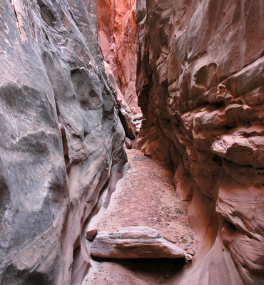
The three main branches of Blue John Canyon all have a similar layout, of a shallow wash that drops steeply down into a narrow slot, widening gradually and offering easy entry/exit routes once the enclosing cliffs recede. The two principal forks are main and east; both can be explored from the top with some difficult downclimbing and/or rappelling, or from the lower end via a longer hike that involves retracing steps when the steep part is reached.
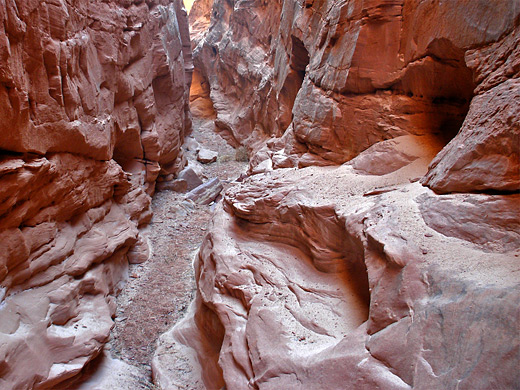
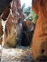
West Fork - this is quite shallow, forming just one enclosed section about 1/4 mile in length, at the start of which is a steep place needing moderate downclimbing. The drainage is often used as an exit route after descending the main or east forks.
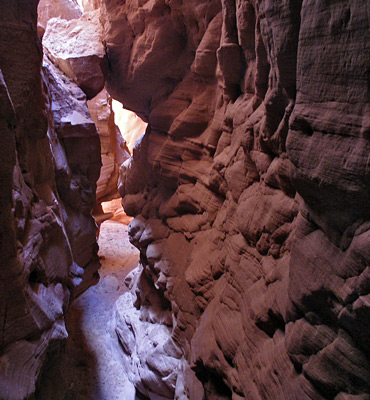
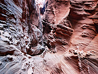
Main Fork - one mile of the main fork forms a deep, narrow canyon, and a quarter of this is a dark slot. The upper end descends steeply, by 100 feet over a distance of about 200 feet, so is easiest to explore in the downstream direction though even here a rope may be needed.
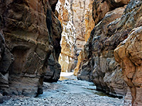
East Fork - the eastern branch is the longest, and its upper end has a lengthy narrow section, in the middle of which are a number of deep potholes and several dryfalls. The best part of the slot is below these obstacles.
Lower Canyon - north of the junction of all the upper forks, Blue John is a wide, sandy drainage but narrows once more to a good, dark, steeply-descending slot just before a big drop off (70 feet). It was here that Aron Ralston became entrapped by a large boulder and after five days resorted to severing his arm with a pocket knife. After the dryfall the drainage becomes a wide, sandy-floored box canyon, and remains similar in appearance all the way to the confluence with Horseshoe Canyon and then the Green River.
Although the canyon has become fairly well known in recent years, partly because of Aron Ralston, its remote location means that still relatively few people visit, and the narrows can usually be enjoyed in solitude. Blue John Canyon is a tributary of Horseshoe Canyon (Barrier Creek), a long drainage that is famous for several well preserved sets of petroglyphs found 4 miles downstream of the junction, contained within a detached unit of Canyonlands National Park. This canyon eventually joins the Green River, but Blue John is considered to be part of the Robbers Roost area, a remote land once frequented by Butch Cassidy, and centered on the numerous, branched east side tributaries of the Dirty Devil River, many of which also form deep slot canyons.
Maps
Overview map of Blue John Canyon, TopoQuest topographic map.
Photographs
25 views of Blue John Canyon (west/main forks), and a short video (5.4 mb).
Route Description
Details of the route along the West and Main Forks of Blue John Canyon.

Location
Blue John Canyon may be reached either from the north starting at Green River, or from the west beginning at UT 24 half way between Hanksville and I-70; the two points are linked by the unpaved, 70 mile San Rafael Road (FR 1010), which although crossing very remote, uninhabited country, is well maintained, generally fine for regular cars, and receives a fair amount of traffic, mostly to the Horseshoe Canyon and Maze districts of Canyonlands National Park. The western part of the route is the preferred approach; this starts near milepost 136 of UT 24, just south of the turn-off on the opposite side to Goblin Valley State Park, and at first heads south, across an area of sand dunes to a corral at Jeffery Well, where the road turns east, passing between the Little and Big Flat Top buttes and climbing up to the top of a wide mesa.

The Approach Track
From here the track crosses more wide-open, treeless country to a major junction, marked by an NPS notice board bearing a topographic map of the area plus information about hiking in Canyonlands and the Blue John complex. Horseshoe Canyon (and other interesting sites such as Moonshine Wash) are north, further along FR 1010, while the Maze and the Blue John Canyons are south. The road south is a bit narrower than the main route, and more bumpy, though still fine for all vehicles except after heavy rain, which is liable to make all roads in the area impassable for several hours until the surface dries up. The track crosses a wide basin (Antelope Valley) and climbs gradually, reaching Burr Pass after 7 miles - this is the highest point around and gives the first good views of Blue John Canyon and other narrow ravines to the east.

Access Points
There are at least four possible start points for exploring the Blue John Canyon system (see map). Easiest-reached is a half a mile before Burr Pass, where a sandy track joins from the east; near the junction are several places to park/camp, beside a few trees that provide some shade. A second place, for 4WD vehicles, is half a mile down this track, where it crosses the upper west fork of the canyon. Third is a half mile south of Burr Pass, just after a west-side junction, at a parking area by the side of the road - start of a cross-country route to the top of the narrows of the main fork. The final option, 1.5 miles further south, is at the end of a short side track to Granary Spring, also a good camping spot. From here, the beginning of the narrows of the east fork lies 3 miles away to the east.
Branches of Blue John Canyon
The three main branches of Blue John Canyon all have a similar layout, of a shallow wash that drops steeply down into a narrow slot, widening gradually and offering easy entry/exit routes once the enclosing cliffs recede. The two principal forks are main and east; both can be explored from the top with some difficult downclimbing and/or rappelling, or from the lower end via a longer hike that involves retracing steps when the steep part is reached.
West Fork - this is quite shallow, forming just one enclosed section about 1/4 mile in length, at the start of which is a steep place needing moderate downclimbing. The drainage is often used as an exit route after descending the main or east forks.
Main Fork - one mile of the main fork forms a deep, narrow canyon, and a quarter of this is a dark slot. The upper end descends steeply, by 100 feet over a distance of about 200 feet, so is easiest to explore in the downstream direction though even here a rope may be needed.
East Fork - the eastern branch is the longest, and its upper end has a lengthy narrow section, in the middle of which are a number of deep potholes and several dryfalls. The best part of the slot is below these obstacles.
Lower Canyon - north of the junction of all the upper forks, Blue John is a wide, sandy drainage but narrows once more to a good, dark, steeply-descending slot just before a big drop off (70 feet). It was here that Aron Ralston became entrapped by a large boulder and after five days resorted to severing his arm with a pocket knife. After the dryfall the drainage becomes a wide, sandy-floored box canyon, and remains similar in appearance all the way to the confluence with Horseshoe Canyon and then the Green River.

Blue John Canyon is one of the top 25 slot canyons
Blue John Canyon - Similar Hikes
All Contents © Copyright The American Southwest | Comments and Questions | Contribute | Affiliate Marketing Disclosure | Site Map