White House Ruin Trail, Canyon de Chelly National Monument
Arizona > Canyon de Chelly National Monument > White House Ruin Trail
White House Ruin Trail
The only route open to unaccompanied hikers; the trail descends quite steeply to the canyon floor, crosses Chinle Wash and continues a short distance to a famous ruin at the base of the cliffs on the north side of the ravine. Currently closed, however
Length: 1.2 miles
Elevation change: 560 feet
Difficulty: Easy to moderate
Type: One way
Usage: High
Season: All year
Trailhead: White House Overlook, along the South Rim Drive
Rating (1-5): ★★★★★
Download route (kmz)
Elevation change: 560 feet
Difficulty: Easy to moderate
Type: One way
Usage: High
Season: All year
Trailhead: White House Overlook, along the South Rim Drive
Rating (1-5): ★★★★★
Download route (kmz)
Note: the White House Ruin Trail has been closed since March 2020 because of repeated break-ins at the trailhead
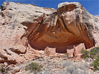
There are several dozen paths into the three main ravines in Canyon de Chelly National Monument, all ancient Navajo routes in use for centuries, but only one is open to unaccompanied hikers - this is the White House Ruin Trail, which descends nearly 600 feet down the cliffs on the south side of Canyon de Chelly, crosses the seasonal Chinle Wash and ends beside one of the most famous ancient dwellings in the monument, a two-level structure with one part on the valley floor and the other 50 feet up in an alcove. All other paths in the monument require permits and guides; there are approximately 14 such routes, along either the south side of Canyon de Chelly or the north side of Canyon del Muerto.
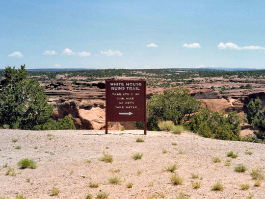
The White House Ruin Trail begins at an overlook at the end of a short spur road, 7 miles east of Chinle - an often busy place, with space for several dozen vehicles. For those not hiking the trail, a walk of just 350 feet reaches the overlook, which has a good view of the ruins, 2,000 feet east, plus another, smaller structure nearly opposite. Typical round trip times for the trail are 1 to 2 hours, and the path is wide, well-used and not too steep.
Canyon de Chelly map, showing roads, ruins and overlooks.
The trail starts off due south, running along the canyon edge for a short distance then dropping below the rim, down the uppermost section of the cliffs, to a bushy bench, followed by a short series of switchbacks descending a boulder-covered slope, close to bigger cliffs to the north. The final switchback curves around a slickrock bowl, the lowest segment of the main cliffs, and ahead the land is more gently sloping, and sandy. The trail now moves northwards, descending into a little ravine, passing at two points through short tunnels, and emerging to the flat land beside Chinle Wash. Near the lower end, just before the second tunnel, the path takes an interesting short-cut down a narrow gully, using old foot-holes carved in the sandstone walls.
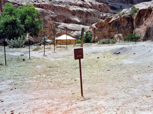
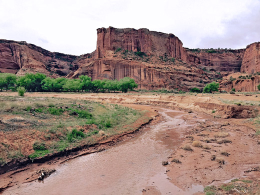
On the valley floor, a huge protruding rock rises 560 feet directly ahead, inside a U-bend along the wash, while to the south is a line of trees and a sizeable cultivated area. This has fences, fields, an orchard and a hogan, but all is off-limits to hikers, and a sign directs people away to the north, along the base of cliffs which soon become very tall and sheer. The path then crosses the wash on a footbridge and follows the east bank for a quarter of a mile to the ruins. Once at the White House, rest rooms and Indian jewelry sellers detract a little from the experience but the delicate well-preserved buildings beneath the sheer, desert varnish-streaked, cliff are well worth the trip.
Construction of the buildings at the White House site began around 1070, and the place is thought to have been abandoned in the late 1300s. The name derives from a whitish band across the nearby cliffs. The lower ruin, on the canyon floor, once comprised around 60 rooms, while the upper, alcove site has 20, including four kivas; together, the dwellings were home to at least 50 people. Only around half of the lower ruin is visible today; the remainder was washed away as a result of several years of unusually high rainfall in the 1910s. Excavations in the 19th and 20th centuries revealed burial sites, tools, projectile points and large amounts of pottery including several complete items.
There are several dozen paths into the three main ravines in Canyon de Chelly National Monument, all ancient Navajo routes in use for centuries, but only one is open to unaccompanied hikers - this is the White House Ruin Trail, which descends nearly 600 feet down the cliffs on the south side of Canyon de Chelly, crosses the seasonal Chinle Wash and ends beside one of the most famous ancient dwellings in the monument, a two-level structure with one part on the valley floor and the other 50 feet up in an alcove. All other paths in the monument require permits and guides; there are approximately 14 such routes, along either the south side of Canyon de Chelly or the north side of Canyon del Muerto.
The White House Ruin Trail begins at an overlook at the end of a short spur road, 7 miles east of Chinle - an often busy place, with space for several dozen vehicles. For those not hiking the trail, a walk of just 350 feet reaches the overlook, which has a good view of the ruins, 2,000 feet east, plus another, smaller structure nearly opposite. Typical round trip times for the trail are 1 to 2 hours, and the path is wide, well-used and not too steep.
Location
Canyon de Chelly map, showing roads, ruins and overlooks.
The Trail
The trail starts off due south, running along the canyon edge for a short distance then dropping below the rim, down the uppermost section of the cliffs, to a bushy bench, followed by a short series of switchbacks descending a boulder-covered slope, close to bigger cliffs to the north. The final switchback curves around a slickrock bowl, the lowest segment of the main cliffs, and ahead the land is more gently sloping, and sandy. The trail now moves northwards, descending into a little ravine, passing at two points through short tunnels, and emerging to the flat land beside Chinle Wash. Near the lower end, just before the second tunnel, the path takes an interesting short-cut down a narrow gully, using old foot-holes carved in the sandstone walls.
The Canyon Floor
On the valley floor, a huge protruding rock rises 560 feet directly ahead, inside a U-bend along the wash, while to the south is a line of trees and a sizeable cultivated area. This has fences, fields, an orchard and a hogan, but all is off-limits to hikers, and a sign directs people away to the north, along the base of cliffs which soon become very tall and sheer. The path then crosses the wash on a footbridge and follows the east bank for a quarter of a mile to the ruins. Once at the White House, rest rooms and Indian jewelry sellers detract a little from the experience but the delicate well-preserved buildings beneath the sheer, desert varnish-streaked, cliff are well worth the trip.
The White House Ruins
Construction of the buildings at the White House site began around 1070, and the place is thought to have been abandoned in the late 1300s. The name derives from a whitish band across the nearby cliffs. The lower ruin, on the canyon floor, once comprised around 60 rooms, while the upper, alcove site has 20, including four kivas; together, the dwellings were home to at least 50 people. Only around half of the lower ruin is visible today; the remainder was washed away as a result of several years of unusually high rainfall in the 1910s. Excavations in the 19th and 20th centuries revealed burial sites, tools, projectile points and large amounts of pottery including several complete items.
White House Ruin Trail - Similar Hikes
All Contents © Copyright The American Southwest | Comments and Questions | Contribute | Affiliate Marketing Disclosure | Site Map


