Canyon Viewpoints in Black Canyon of the Gunnison National Park
Colorado > Black Canyon of the Gunnison National Park > Canyon Viewpoints
Jump to North Rim viewpoints.
South Rim Viewpoints
The first glimpse of Black Canyon for South Rim visitors is at Tomichi Point, an east-facing overlook that may be a slight disappointment to some as the canyon here is not particularly steep, the profile V-shaped rather than sheer-walled, and the Gunnison River is not properly in view, being hidden behind a fold in the cliffs. The course of the canyon still can be traced for some distance eastwards though, enclosed by undulating, green, wooded hills. The overlook is right beside the road so no hiking is necessary.
The second viewpoint, Gunnison Point, is the most popular in the park as it lies just behind the visitor center, linked to Tomichi Point and the campground by a one mile trail along the rim. A short path descends some steps and splits, both branches leading to viewpoints at the tips of a small promontory. The main view is northwards, across the canyon, which is now much narrower and more dramatic than at Tomichi Point. Directly opposite are two steep gullies, separated by vertically fractured cliffs split by many thin, light-colored pegmatite dikes. Also in view is a narrow ravine on the south side, course of the Gunnison Route down to the river.
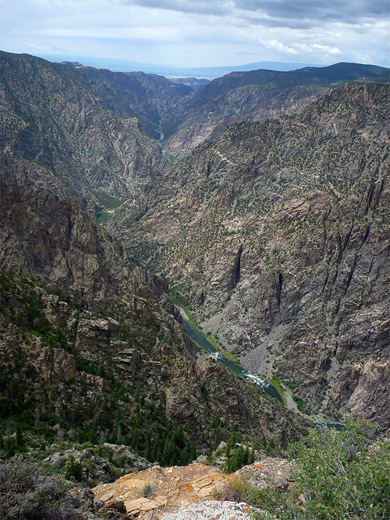
Two miles further along the road, the next stop is Pulpit Rock Overlook, where even more of the river is in view, as it curves round a 90 degree bend. A 134 yard trail leads to the viewing area, where the best aspect is upstream, a straight section of the canyon bordered to the south by smooth slopes covered by a mix of scree and vegetation, in contrast to the opposite side of the valley which is much rockier and more rugged.
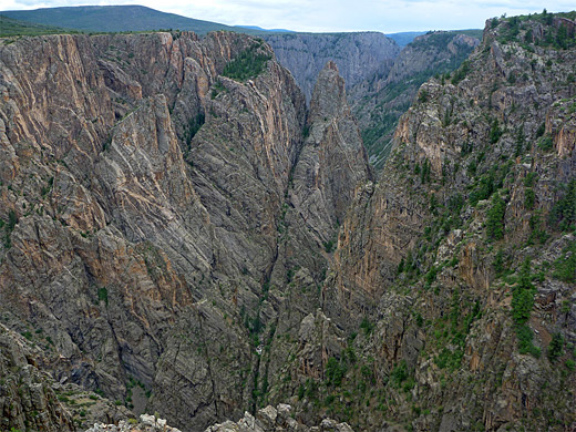
The park road rounds several tight bends before passing the parking area for Cross Fissures View, reached by a 357 yard path. Here the river is not visible and most of the canyon is obscured, concealed by a detached section of the rim immediately north. Instead the views are of overlapping ridges and crevasses at different angles, all plunging steeply downwards.
Fewer people stop at the next overlook, Rock Point, as the path to it is slightly longer (294 yards). It leads to a viewpoint about half way along a narrow, bushy promontory that continues after an impassable gully and hides most of the river, but some parts are in view to the left and right, including the junction with Long Draw, a very steep north-side tributary that provides a course for one of the rim to river hiking routes.
Beyond Rock Point, adjacent Devils Lookout is reached by another of the lengthier paths (607 yards) along a promontory, so again relatively few visitors come here. The trail goes right to the edge of the rim so the views are better, including part of the river, and the North Rim entrance road, winding down a shallow, grassy valley. Both this and Rock Point lie above the narrowest part of the whole canyon though this cannot properly be appreciated here because of the intervening rocks; the best viewpoint is from Narrows View on the North Rim.
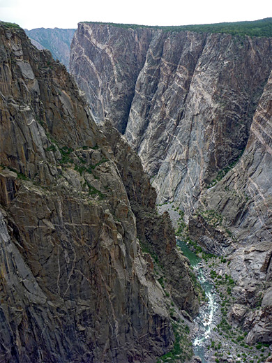
Chasm View is one of the most spectacular overlooks in the park. A very short path descends slightly to a sizeable, railing protected viewing area above perhaps the steepest part of the whole canyon, where the cliffs fall 1,840 feet over a horizontal distance of just 400 feet. The opposite wall is also very steep, crossed by more of the thin, branched volcanic dykes. Two ravines cut northwards at either side, the westerly (SOB Draw), used for another one of the rim to river hiking routes.
The river changes course just beyond Chasm View, bending to the southwest, therefore the next viewpoint, Painted Wall View, has quite a different panorama. The two overlooks are almost adjacent, so many people walk from one to the other. Painted Wall is the highest cliff in Colorado, bordering the far side of the river; a 2,250 foot wall of rock about half a mile across. This marks the end of the most enclosed part of Black Canyon since downstream the sides, although becoming even higher, are noticeably less steep, and more overgrown.
At Cedar Point, an 303 yard path heads west from the parking area to an overlook of the lower canyon; 1.5 miles of the river are in view, flowing over rapids, and edged by pebble beaches and patches of greenery. The V-shaped canyon curves northwards out of sight, as the valley sides start to recede.
Views from nearby Dragon Point are very similar; a widening ravine with overgrown sides, enclosing the greenish-grey waters of the river. The overlook is reached by a wide path across a flat, rocky promontory between the river and a small side canyon to the south. A sign gives the distance as 100 yards but 300 is more accurate.
Sunset View, the westernmost viewpoint along the South Rim road, is accompanied by quite a large parking area with picnic tables and a restroom. The perspective down the canyon is more to the northwest, and although the closest part of the river is partially obscured, more of the downstream section is visible for the first time, all the way to the Uncompahgre River valley in the far distance. The canyon walls directly below are still steep but not as nearly sheer as upstream, and trees grow all the way down to the river in some places. Past Sunset View, the road continues another mile to High Point, which also has picnic tables but no views of note.
Most people come to High Point for the 1,373 yard trail to Warner Point, the furthest overlook on the South Rim, which is now more of a promontory than a mesa since the land falls away on both sides, north and south. The trail starts off through flat woodland then steps down to a saddle giving views of green fields, 1,000 feet below to the south (Bostwick Park), with the city of Delta visible in the hazy distance beyond. The route climbs some more steps, passes through a thin patch of trees and rounds a corner - some good views of the canyon here - then drops down to a lesser saddle and briefly ascends the far side, before curving northwards to the final viewpoint. This has a 270 degree view of the lower canyon and some of the river, the best direction being upstream.
North Rim Viewpoints
The westernmost North Rim overlook is Exclamation Point, reached by a spur off the North Vista Trail, but the first usually visited, close to the road, is Chasm View, actually two separate locations along a 0.4 mile loop trail, beginning at the campground. The path runs right along the rim for a short distance, giving an amazing, unobstructed panorama directly down to the Gunnison River, 1,840 feet below. About a mile of the river is in full view, flowing through one of the narrowest parts of Black Canyon.
East of Chasm View, the park road bends northwards to avoid several tributary ravines, returning to the rim at Narrows View, above the end of the most enclosed section of the gorge, where the two rims are separated by as little as 750 feet. The best views here are upstream, to the southeast.
The scenery is similar at the next overlook not far beyond, Balanced Rock View, which has views across to several very steep tributaries on the south side, and one (Long Draw) adjacent, down which runs one of the three unmaintained North Rim river trails.
At Big Island View the upstream canyon is somewhat wider, the valley sides less steep, but also more varied, partly wooded and split by intermediate ravines. Again plenty of the river is visible, rushing through many whitewater sections over semi-submerged boulders. The overlook also gives a good vista of the lower end of the Narrows to the west, where the cliffs are at their most vertical.
The road curves round another side gully to Island Peaks View, where the spitting of the cliffs is even more apparent, and the river is mostly hidden behind a series of partly wooded, vertical-sided ridges between the rim and the main canyon, one of the best and most unusual viewpoints in the park.
The final overlook, one mile further, is Kneeling Camel View, right beside the road just before it ends. The overlook is bordered by angular rocks split by horizontal and vertical fractures; far below, the river bends due south, flowing between less steep slopes. At one point the location of the big landslide can be seen, where both sides of the river edged by screen slopes, were a temporary dam once formed. The westward view is also good, a mirror of Pulpit Rock Overlook on the south rim, with smooth, more gentle slopes on one side and much steeper, jagged cliffs opposite.
All Contents © Copyright The American Southwest | Comments and Questions | Contribute | Affiliate Marketing Disclosure | Site Map


