Highlights:
The different regions of the Grand Canyon; the North Rim, South Rim, Marble Canyon, Hualapai Reservation and Tuweep. The route also passes other nearby locations such as Zion, Lake Mead and Lake Powell
Type:
Loop, beginning at Las Vegas
Length:
1,235 miles, 1,990 km
Duration:
11 days minimum; 16 days or more with optional side trips
Seasons:
Late spring, summer and fall, since the North Rim is closed by snow during winter, though for extended hiking trips, summer is generally too hot
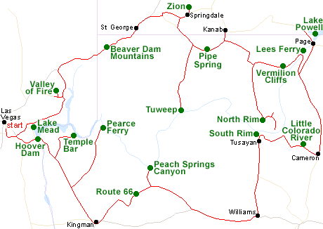
Map of the Grand Canyon Itinerary
Please refer to the disclosure notice for information about the affiliate (commissionable) links on this page.
Day 1 - Las Vegas to Kingman, 150 miles
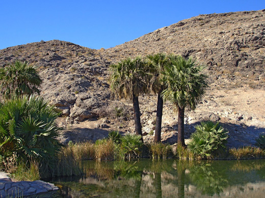
Hoover Dam is the first destination, just east of Las Vegas at the downstream end of Lake Mead. Another much less visited part of the lake is Temple Bar Marina, reached by a 25 mile side road forking off US 93; good for boat rentals or just relaxing by the shore. A longer road crosses Joshua tree forests to Pearce Ferry, at the far east side of the lake, and the lower end of the Grand Canyon, though low water levels in recent years has left this some distance from the water. Taking this side road instead would make for a total drive of 200 miles in the day.
Day 2 - Kingman to Williams, 215 miles
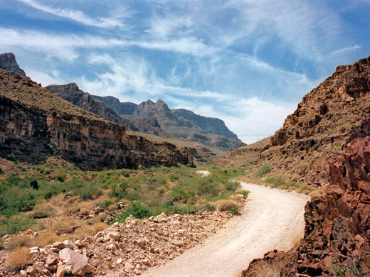
The direct way from Kingman to the South Rim of the Grand Canyon is via Interstate 40, but Route 66 provides a much more scenic alternative, crossing wide open lands, partly through the Hualapai Indian Reservation and the tribal town of Peach Springs. From here a very scenic unpaved track follows Peach Springs Canyon all the way to the Colorado River - the only such road in the Grand Canyon. The old highway meets I-40 at Seligman, from where Williams is 40 miles east.
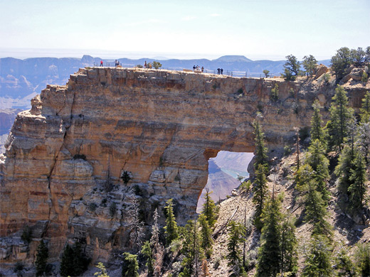
Optional extra day(s): Explore some of the Hualapai Indian Reservation backcountry - such remote places as Hindu Canyon, Milkweed Canyon and Meriwhitica Canyon. Also within the reservation is Grand Canyon Skywalk, but this is overpriced and not recommended. Another possibility is Havasu Canyon, deep within the adjacent Havasupai Indian Reservation. This can be visited in one day by strong hikers but most people camp for at least one night, or stay at an expensive lodge in the tribal town of Supai.
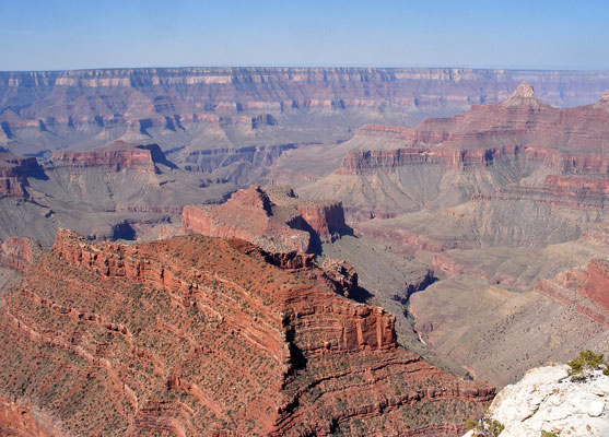
Day 3 - Williams to Grand Canyon South Rim, 70 miles
The South Rim of the Grand Canyon is an hour's drive north of Williams. Suggested activities for the first day are to see the western overlooks around Grand Canyon Village, ride the shuttle to Hermits Rest, and maybe take a short hike a little way down the South Kaibab or Bright Angel trails. The nearest chain lodging is just south of the park entrance at Tusayan.
Day 4 - Grand Canyon South Rim to Cameron, 60 miles
More viewpoints and trailheads are found along the 20 mile East Rim Drive; last is Desert View, before the highway turns away from the rim and descends into desert lands of the Navajo Indian Reservation, meeting US 89 near Cameron after passing close to the Little Colorado River. Good half day hikes along the rim drive include the first few miles of the Grandview, Tanner and Cedar Mountain trails.
Optional extra day: a longer hike into the canyon, maybe all the way to the Colorado River
Hotel: Cameron Trading Post
Day 5 - Cameron to Page, 100 miles
US 89 heads north across the Painted Desert, over the Echo Cliffs and on to Page, at the south end of Lake Powell in Glen Canyon NRA. Besides the lake itself, popular sites nearby include Antelope Canyon, Water Holes Canyon and Horseshoe Bend on the Colorado River.
Day 6 - Page to Grand Canyon North Rim, 130 miles
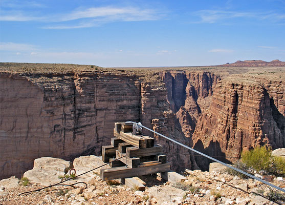
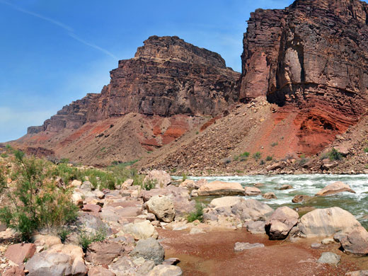
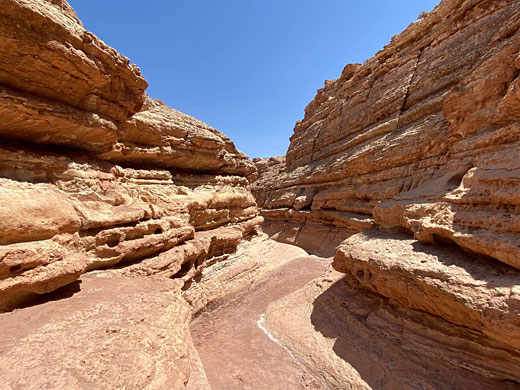
Lees Ferry is 40 miles from Page - a tiny settlement beside the Colorado River, at the very upper end of the Grand Canyon. Downstream, the river quickly becomes cliff-bound, and flows through a long narrow gorge (Marble Canyon), which can be viewed from the US 89 road bridge, or close up by hiking along various narrow tributaries such as Cathedral Wash or Jackass Creek. The road west runs along the base of the Vermilion Cliffs then climbs quite steeply up the densely wooded Kaibab Plateau to Jacob Lake, from where the North Rim of the Grand Canyon is 40 miles south.
Hotel: Grand Canyon Lodge, at the North Rim
Day 7 - North Rim of the Grand Canyon, 10 miles
Base for the first day at the North Rim is the end of the main road, near Grand Canyon Lodge; possible hikes include Widforss, Transept, Uncle Jim and North Kaibab.
Hotel: Grand Canyon Lodge, at the North Rim
Day 8 - North Rim to Kanab, 120 miles
Most of the day is spent exploring other parts of the North Rim, along the side road to Point Imperial and Cape Royal; here are a number of remote overlooks like Naji Point and Honan Point, plus a few trails; the 2 mile path to Cape Final is a good choice. The night is spent in Kanab in Utah, 80 miles from Grand Canyon Lodge.
Day 9 - Kanab to Springdale, 170 miles
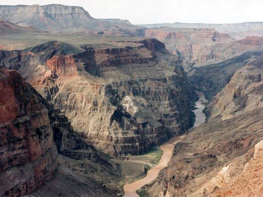
The road west from Kanab (Hwy 389) crosses empty lands of the Arizona Strip district, past Pipe Spring National Monument and then the turning for the long dirt track to Tuweep (or Toroweap), a spectacular, remote overlook of the western Grand Canyon. Many visitors camp for at least one night, but the point is still reachable on a day trip. The nearby Lava Falls Trail offers a short but very steep route down to the Colorado River. On returning to Hwy 389, the journey to Springdale is completed by a short cut along the scenic, unpaved Smithsonian Butte Road.
Optional extra day: more time at Tuweep
Day 10 - Springdale to St George, 40 miles
Most of the day is spent exploring Zion Canyon, the central attraction of Zion National Park, before driving west to St George. Good short trails in the canyon include Weeping Rock, Emerald Pools and Watchman.
Day 11 - St George to Las Vegas, 170 miles
The return to Las Vegas is initially via I-15 through the Beaver Dam Mountains, then along Northshore Road past Lake Mead, with a short side trip to the brilliantly colored rock formations of Valley of Fire State Park.
All Contents © Copyright The American Southwest | Comments and Questions | Contribute | Affiliate Marketing Disclosure | Site Map