Whitney Pocket Petroglyphs, Gold Butte National Monument
Nevada > Gold Butte National Monument > Whitney Pocket Petroglyphs
Whitney Pocket Petroglyphs
Many rock art panels, on cliffs and boulders, amidst colorful, eroded formations of Aztec sandstone, in the Mojave Desert north of Lake Mead
Length: about 2 miles, round trip
Elevation change: 100 feet
Difficulty: Moderate
Type: Partially off-trail
Usage: Low
Season: Fall, winter, spring
Trailhead: 1.9 miles south of Gold Butte Road, along a gravel track
Rating (1-5): ★★★★★
Elevation change: 100 feet
Difficulty: Moderate
Type: Partially off-trail
Usage: Low
Season: Fall, winter, spring
Trailhead: 1.9 miles south of Gold Butte Road, along a gravel track
Rating (1-5): ★★★★★

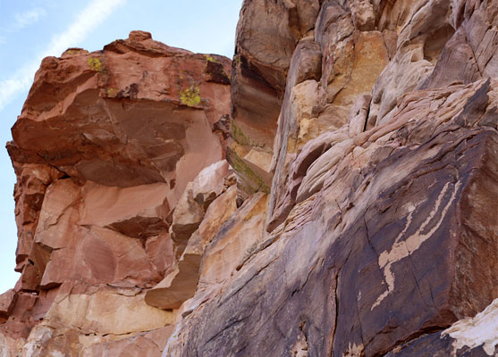
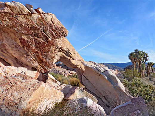
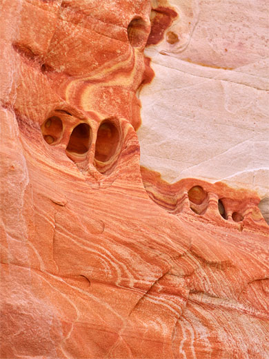
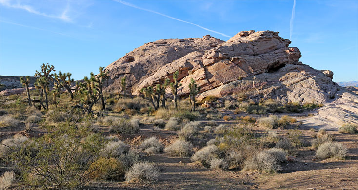
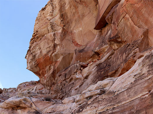
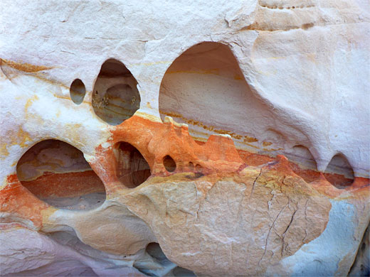
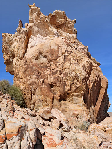
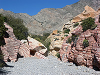
Aztec sandstone is a particularly colorful type of rock, formed of a lower unit, predominantly deep red, and an upper unit, variously white, yellow, pink and orange, often containing wavy bands and variegated patches of contrasting shades. The sandstone is exposed in many places in Gold Butte National Monument near Lake Mead, including in and around Whitney Pocket, a cluster of isolated outcrops surrounded by sandy plains. These outcrops are mainly of the lower, red unit, while close by to the southwest are larger exposures of the more colourful upper unit, extending over 3 miles; here are found arches, pinnacles and many other photogenic erosive features, in generally open terrain with wide-ranging views in all directions.
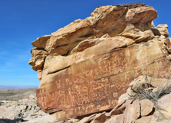
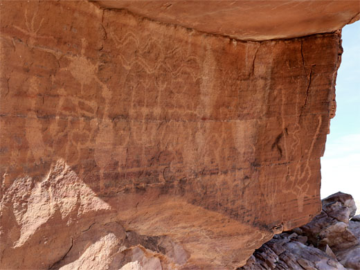
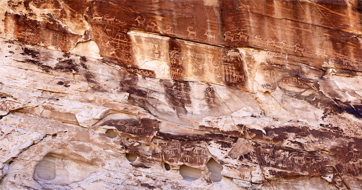
The area would be a fine hiking destination just for these reasons, but it has the added attraction of rock art; dozens of petroglyph panels and a few pictographs, on cliffs and boulders, the major concentration in an area just a quarter of a mile across, though the uneven terrain, the many little gullies and ridges, mean it can take some time to locate various panels. Several have semi-official names, including newspaper rock, a particularly fine grouping on a large boulder, and falling man, a single large figure on a taller cliff, while a bit further south is the 21 goats panel, depicting, amongst other items, a line of 21 (or more) bighorn sheep.
The rock art, and many sandstone formations, can be seen on a loop hike of about 2 miles, mostly along trails, with occasional minor scrambling up slopes to see some of the petroglyphs. Three to four hours is a typical time to explore the area.
The rock art is sometimes known as the Luke Whitney Petroglyphs, named after an early settler of this region, George 'Luke' Whitney, who moved here in 1910.
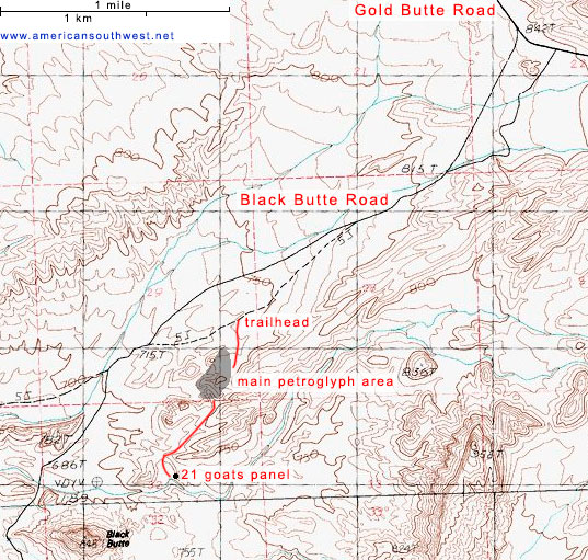
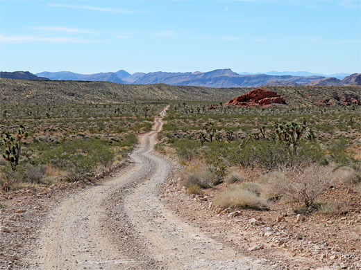
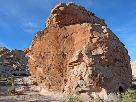
Whitney Pocket is reached by Gold Butte Road, which is mostly paved but the surface is old and damaged, so the drive is slow and bumpy. The petroglyphs are along a lesser track, Black Butte Road, forking south after 19.7 miles, in front of a red outcrop, shortly before the camping area at Whitney Pocket - down this narrow, stony road for 1.2 miles, over two dry washes, turning left at a junction (the right fork is rather less used) and on another 0.7 miles to a fenced parking place, in front of a pastel-colored sandstone butte, with large Joshua trees at its base.
A path, formerly a vehicle track, heads south from the parking place, round a little bend and on towards rabbit ears rock, so named for a pair of projecting pinnacles on top. At the base of one are some faint, reddish petroglyphs, viewable by a short climb up the slopes, while just to the north, a path heads west for 200 feet to Calvin's rock, which also has petroglyphs, numerous though rather faded. The rock is only recently named, in recognition of a member of the local Paiute tribe, Calvin Meyers (died 2013).
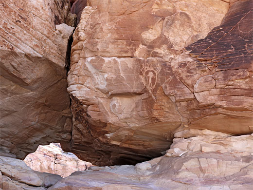
The old vehicle track ends south of rabbit ears rock, in front of some low cliffs. To the southwest is a little gully lined (to the east) by some particularly nice sandstone patterns, and at its far end the land slopes up to a small window, or cave, with petroglyphs on both sides of the opening. The rock here is all red, from the lower unit of the Aztec sandstone, part of a 200 foot-wide exposure which forms some taller, west-facing cliffs, and it is here that presumably a man once felt to his death, commemorated by the falling man figure, about 80 foot south of the small cave. Further west, the land is somewhat lower in elevation, the rocks mostly white, with many ravines and mounds.
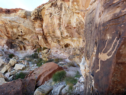
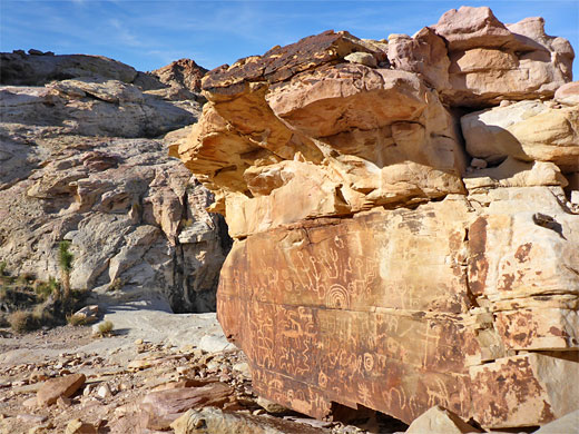
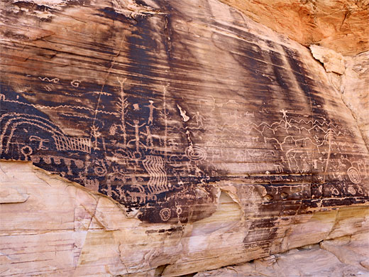
More petroglyphs can be found on the south side of the large butte containing the window and the falling man, including several spirals, while in the wider ravine to the southwest of the butte is newspaper rock, a boulder about 15 feet high, bearing perhaps the best panel in the area. On the south side of this ravine is another sizeable butte and at its base are more petroglyphs including two panels on the upper face of dropped boulders in alcoves - one has a range of shapes and spirals, the other a large foot. Nearby is 'the wall', a large grouping of designs, on several levels, this on the southwest side of the second butte. More are on the east side, including some bighorn sheep and a group of pinkish designs. A short cliff prevents a full walking circuit of this butte; one has to go part way round then back the other way, to see all the panels.
Beyond the second butte, the light-colored rock outcrops continue a short distance then fade away. A narrow but well-defined path leads southwest, across open ground with views of Black Butte, a darker peak half a mile ahead. The sandstone reappears, now more uniformly colored; off-white, generally less photogenic than before. The trail leads over some rocks and down into a shallow valley to the 21 goats panel, on a west-facing cliff with dark patina, the only such cliff hereabouts. The designs are numerous, crisp, and impressive. Just south, the valley meets a larger, sandy wash, used by ATVs; this drains westwards, past Black Butte, and intersects a continuation of the approach road, which, en route, has passed through a conservation area for the rare Las Vegas bearpoppy.
The area would be a fine hiking destination just for these reasons, but it has the added attraction of rock art; dozens of petroglyph panels and a few pictographs, on cliffs and boulders, the major concentration in an area just a quarter of a mile across, though the uneven terrain, the many little gullies and ridges, mean it can take some time to locate various panels. Several have semi-official names, including newspaper rock, a particularly fine grouping on a large boulder, and falling man, a single large figure on a taller cliff, while a bit further south is the 21 goats panel, depicting, amongst other items, a line of 21 (or more) bighorn sheep.
The rock art, and many sandstone formations, can be seen on a loop hike of about 2 miles, mostly along trails, with occasional minor scrambling up slopes to see some of the petroglyphs. Three to four hours is a typical time to explore the area.
The rock art is sometimes known as the Luke Whitney Petroglyphs, named after an early settler of this region, George 'Luke' Whitney, who moved here in 1910.
Trailhead
Whitney Pocket is reached by Gold Butte Road, which is mostly paved but the surface is old and damaged, so the drive is slow and bumpy. The petroglyphs are along a lesser track, Black Butte Road, forking south after 19.7 miles, in front of a red outcrop, shortly before the camping area at Whitney Pocket - down this narrow, stony road for 1.2 miles, over two dry washes, turning left at a junction (the right fork is rather less used) and on another 0.7 miles to a fenced parking place, in front of a pastel-colored sandstone butte, with large Joshua trees at its base.
Rabbit Ears Rock and Calvin's Rock
A path, formerly a vehicle track, heads south from the parking place, round a little bend and on towards rabbit ears rock, so named for a pair of projecting pinnacles on top. At the base of one are some faint, reddish petroglyphs, viewable by a short climb up the slopes, while just to the north, a path heads west for 200 feet to Calvin's rock, which also has petroglyphs, numerous though rather faded. The rock is only recently named, in recognition of a member of the local Paiute tribe, Calvin Meyers (died 2013).
Falling Man Area
The old vehicle track ends south of rabbit ears rock, in front of some low cliffs. To the southwest is a little gully lined (to the east) by some particularly nice sandstone patterns, and at its far end the land slopes up to a small window, or cave, with petroglyphs on both sides of the opening. The rock here is all red, from the lower unit of the Aztec sandstone, part of a 200 foot-wide exposure which forms some taller, west-facing cliffs, and it is here that presumably a man once felt to his death, commemorated by the falling man figure, about 80 foot south of the small cave. Further west, the land is somewhat lower in elevation, the rocks mostly white, with many ravines and mounds.
Newspaper Rock, and Other Panels
More petroglyphs can be found on the south side of the large butte containing the window and the falling man, including several spirals, while in the wider ravine to the southwest of the butte is newspaper rock, a boulder about 15 feet high, bearing perhaps the best panel in the area. On the south side of this ravine is another sizeable butte and at its base are more petroglyphs including two panels on the upper face of dropped boulders in alcoves - one has a range of shapes and spirals, the other a large foot. Nearby is 'the wall', a large grouping of designs, on several levels, this on the southwest side of the second butte. More are on the east side, including some bighorn sheep and a group of pinkish designs. A short cliff prevents a full walking circuit of this butte; one has to go part way round then back the other way, to see all the panels.
21 Goats
Beyond the second butte, the light-colored rock outcrops continue a short distance then fade away. A narrow but well-defined path leads southwest, across open ground with views of Black Butte, a darker peak half a mile ahead. The sandstone reappears, now more uniformly colored; off-white, generally less photogenic than before. The trail leads over some rocks and down into a shallow valley to the 21 goats panel, on a west-facing cliff with dark patina, the only such cliff hereabouts. The designs are numerous, crisp, and impressive. Just south, the valley meets a larger, sandy wash, used by ATVs; this drains westwards, past Black Butte, and intersects a continuation of the approach road, which, en route, has passed through a conservation area for the rare Las Vegas bearpoppy.
Topographic Map


Whitney Pocket Petroglyphs - Similar Hikes


All Contents © Copyright The American Southwest | Comments and Questions | Contribute | Affiliate Marketing Disclosure | Site Map