Highlights:
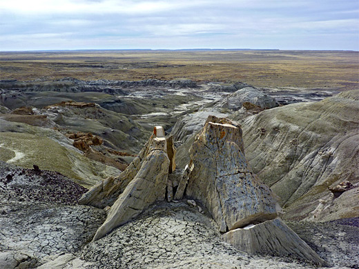
Remote region in the San Juan Basin of northwest New Mexico, containing hoodoos, balanced rocks, colorful mounds and petrified wood, including large, upright stumps
Nearby town:
Farmington, 50 miles
Management:
BLM
Location:
36.177, -108.077 (parking area)
Seasons:
All year, unless after heavy rain, as the access road may be impassable
Rating (1-5):
★★★★★
Within 20 miles of the large Bisti and De-Na-Zin wildernesses in the San Juan Basin of northwest New Mexico are other smaller, lesser known badland areas where the same multicolored sedimentary rocks are exposed and similar formations have been eroded. One outcrop 2 by 1 miles in extent occurs ten miles southeast and is known as the Fossil Forest on account of the large pieces of petrified wood found here, including long trunks and upright stumps.
The fossils are scattered along a ridge formed of undulating sandstone in subtle shades of grey, yellow and brown - resembling Ah-Shi-Sle-Pah further east - while other parts of the escarpment display more contrasting colors of red, white and black, this latter due to seams of coal. The region also has a scattering of hoodoos and balanced rocks, not particularly numerous but some are large and unusually shaped.
The Forest is quite compact, the best parts can be seen in just three hours or so and the place is quite easily reached, 5 miles from highway 371 on a good dirt track. Most of the formations are slightly elevated, and the slopes give long distance views over the surrounding flat, empty, high desert plains.
Fossil Forest Table of Contents
Location
Map of badlands in the San Juan Basin.
Photographs
25 views of the Fossil Forest.
Access to the Fossil Forest
County road 7650 leads close to the Fossil Forest, leaving highway 371 45.5 miles south of Farmington and heading east. This part of New Mexico is close to the edge of the Navajo Reservation, which breaks up into a series of one mile squares separated by state or BLM land; the road crosses one such square but the badlands lie just outside the reservation. Like most roads with an official number, CR 7650 has a smooth surface and is well maintained, if little used, crossing a wide grassy valley within sight of a few houses. A low mesa rises to the north after several miles, and the edge of the badlands is visible beyond, one mile away. The suggested parking spot is reached after 4.6 miles, at a slight bend in the road, beside a cattle grid and fence running northwards.
Landscape
From the parking area, a faint wash winds northwards across grassy flats towards the edge of the badlands. These extend over both sides of a narrow ridge running east-west, formed mostly of yellow, brown and blackish mounds, which have a scattering of hoodoos and petrified wood, along the base and a little way up. To the west, the ridge merges with the higher, grass-topped mesa; some larger hoodoos are found around the junction, formed of a thicker, more resistant layer of yellow brown sandstone. On the north side, the badlands continue further west along the edge of the mesa, for another mile. Beyond, to the north, the hills slope down to barren flats (frequented by cattle), which lead to a branched, muddy wash in the distance, while further away towards the horizon is another area of undulating hills, less colorful and with lower relief, but also part of the Fossil Forest.
Petrified Wood
Most of the petrified wood is fragmented into pale colored, thin-layered pieces, often in a long strip showing where a fossilized log has gradually decayed, but bigger, intact pieces are still quite plentiful, and the best region seems to be towards the southeast, a little way above the valley floor. The rocks hereabouts are just white, brown or yellowish, but the north side of the ridge is more colorful, with a continuous red band and black coal layers at different elevations. All the badlands are quite easy to explore, and the only obstructions are a few steep sided ravines plus occasional sinkholes.
Fossil Forest - Nearby Places
- Burnham Badlands (33 miles) - remote region with similar mounds, ravines and fossils
- Bisti Wilderness Area (17 miles) - more extensive badlands and innumerable eroded rock formations
Fossil Forest - Similar Places
- Ah-Shi-Sle-Pah Wilderness Study Area, New Mexico - hoodoos, badlands and other eroded rocks
- Paria Rimrocks, Utah - hoodoos near the Paria River
All Contents © Copyright The American Southwest | Comments and Questions | Contribute | Affiliate Marketing Disclosure | Site Map


