Highlights:
Ruins of 13th century villages, in remote country of mesas and shallow ravines, either side of the Colorado border. Most ruins are on the canyon rims and are generally not well preserved, but their appeal is augmented by the desolate surroundings
Management:
Location:
37.386, -109.075 (Square Tower Unit)
Seasons:
All year, though snow is present in winter
Rating (1-5):
★★★★★
Hovenweep NM is part of the Indian Lands itinerary
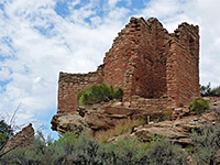
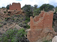
In a wild, remote and somewhat forgotten part of the Southwest, Hovenweep National Monument contains six separate prehistoric ruined villages dating from the Pueblo period of the mid thirteenth century. The monument spans the UT/CO border though the largest and best preserved site is in Utah - the land hereabouts is similar to Colorado's Mesa Verde National Park but on a smaller scale, with flat, bushy mesas split by steep-sided, quite narrow ravines, and the settlements typically consist of several small ruins on or just below the rim around the head of a canyon.
Although in some cases little remains beyond a pile of stones or low wall remnants, the interest and appeal is enhanced by the general remoteness and peaceful nature of the surroundings. The name Hovenweep, a Paiute word meaning deserted valley, was bestowed on this region by explorer and photographer William Jackson in 1874, and the site became a national monument in 1923.
Although in some cases little remains beyond a pile of stones or low wall remnants, the interest and appeal is enhanced by the general remoteness and peaceful nature of the surroundings. The name Hovenweep, a Paiute word meaning deserted valley, was bestowed on this region by explorer and photographer William Jackson in 1874, and the site became a national monument in 1923.
Hovenweep Table of Contents
- Map of the national monument
- Photographs
- Approach
- Square Tower Unit
- Other ruins at Hovenweep
- Colorado units: Cuthroat Castle, Horseshoe/Hackberry/Holly
- Nearby places
- Similar places
Location
Overview map of Canyons of the Ancients National Monument in Colorado, showing the units of Hovenweep.
Photographs
Square Tower and Cutthroat Castle, Horseshoe, Hackberry and Holly groups.
Approach
Hovenweep National Monument is reached from the south by several paved roads, starting from either US 191, Aneth on UT 262 or US 160 near Cortez in Colorado - this latter (Montezuma County Road G) is the longest, a bendy route through cultivated land along McElmo Creek and past some entrances to Colorado's Canyons of the Ancients National Monument. The drive from US 191 is the most used approach; it forks several times though all turnings are well signposted, and crosses rather desolate country, mostly flat, sandy and featureless apart from three distant mountain ranges to the northwest, east and south (Manti La Sal in Utah, Sleeping Ute in Colorado and Carrizo in Arizona). All these routes cross part of the Navajo Indian reservation, and there tends to be a lot of roadside litter.
Square Tower Unit
| Hovenweep - one of the 20 least visited national monuments in the West |
Other Ruins at Hovenweep
The other five ancient villages are much less visited as they are largely undeveloped and not well signposted, and four are reached only by unmaintained dirt roads. Only one is in Utah - the Cajon site on the Navajo Reservation, 9 miles southwest, near the upper end of Allen Canyon. The other four are in Colorado - isolated locations surrounded by anonymous BLM land that is now part of the large Canyons of the Ancients National Monument, established in 2001. The adjacent ruins of Horseshoe and Hackberry are the closest, requiring just a one mile drive on an unpaved road, and like the Little Ruin site have scattered buildings on rocky canyon rims in a similar mixed state of preservation. Many ruins are completely unexcavated and often consist of just an earthen mound with stones on top. Straying from the official path is not encouraged though some buildings cannot be seen otherwise. Holly is further down the approach road, while a little way east is the more remote Cutthroat Castle Group, which is different to the other settlements as most dwellings are built within a canyon, not on the rim, and also because it has a relatively large number of kivas - circular ceremonial houses not found elsewhere in Hovenweep. The final site is Goodman Canyon, in a different part of Canyons of the Ancients National Monument, reached by a paved road from Arriola.
Hovenweep - Other Sites
Cutthroat Castle Group
★★★★★
★★★★★
0.2 miles, 40 feet
Towers, rooms and kivas on the edge of a shallow canyon, reached by a rough track and a short trail, or via a longer hike from the main roadHorseshoe/Hackberry and Holly Groups
★★★★★
★★★★★
0.6 miles and 0.3 miles, 40 feet
Three ruin sites, in two detached units, with several round towers and square buildings; accessed by short pathsHovenweep - Nearby Places
- Mexican Hat (72 miles) - small settlement at the centre of some dramatic landscapes
- Montezuma Canyon (16 miles) - ruins and rock art along a 43 mile canyon
Hovenweep - Similar Places
- Mesa Verde National Park, Colorado - largest and most famous collection of ruins in the Southwest
- Walnut Canyon National Monument, Arizona - ancient ruins in a deep canyon near Flagstaff
All Contents © Copyright The American Southwest | Comments and Questions | Contribute | Affiliate Marketing Disclosure | Site Map


