Highlights:
15 mile road through the deepening canyon of the Colorado River west of Moab, passing a variety of interesting locations including arches, narrow canyons, petroglyphs and dinosaur footprints
Nearby town:
Moab, 4 miles
Management:
BLM
Location:
38.575, -109.633 (Gold Bar)
Seasons:
All year
Rating (1-5):
★★★★★
Weather:
Featured Hotel
Holiday Inn Express Moab
 Half a mile south of Arches National Park near the north end of Potash Road; a popular hotel with scenic surroundings. Free hot breakfast and an indoor pool
Check Rates
Two roads follow the Colorado River either side of Moab, both passing through spectacular red rock landscapes; the eastern route (Hwy 128) is a well traveled highway leading eventually to I-70, while the west route (Hwy 279, Potash Road, also known as the Potash-Lower Colorado River Scenic Byway) is much less busy, running alongside the Colorado through a deepening, sheer-walled Wingate sandstone canyon for 15 miles, as far as the active mining center of Potash.
From here the road becomes a 4WD track, crosses Shafer Basin and ascends into the Island in the Sky district of Canyonlands National Park through more scenic terrain, but the paved section has plenty to see, including sandstone arches, petroglyphs, dinosaur footprints, narrow side canyons, sheer cliffs popular for rock climbing, and the river itself, which flows right next to the road through a thin corridor of trees and bushes.
From here the road becomes a 4WD track, crosses Shafer Basin and ascends into the Island in the Sky district of Canyonlands National Park through more scenic terrain, but the paved section has plenty to see, including sandstone arches, petroglyphs, dinosaur footprints, narrow side canyons, sheer cliffs popular for rock climbing, and the river itself, which flows right next to the road through a thin corridor of trees and bushes.
Potash Road Table of Contents
- Map of Potash Road
- Photographs
- Introduction
- Petroglyphs
- Dinosaur tracks
- Arches, including the Corona Arch Trail
- Nearby places
- Similar places
Potash Road Map

Photographs
23 views along Potash Road.
Introduction
The BLM operate three campgrounds along the way, each pleasantly situated next to shady trees and bushes, within sight of the river, though the free primitive camping that used to be possible at other locations is no longer permitted. The canyon also contains a single track railway (built 1964), which parallels the last six miles of the road and is used to transport processed potash and salt from the mine. After leaving the river, it turns north up a narrow ravine (Bootlegger Canyon) and then through a 1.6 mile tunnel, emerging into Moab Valley opposite the entrance to Arches National Park, and following US 191 northwards to a junction with the main line at Crescent Junction. Only a few trains travel on the line each week, however, and the Colorado River canyon along the Potash Road is very quiet and peaceful, especially at night when camping.
Potash Road Petroglyphs
Potash Road forks south off US 191 a short distance from the Colorado River, 4 miles northwest of the center of Moab. At the junction is a large tailings pile from a former uranium ore processing plant, now gradually being removed and shipped to a disposal site near Crescent Junction. For 3 miles the road runs along the base of the 1,000 foot cliffs lining the west side of Moab Valley then turns southwest, along the Colorado River canyon, which is bordered by Poison Spider Mesa to the north and the convoluted plateau of Behind the Rocks to the south. In most places there is very little room between river, road and cliffs, but some locations have sandbanks, bushes and cottonwood groves, one of which is the location for the first of three BLM campgrounds (Jaycee Park, with 7 walk-in tent sites); soon after, the cliffs become especially sheer, a section known as Wall Street, where most of the technical rock climbing takes place. The next attraction, a short distance south, is an extended panel of Fremont Indian petroglyphs, quite high above the road (15 feet or so), hence in good condition, not spoiled by modern graffiti. The drawings have a good variety of forms and styles, depicting human figures, animals, hunting scenes and abstract shapes, carved on rock that is either natural orange-brown in color, or stained black by desert varnish. Williams Bottom Campground is situated near the petroglyphs, like Jaycee Point set amongst shady cottonwood trees; both loose the sun relatively early in the afternoon, owing to the orientation of the cliffs.
Potash Road Dinosaur Tracks
The next point of interest is some fossilized dinosaur tracks, on a broken block of sandstone a little way above the road, reachable by a short scramble up the hillside. The adjacent parking area is also used for the Poison Spider Trail, a 9 mile hike/mountain bike path that ascends to the top of the cliffs and loops around the top of the mesa, returning (via the Portal Trail) to the road near Jaycee Point. At the trailhead, the river starts a big bend back to the north, the cliffs become less steep and several side canyons join - one (Bootlegger) provides a course for the Potash railway, and for the 1.5 mile trail to Bowtie Arch and Corona Arch, two of the highlights of this area.
Potash Road Arches
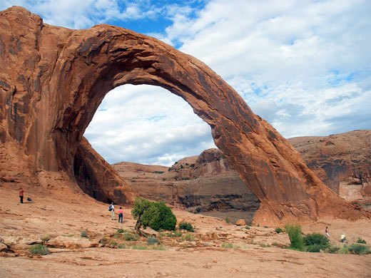
Parking for the Corona Arch Trail is just across from the Gold Bar campground/day use area, unlike the other two camps located between road and river, and benefiting from fine views up and down the canyon. It also has rather more space, and is suitable even for the largest RVs. The trail heads west, up the railway embankment and across the tracks just as the line enters a deep cutting through the Wingate sandstone cliffs. On the far side, the path rounds the edge of the escarpment and ascends a steepish slope to a sandy plateau, beneath higher cliffs to the north, containing a third arch (Pinto), though the opening is hidden so the feature is not recognizable as an arch from this viewpoint. It could however be seen by walking off trail cross slickrock for about a quarter of a mile. The trail descends a little and curves round a promontory close to Bootlegger Canyon, within sight of the railway, now running some distance lower down. Two sets of railings and a short ladder aid hikers past a few steep sections, as the path crosses a wide slickrock basin beneath the two arches, both composed of Navajo sandstone. Bowtie Arch has a narrow, circular opening - a former pothole - above a streaked sandstone bowl, while Corona Arch is much more dramatic - a graceful, free standing curve 140 feet across and 100 feet above the ground, projecting outwards from the cliffs. It resembles the famous Rainbow Bridge beside Lake Powell, hence its original name of Little Rainbow Bridge, though the structure is properly an arch (formed by wind/weather erosion) rather than a bridge (carved by flowing water). The arch can be viewed from either side, though a sheer drop off to another colorful sandstone basin to the west prevents walking any further along Bootlegger Canyon at this level. Back on Potash Road, the only other notable feature during the final 5 miles to the end of the paved route is Jug Handle Arch, at the junction of Long Canyon with the Colorado River. A rough track, for 4WD vehicles only, follows Long Canyon upstream (westwards) past many shapely red rock formations then climbs steeply up to Dead Horse Point, the highest section being known informally as Pucker Pass.
Potash Road - Nearby Places
- Arches National Park (1 mile) - world famous arches and other eroded formations
- Dead Horse Point State Park (25 miles) - high promontory overlooking Colorado River canyons
- Professor Creek - narrow canyon with a permanent stream, 20 miles northeast of Moab
Potash Road - Similar Places
- Nebo Loop Scenic Byway - varied scenery along a narrow road through the Wasatch Mountains
All Contents © Copyright The American Southwest | Comments and Questions | Contribute | Affiliate Marketing Disclosure | Site Map


