Orderville Canyon
Spectacular, long and very deep gorge joining the Zion Narrows. The lower 3 miles are most impressive, and part contains a permanent stream, with pools, waterfalls and several huge chokestones
Length: 2.9 miles to the start of the canyon, 5.1 miles to the park boundary, 8.4 miles to Zion Canyon, 11 miles to the end of the scenic drive
Difficulty: Moderate - pools and chokestones towards the lower end
Management: Most is within Zion National Park. The upper stretches are on BLM or private land
Rocks: Navajo sandstone
Season: Summer, fall
Trailhead: Short distance down a track branching west off Chamberlain Ranch Road, 11.3 miles from UT 9
Rating (1-5): ★★★★★

Together with Deep Creek and Kolob Creek, Orderville Canyon is one of the major tributaries of the Virgin River Narrows and has equally spectacular scenery. It is as deep, over 1,000 feet in places, but even narrower and is easier to explore in some ways as most of the canyon is dry, although a stream does flow for the last couple of miles and has a few large pools and chokestones.
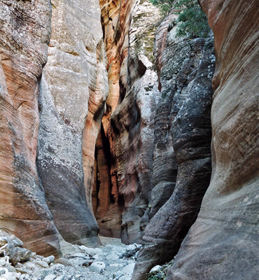
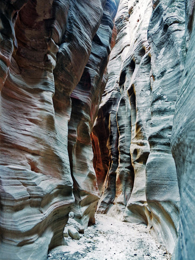
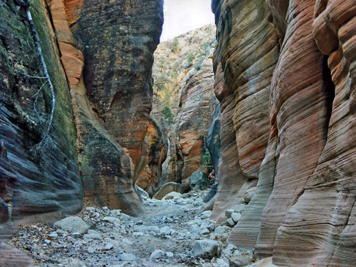
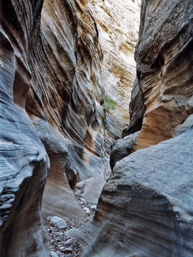
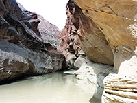
All of Orderville Canyon is impressive, especially the lowest three miles which have long, exquisitely-textured passageways with striated rocks in various shades of red and grey, quite like the best parts of Buckskin Gulch but deeper and with more colour variation. The hike is popular although much less travelled than the main narrows so has the added advantage of increased solitude, and also passes several interesting side canyons worth exploring.
Topographic map of Orderville Canyon.
Exploration of Orderville Canyon is possible from either end - the junction with the main narrows is just 1.5 miles from the Zion Canyon scenic drive, and the upper part is reached by a good quality gravel track that branches off UT 9, east of the national park boundary. One way hikes are possible if a car shuttle can be arranged, and these are normally done from east to west as the obstructions in the lower section are easier descended than ascended. So, directions here are to the upper trailhead - the approach is by the signposted road to North Fork (Chamberlain Ranch Road) that leaves UT 9 at milepost 46. This is paved for a while then graded gravel after the Zion Ponderosa Lodge, an excessively-advertised business that seems to own all the surrounding land for some distance and posts countless No Trespassing and No Hunting notices. The route is along a hillside and around the tops of several tributary ravines including Birch Hollow and Englestead Hollow, through bushy land which drops off quite steeply to the west and affords views of the great white cliffs of Zion Canyon in the distance.
After 12 miles a narrow side road branches left, next to a BLM sign announcing various back-country use regulations that apply to the Orderville Gulch region. The usual parking and/or camping area for the hike is at a corral 1/3 mile down the side track, though larger vehicles may have to be left at the main road while 4WD cars can continue - past the corral the track becomes very rough as it descends a wooded, rocky hillside into the upper end of Orderville Canyon. A small stream usually flows at this point but soon sinks below ground. The track follows the north side for half a mile, crosses over and briefly enters private land (also owned by Zion Ponderosa Lodge), passes a small reservoir then parallels the south side, through a grassy meadow and beneath cliffs that begin to steepen and show colorful strata, for 2/3 mile more to where the streambed starts to cut downwards. This is about a one hour walk from the main road.
A permit is needed for day trips into the canyon, currently (2024) 1-2 people: $15, 3-7 people: $20, 8-12 people: $25, and the lower half is subject to Zion National Park regulations, so technically an additional $35 entrance fee is due.
17 views of Orderville Canyon.
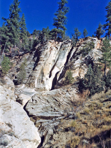
At first the route is either down the streambed or along paths that cut across meanders. After a 10 minute walk the canyon proper begins - a drop of 30 meters at the confluence with another ravine that joins from the south marks the point when the walls close in and become vertical. This dryfall is easily bypassed by a steep path on the left side, then from here the hike simply involves walking down the stony canyon floor for nearly 6 miles to the Virgin River.
After the dryfall the canyon has towering cliffs of Navajo sandstone and is soon about 300 feet deep, still relatively wide with sandbanks at either side, many fir trees and bushes, and occasional huge boulders fallen from the rocks above. Some of its side canyons are more slot-like, such as Walker Gulch which joins from the right after another mile.
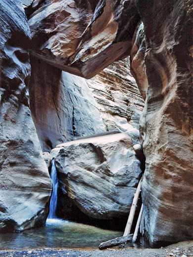
Walking is easy along the level floor and the straight, sunny passageways, although recent rainfall may create extensive patches of clayish mud and a few pools, but there are no major obstructions until shortly before the national park boundary, around the point where the streambed begins to cover all of the canyon floor and the passages narrow noticeably. Here, a chokestone has created a 15 foot drop which can quite easily be downclimbed using an old log that has been wedged underneath for many years, although some may need a rope - if so there is a webbing attachment securely bolted to the rocks on the right hand side.
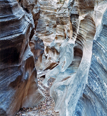
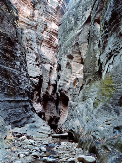
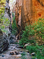
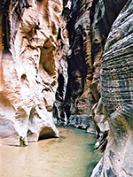
The NPS boundary is marked by a rusty sign as the good narrow section continues; now trees and bushes are found only occasionally and the canyon varies between 3 and 5 meters wide while above the water-carved, thin-layered, greyish cliffs are over 600 feet high. Red rocks appear around stream level and start to predominate as the canyon deepens, making the surroundings even more colorful and pretty. The gorge becomes somewhat wider for a while then the best and longest stretch of narrows begins and extends all the way to the Virgin River confluence. A stream starts to flow near the junction with Bullock Gulch, a side canyon on the north side.
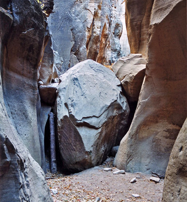
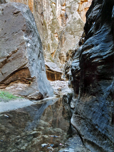
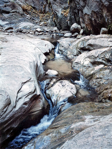
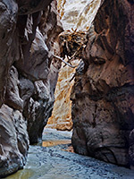
Obstructions become more frequent as the stream flow increases - first is a 10 foot log jam, presumably temporary, which is simple to climb over using protruding tree stumps, then next is another 15 foot drop over a boulder into a pool several feet deep. Again there is a webbing attachment and several logs that can be used to aid the descent for those without ropes. A few meters directly above is another huge boulder of similar size, wedged between the canyon walls. By now the creek has clear, fast-flowing water and has many nice pools, cascades and small waterfalls. Two narrow, overgrown side canyons join in quick succession from the north, opposite 2 more on the south side, then no more until the main junction. Walking is now through water much of the time, but usually this is no more than 2 feet deep.
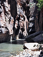
About half a mile from the river is the third main problem - another large chokestone that has created a 4 foot waterfall above a pool of similar depth, and here there is no alternative but to jump into the water and wade across. The final stretch has a few other deepish pools with lesser drops and becomes quite level before meeting the river, where the water is colder, deeper and flows faster. It also tends to have more hikers, exploring some of the lower end after walking up the Zion Narrows.
All of Orderville Canyon is impressive, especially the lowest three miles which have long, exquisitely-textured passageways with striated rocks in various shades of red and grey, quite like the best parts of Buckskin Gulch but deeper and with more colour variation. The hike is popular although much less travelled than the main narrows so has the added advantage of increased solitude, and also passes several interesting side canyons worth exploring.
Orderville Map
Topographic map of Orderville Canyon.
Location
Exploration of Orderville Canyon is possible from either end - the junction with the main narrows is just 1.5 miles from the Zion Canyon scenic drive, and the upper part is reached by a good quality gravel track that branches off UT 9, east of the national park boundary. One way hikes are possible if a car shuttle can be arranged, and these are normally done from east to west as the obstructions in the lower section are easier descended than ascended. So, directions here are to the upper trailhead - the approach is by the signposted road to North Fork (Chamberlain Ranch Road) that leaves UT 9 at milepost 46. This is paved for a while then graded gravel after the Zion Ponderosa Lodge, an excessively-advertised business that seems to own all the surrounding land for some distance and posts countless No Trespassing and No Hunting notices. The route is along a hillside and around the tops of several tributary ravines including Birch Hollow and Englestead Hollow, through bushy land which drops off quite steeply to the west and affords views of the great white cliffs of Zion Canyon in the distance.

Orderville Canyon Trailhead
After 12 miles a narrow side road branches left, next to a BLM sign announcing various back-country use regulations that apply to the Orderville Gulch region. The usual parking and/or camping area for the hike is at a corral 1/3 mile down the side track, though larger vehicles may have to be left at the main road while 4WD cars can continue - past the corral the track becomes very rough as it descends a wooded, rocky hillside into the upper end of Orderville Canyon. A small stream usually flows at this point but soon sinks below ground. The track follows the north side for half a mile, crosses over and briefly enters private land (also owned by Zion Ponderosa Lodge), passes a small reservoir then parallels the south side, through a grassy meadow and beneath cliffs that begin to steepen and show colorful strata, for 2/3 mile more to where the streambed starts to cut downwards. This is about a one hour walk from the main road.
Permit
A permit is needed for day trips into the canyon, currently (2024) 1-2 people: $15, 3-7 people: $20, 8-12 people: $25, and the lower half is subject to Zion National Park regulations, so technically an additional $35 entrance fee is due.
Photographs
17 views of Orderville Canyon.
Orderville Canyon Route Description
At first the route is either down the streambed or along paths that cut across meanders. After a 10 minute walk the canyon proper begins - a drop of 30 meters at the confluence with another ravine that joins from the south marks the point when the walls close in and become vertical. This dryfall is easily bypassed by a steep path on the left side, then from here the hike simply involves walking down the stony canyon floor for nearly 6 miles to the Virgin River.
After the dryfall the canyon has towering cliffs of Navajo sandstone and is soon about 300 feet deep, still relatively wide with sandbanks at either side, many fir trees and bushes, and occasional huge boulders fallen from the rocks above. Some of its side canyons are more slot-like, such as Walker Gulch which joins from the right after another mile.
The Upper Canyon
Walking is easy along the level floor and the straight, sunny passageways, although recent rainfall may create extensive patches of clayish mud and a few pools, but there are no major obstructions until shortly before the national park boundary, around the point where the streambed begins to cover all of the canyon floor and the passages narrow noticeably. Here, a chokestone has created a 15 foot drop which can quite easily be downclimbed using an old log that has been wedged underneath for many years, although some may need a rope - if so there is a webbing attachment securely bolted to the rocks on the right hand side.
National Park Boundary
The NPS boundary is marked by a rusty sign as the good narrow section continues; now trees and bushes are found only occasionally and the canyon varies between 3 and 5 meters wide while above the water-carved, thin-layered, greyish cliffs are over 600 feet high. Red rocks appear around stream level and start to predominate as the canyon deepens, making the surroundings even more colorful and pretty. The gorge becomes somewhat wider for a while then the best and longest stretch of narrows begins and extends all the way to the Virgin River confluence. A stream starts to flow near the junction with Bullock Gulch, a side canyon on the north side.
Obstructions
Obstructions become more frequent as the stream flow increases - first is a 10 foot log jam, presumably temporary, which is simple to climb over using protruding tree stumps, then next is another 15 foot drop over a boulder into a pool several feet deep. Again there is a webbing attachment and several logs that can be used to aid the descent for those without ropes. A few meters directly above is another huge boulder of similar size, wedged between the canyon walls. By now the creek has clear, fast-flowing water and has many nice pools, cascades and small waterfalls. Two narrow, overgrown side canyons join in quick succession from the north, opposite 2 more on the south side, then no more until the main junction. Walking is now through water much of the time, but usually this is no more than 2 feet deep.
Virgin River Confluence
About half a mile from the river is the third main problem - another large chokestone that has created a 4 foot waterfall above a pool of similar depth, and here there is no alternative but to jump into the water and wade across. The final stretch has a few other deepish pools with lesser drops and becomes quite level before meeting the river, where the water is colder, deeper and flows faster. It also tends to have more hikers, exploring some of the lower end after walking up the Zion Narrows.
Orderville is one of the top 25 slot canyons
Orderville Canyon - Similar Hikes
All Contents © Copyright The American Southwest | Comments and Questions | Contribute | Affiliate Marketing Disclosure | Site Map