Red Hollow and Spring Hollow
Two short narrow canyons cutting into the Glendale Bench, east of Zion NP. Spring Hollow (currently not accessible) contains a stream, soon reaching a scenic but unclimbable waterfall, while the longer Red Hollow forms deeper passages, again explorable in full only from the top, with ropes
Length: 0.6 miles (Red Hollow)
Difficulty: Easy, to the obstructions
Management: BLM
Rocks: Navajo sandstone
Season: Spring, summer, fall
Trailhead: (Red Hollow) - end of a short track heading east from Orderville
Rating (1-5): ★★★★★
Difficulty: Easy, to the obstructions
Management: BLM
Rocks: Navajo sandstone
Season: Spring, summer, fall
Trailhead: (Red Hollow) - end of a short track heading east from Orderville
Rating (1-5): ★★★★★

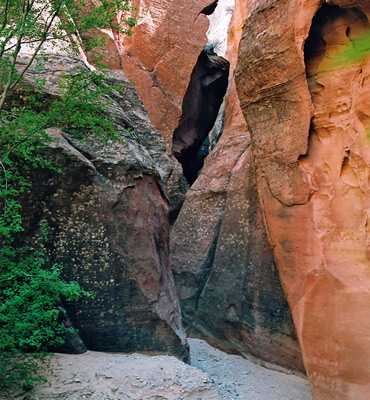
The Elkheart Cliffs, a few miles east of Zion National Park, harbor several narrow canyons - Sand Wash/Red Cave is the largest but two other good short slots are found nearby. Red Hollow, east of Orderville and easily reached from US 89, has narrow, vertical-walled passages through deep red rocks, most of which is hikeable from the lower end though an unclimbable dryfall means that the full length can only be explored from above, using ropes.
Three miles north, just south of Glendale, Spring Hollow contains a shorter narrows section, usually with a shallow stream flowing through, that ends in an enclosed chamber beneath a pretty waterfall. Access to this is no longer possible, however, since the previously-used approach, from the lower end, crosses private land.
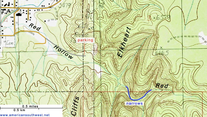
Red Hollow is the main drainage emerging from the Elkheart Cliffs due east of Orderville, a small town on US 89 five miles north of the junction with UT 9 from Zion. A half mile dirt track leads towards the cliffs and the mouth of the canyon, starting at 100 E St in town; south one block then left (along Red Hollow Drive), a road that soon becomes unpaved then a bit rough and sandy, including one crossing of a streambed, so 4WD may be needed. The track ends by a fence in front of a water tank, from where the wash is a short walk downhill.
7 views of Red Hollow and Spring Hollow.
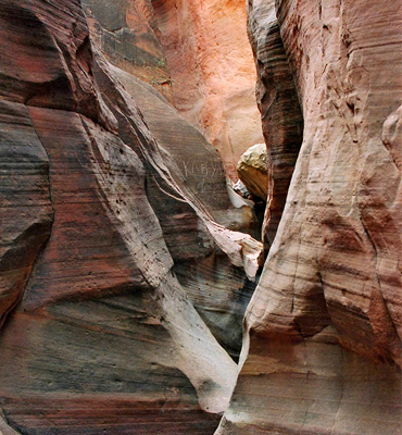
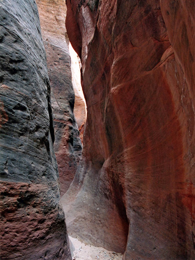
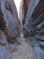
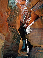
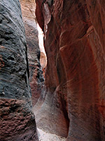
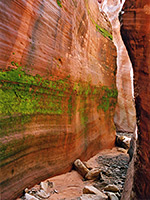
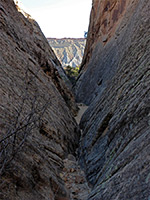
The stony wash splits after a short distance upstream, at the base of the Elkheart Cliffs. The right branch enters a V-shaped, white-walled ravine that gains height steadily and is not narrow, while the left fork forms a more enclosed red rock gorge that becomes a slot after 1/4 mile. This canyon is deep from the start and soon is just a few feet across and sheer walled, without any overhanging rocks so the passageways are well lit, but not particularly distinctive as the rock is uniform in texture and grey/dark red in color - no delicate curves or decorative strata. The slot curves gently while remaining generally straight and has a few chokestones up of to 6 feet, though nothing too difficult until a higher fall of 25 feet on top of which are several webbing attachments for those descending from above.
Graffiti carved on some parts of the walls and abundant footprints suggest the canyon is often visited. The lower narrows, up to the dryfall, can all be seen in half an hour and while not especially pretty, Red Hollow makes for an enjoyable quarter day hike. Although the canyon is dry much of the year, at some times a fair amount of water might be present, making conditions rather more difficult.
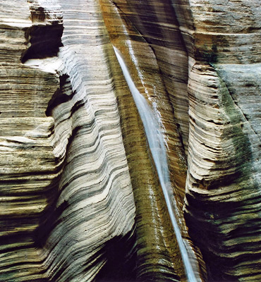
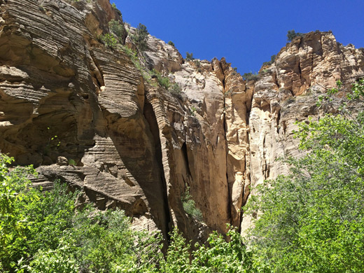
The Spring Hollow creek emerges from quite a narrow opening at the side of the low cliffs that line this part of the Virgin River valley, above which is a straight passage through white/light brown rocks. After two bends and a quarter of a mile of canyon, the creek enters a shady chamber where the water falls 20 feet into a shallow pool, cascading down a wall of horizontal, thin-layered strata; a photogenic scene. Away from the waterfall, the rocks are carved with hundreds of inscriptions, mostly quite recent but some dating from the late nineteenth century, such as from several members of the Kent family.
Three miles north, just south of Glendale, Spring Hollow contains a shorter narrows section, usually with a shallow stream flowing through, that ends in an enclosed chamber beneath a pretty waterfall. Access to this is no longer possible, however, since the previously-used approach, from the lower end, crosses private land.
Topographic Map of Red Hollow
Location
Red Hollow is the main drainage emerging from the Elkheart Cliffs due east of Orderville, a small town on US 89 five miles north of the junction with UT 9 from Zion. A half mile dirt track leads towards the cliffs and the mouth of the canyon, starting at 100 E St in town; south one block then left (along Red Hollow Drive), a road that soon becomes unpaved then a bit rough and sandy, including one crossing of a streambed, so 4WD may be needed. The track ends by a fence in front of a water tank, from where the wash is a short walk downhill.
Photographs
7 views of Red Hollow and Spring Hollow.
Route Description
Red Hollow
The stony wash splits after a short distance upstream, at the base of the Elkheart Cliffs. The right branch enters a V-shaped, white-walled ravine that gains height steadily and is not narrow, while the left fork forms a more enclosed red rock gorge that becomes a slot after 1/4 mile. This canyon is deep from the start and soon is just a few feet across and sheer walled, without any overhanging rocks so the passageways are well lit, but not particularly distinctive as the rock is uniform in texture and grey/dark red in color - no delicate curves or decorative strata. The slot curves gently while remaining generally straight and has a few chokestones up of to 6 feet, though nothing too difficult until a higher fall of 25 feet on top of which are several webbing attachments for those descending from above.
Graffiti carved on some parts of the walls and abundant footprints suggest the canyon is often visited. The lower narrows, up to the dryfall, can all be seen in half an hour and while not especially pretty, Red Hollow makes for an enjoyable quarter day hike. Although the canyon is dry much of the year, at some times a fair amount of water might be present, making conditions rather more difficult.
Spring Hollow
The Spring Hollow creek emerges from quite a narrow opening at the side of the low cliffs that line this part of the Virgin River valley, above which is a straight passage through white/light brown rocks. After two bends and a quarter of a mile of canyon, the creek enters a shady chamber where the water falls 20 feet into a shallow pool, cascading down a wall of horizontal, thin-layered strata; a photogenic scene. Away from the waterfall, the rocks are carved with hundreds of inscriptions, mostly quite recent but some dating from the late nineteenth century, such as from several members of the Kent family.
Red Hollow - Similar Hikes
All Contents © Copyright The American Southwest | Comments and Questions | Contribute | Affiliate Marketing Disclosure | Site Map