Lower Gaylor Lake Trail, Yosemite National Park
California > Yosemite National Park > Tuolumne Meadows > Hiking > Lower Gaylor Lake

Lower Gaylor Lake Trail
Lesser used route up a wooded hillside and across short grass meadows above the treeline, ending at the south edge of a shallow Alpine lake, elevation 10,060 feet
Length: 2.5 miles
Elevation change: 800 feet
Difficulty: Easy
Type: One way. The Upper Gaylor Lakes can be reached by a short cross-county hike
Usage: Low
Season: Summer and fall
Trailhead: Narrow verge beside the Tioga Road
Rating (1-5): ★★★★★
Elevation change: 800 feet
Difficulty: Easy
Type: One way. The Upper Gaylor Lakes can be reached by a short cross-county hike
Usage: Low
Season: Summer and fall
Trailhead: Narrow verge beside the Tioga Road
Rating (1-5): ★★★★★

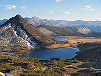
The Middle and Upper of the three Gaylor Lakes may be visited on a short but initially steep trail beginning right next to the eastern Yosemite National Park entrance station at Tioga Pass. A lesser used path forks off towards the lower lake, one mile away across a flat, open plateau, though the usual approach is via a different trail that starts further west along the park road and climbs gently through pine woods for 2 miles, into the meadowland bordering the lake.
The attraction of this region of the park is the sparkling Alpine scenery, largely free of trees to block the views, which extend many miles in most directions, over smooth slopes and jagged granite summits. Because of the high elevations (above 10,000 feet), only short grass, small flowers and stunted bushes grow in most places, incompletely covering the bedrock so that the ground is sprinkled with white granite boulders, adding to the prettiness of the landscape.
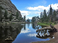
The official start point for the Lower Gaylor Lake Trail is at Tuolumne Lodge, in the forest just east of Tuolumne Meadows, from where the path runs close to the Dana Fork river for 1.5 miles then turns north, crossing the Tioga Road; a shorter option, therefore, is to park beside the highway, though the route is not signposted at this point, and is difficult to locate. There is room for a couple of vehicles at the crossing, and a few more a little way west, but generally the roadside verges hereabouts are too narrow for parking. The only indication of the path is an old, rusty trailhead notice, set back slightly from the road.
Lower Gaylor Lake topographic map, Tuolumne Meadows trails.
The Lower Gaylor Lake Trail enters the forest and climbs gradually, past a track to an old borrow pit on the left then along the edge of a large meadow to a junction beside the lake's outlet stream, from where a barely used path forks east, towards the trailhead for Mono Pass. The main trail continues ascending through moist, shady woodland, carpeted by tall grass, lilies and other wildflowers, staying quite close to the creek. The gradient steepens somewhat for a while as granite boulders appear and the trees are more spread out, allowing more sun to reach the forest floor; after here the route moves away from the stream, through a temporarily thicker section of woodland before the land flattens out, and the pines give way to open, grassy slopes above the treeline. The ground is sparsely covered by grass, moss, lichen and tiny flowers, reflecting the limited nutrients and short summer growing season.
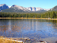
The trail is now straight and narrow, worn down several inches into the soft earth of the meadow. The most visible wildlife are mice, who find an ideal home amongst the tufty grass and easily-burrowed soils; other creatures that may be seen are pikas, marmots and hares. Surrounding the grassland are gentle slopes of grey-white granite to the west and east, and higher, reddish hills to the north, at the edge of the metamorphosed region along the eastern Sierra crest. Several shallow, boulder-studded ponds are passed on the right, before the path arrives at the edge of Lower Gaylor Lake; a fainter trail (no stock allowed) runs northeastwards, through a belt of dwarf pine trees towards the middle lake. The lower lake is very pretty, with a backdrop of granite cliffs to the north, tundra grass on the other sides, and a band of protruding rocks across one section, making it possible to walk out towards the middle.
The attraction of this region of the park is the sparkling Alpine scenery, largely free of trees to block the views, which extend many miles in most directions, over smooth slopes and jagged granite summits. Because of the high elevations (above 10,000 feet), only short grass, small flowers and stunted bushes grow in most places, incompletely covering the bedrock so that the ground is sprinkled with white granite boulders, adding to the prettiness of the landscape.
Lower Gaylor Lake Trailhead
The official start point for the Lower Gaylor Lake Trail is at Tuolumne Lodge, in the forest just east of Tuolumne Meadows, from where the path runs close to the Dana Fork river for 1.5 miles then turns north, crossing the Tioga Road; a shorter option, therefore, is to park beside the highway, though the route is not signposted at this point, and is difficult to locate. There is room for a couple of vehicles at the crossing, and a few more a little way west, but generally the roadside verges hereabouts are too narrow for parking. The only indication of the path is an old, rusty trailhead notice, set back slightly from the road.
Maps
Lower Gaylor Lake topographic map, Tuolumne Meadows trails.

The Path
The Lower Gaylor Lake Trail enters the forest and climbs gradually, past a track to an old borrow pit on the left then along the edge of a large meadow to a junction beside the lake's outlet stream, from where a barely used path forks east, towards the trailhead for Mono Pass. The main trail continues ascending through moist, shady woodland, carpeted by tall grass, lilies and other wildflowers, staying quite close to the creek. The gradient steepens somewhat for a while as granite boulders appear and the trees are more spread out, allowing more sun to reach the forest floor; after here the route moves away from the stream, through a temporarily thicker section of woodland before the land flattens out, and the pines give way to open, grassy slopes above the treeline. The ground is sparsely covered by grass, moss, lichen and tiny flowers, reflecting the limited nutrients and short summer growing season.

Lower Gaylor Lake
The trail is now straight and narrow, worn down several inches into the soft earth of the meadow. The most visible wildlife are mice, who find an ideal home amongst the tufty grass and easily-burrowed soils; other creatures that may be seen are pikas, marmots and hares. Surrounding the grassland are gentle slopes of grey-white granite to the west and east, and higher, reddish hills to the north, at the edge of the metamorphosed region along the eastern Sierra crest. Several shallow, boulder-studded ponds are passed on the right, before the path arrives at the edge of Lower Gaylor Lake; a fainter trail (no stock allowed) runs northeastwards, through a belt of dwarf pine trees towards the middle lake. The lower lake is very pretty, with a backdrop of granite cliffs to the north, tundra grass on the other sides, and a band of protruding rocks across one section, making it possible to walk out towards the middle.

Lower Gaylor Lake Trail - Similar Hikes

All Contents © Copyright The American Southwest | Comments and Questions | Contribute | Affiliate Marketing Disclosure | Site Map