Gooseberry Trail and Monument Basin, Canyonlands National Park
Utah > Canyonlands National Park > Island in the Sky > Hiking > Gooseberry Trail and Monument Basin

Gooseberry Trail and Monument Basin
Relatively short but initially very steep path, descending from the plateau near Grand View Point then following a shallow, rocky wash to the White Rim Road, at the brink of Gooseberry Canyon. A 1.3 mile continuation hike, mostly off-trail, reaches the rim of Monument Basin, for spectacular views of its red rock buttes and spires
Length: 2.7 miles to the White Rim Road, 4 miles to Monument Basin (or 6.7 miles if following the road)
Elevation change: 1,480 feet
Difficulty: Strenuous
Type: One way, partly off trail (to the basin). Continuation hikes possible along the White Rim Road
Usage: Low
Season: All year, though summers are very hot
Trailhead: Near the south end of the scenic drive, along a short picnic loop road
Rating (1-5): ★★★★★

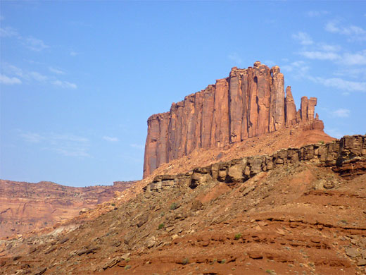
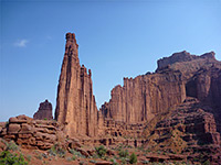
Of the five maintained paths that descend from Island in the Sky to the White Rim Road, the Gooseberry Trail (originally known as the Government Trail) is the shortest, partly as the trailhead lies very close to the edge of the plateau, but it is also the steepest, descending 1,100 feet in little more than one mile. The remaining 1.5 miles is much gentler, following a shallow dry wash and meeting the White Rim Road at the edge of Gooseberry Canyon, where the land falls away vertically another 200 feet. The trail is not often hiked, especially in summer, due to its steepness and exposure, though the trailhead is relatively busy, shared with the easy, nearly level route to White Rim Overlook, and also site of one of two picnic areas on the plateau.
Attractions of the hike are the quick descent to the White Rim, the views en route, and the chance to look over the rim into canyons lower down, from locations otherwise reachable only with a 4WD vehicle along the White Rim Road, a slow journey of 30 miles.
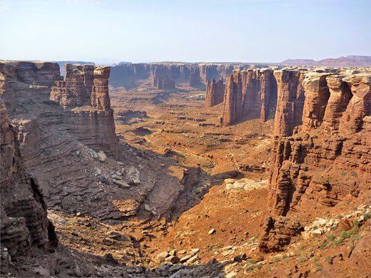
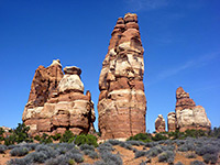
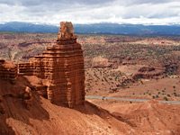
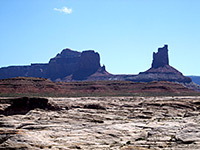
The trip is rewarding enough, but can be extended by heading south, either along the road or via a shortcut over a narrow ridge, to the rim of Monument Basin, a spectacular canyon system somewhat reminiscent of Monument Valley, containing many spires of red sandstone, some topped with more resistant white rock. The basin is seen from high above from the White Rim and Grand View overlooks, but is much more impressive close up, viewed from short walks in either direction along the rim.
Overview map of the Island in the Sky; topographic map of the Gooseberry Trail.
19 views along the Gooseberry Trail.
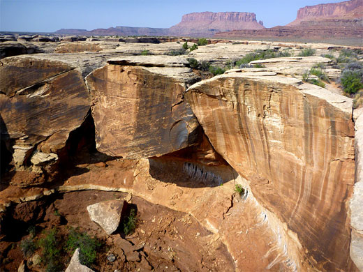
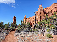
From the limited parking area at the trailhead, the path to White Rim Overlook heads east for about 300 feet, where the Gooseberry Trail forks off northwards and reaches the edge of the plateau in another 300 feet, then begins its very steep but well cairned descent - one of the steepest trails in any national park. The first section is down the side of a sloping bowl through the Kayenta Formation and the upper part of the underlying Wingate sandstone, winding through several long and short switchbacks, followed by a series of steps taking the path down the remainder of the Wingate layer. This constitutes about one third of the main part of this descent; the middle third is longer but a little less steep in places, down via more steps and switchbacks through the subunits of the Chinle Formation and to a narrow bench of the more resistant Moenkopi shale, which forms a flat-topped mesa to the north, on the far side of the valley below. The final third is steep once more, down to the upper end of a dry, rocky drainage, lined by low, thin-layered red cliffs.
The drainage is followed downstream for 1.5 miles to the White Rim Road; the drainage has a few downward drops, often where small tributaries join, the but most is fairly flat, and stony, so walking is now quite easy. The wash descends another 350 feet and towards the end the streamway becomes wide, crossing sandy flats and meeting the White Rim Road just 100 feet above a big drop off into the upper end of Gooseberry Canyon. This marks the end of the Gooseberry Trail, for most of which the Island in the Sky plateau seems still to be rather close, but now looks significantly more distant, though the trail is relatively short compared to others that descend to the White Rim like Wilhite or Lathrop.
A two-site primitive camping area is located a few hundred feet south of the end of the Gooseberry Trail, one of ten along the White Rim Road, for all of which advance reservations are recommended. From here, the edge of Monument Basin to the south is 4 miles away by road or 1.3 miles cross country, starting by walking along the road a little way then veering off southwards, past the edge of a promontory whilst aiming for the lowest point in the ridge extending east from White Rim Overlook, approaching along a wash bed. The climb to the saddle is relatively easy, up three steep sections separated by two benches, to a flat area where the basin first comes in to view directly ahead. The descent is similar, perhaps a little steeper and requiring route-finding to identify a way down the steepest section of the cliffs, but still not too difficult. The final part of the descent is down a big slope strewn with fallen folders, somewhat higher than the equivalent slope on the north side of the bench.
The White Rim Road winds along the base of this part of the hillside, just a few dozen feet from the north edge of Monument Basin, which can be viewed by walking southwest or southeast along the rim, where the land falls away vertically by up to 300 feet. Many of the pillars in the basin are composed solely of brown-red shale of the Organ Rock Formation, having lost their protective White Rim caprock, but those closest to the edge still have this covering, which tends to be wider than the column beneath. There are no hiking routes down to the valley floor, but walking a relatively short distance either way along the rim reveals a succession of changing perspectives, viewing the same formations from different angles. Monument Basin could in theory be reached by a much shorter hike (1.5 miles) via an unmarked route that descends from the plateau starting about half way along the Grand View Trail, but this is difficult to locate and quite dangerous, encountering several sheer drop-offs.
Attractions of the hike are the quick descent to the White Rim, the views en route, and the chance to look over the rim into canyons lower down, from locations otherwise reachable only with a 4WD vehicle along the White Rim Road, a slow journey of 30 miles.
The trip is rewarding enough, but can be extended by heading south, either along the road or via a shortcut over a narrow ridge, to the rim of Monument Basin, a spectacular canyon system somewhat reminiscent of Monument Valley, containing many spires of red sandstone, some topped with more resistant white rock. The basin is seen from high above from the White Rim and Grand View overlooks, but is much more impressive close up, viewed from short walks in either direction along the rim.

Maps
Overview map of the Island in the Sky; topographic map of the Gooseberry Trail.
Photographs
19 views along the Gooseberry Trail.

Gooseberry Trail
From the limited parking area at the trailhead, the path to White Rim Overlook heads east for about 300 feet, where the Gooseberry Trail forks off northwards and reaches the edge of the plateau in another 300 feet, then begins its very steep but well cairned descent - one of the steepest trails in any national park. The first section is down the side of a sloping bowl through the Kayenta Formation and the upper part of the underlying Wingate sandstone, winding through several long and short switchbacks, followed by a series of steps taking the path down the remainder of the Wingate layer. This constitutes about one third of the main part of this descent; the middle third is longer but a little less steep in places, down via more steps and switchbacks through the subunits of the Chinle Formation and to a narrow bench of the more resistant Moenkopi shale, which forms a flat-topped mesa to the north, on the far side of the valley below. The final third is steep once more, down to the upper end of a dry, rocky drainage, lined by low, thin-layered red cliffs.

Gooseberry Canyon
The drainage is followed downstream for 1.5 miles to the White Rim Road; the drainage has a few downward drops, often where small tributaries join, the but most is fairly flat, and stony, so walking is now quite easy. The wash descends another 350 feet and towards the end the streamway becomes wide, crossing sandy flats and meeting the White Rim Road just 100 feet above a big drop off into the upper end of Gooseberry Canyon. This marks the end of the Gooseberry Trail, for most of which the Island in the Sky plateau seems still to be rather close, but now looks significantly more distant, though the trail is relatively short compared to others that descend to the White Rim like Wilhite or Lathrop.

Route to Monument Basin
A two-site primitive camping area is located a few hundred feet south of the end of the Gooseberry Trail, one of ten along the White Rim Road, for all of which advance reservations are recommended. From here, the edge of Monument Basin to the south is 4 miles away by road or 1.3 miles cross country, starting by walking along the road a little way then veering off southwards, past the edge of a promontory whilst aiming for the lowest point in the ridge extending east from White Rim Overlook, approaching along a wash bed. The climb to the saddle is relatively easy, up three steep sections separated by two benches, to a flat area where the basin first comes in to view directly ahead. The descent is similar, perhaps a little steeper and requiring route-finding to identify a way down the steepest section of the cliffs, but still not too difficult. The final part of the descent is down a big slope strewn with fallen folders, somewhat higher than the equivalent slope on the north side of the bench.
The Basin
The White Rim Road winds along the base of this part of the hillside, just a few dozen feet from the north edge of Monument Basin, which can be viewed by walking southwest or southeast along the rim, where the land falls away vertically by up to 300 feet. Many of the pillars in the basin are composed solely of brown-red shale of the Organ Rock Formation, having lost their protective White Rim caprock, but those closest to the edge still have this covering, which tends to be wider than the column beneath. There are no hiking routes down to the valley floor, but walking a relatively short distance either way along the rim reveals a succession of changing perspectives, viewing the same formations from different angles. Monument Basin could in theory be reached by a much shorter hike (1.5 miles) via an unmarked route that descends from the plateau starting about half way along the Grand View Trail, but this is difficult to locate and quite dangerous, encountering several sheer drop-offs.

Gooseberry Trail - Similar Hikes
All Contents © Copyright The American Southwest | Comments and Questions | Contribute | Affiliate Marketing Disclosure | Site Map