Murphy Point Trail, Canyonlands National Park
Utah > Canyonlands National Park > Island in the Sky > Hiking > Murphy Point Trail
Murphy Point Trail
Little traveled route along an old vehicle track to a narrow promontory on the west side of the Island in the Sky, overlooking the Green River and many other canyons
Length: 1.7 miles
Elevation change: Level
Difficulty: Easy
Type: One way. The Murphy Trail forks off near the end, descending towards the White Rim
Usage: Low
Season: All year
Trailhead: Small parking area on the west side of the scenic drive
Rating (1-5): ★★★★★
Elevation change: Level
Difficulty: Easy
Type: One way. The Murphy Trail forks off near the end, descending towards the White Rim
Usage: Low
Season: All year
Trailhead: Small parking area on the west side of the scenic drive
Rating (1-5): ★★★★★
The 1.7 mile trail to Murphy Point is the longest of three easy paths to overlooks around the southern end of the Island in the Sky mesa, crossing open, flat land to the tip of a narrow promontory that gives a 270° view over many miles of Stillwater Canyon on the Green River, with the White Rim in front and a vast area of red rock cliffs beyond.
Directly below the point, the Murphy Hogback is a narrow, flat-topped ridge of Moenkopi Formation sandstone, forming a westerly extension of the promontory 1,000 feet lower down, and this may be reached by a separate trail that branches off half way, and forms part of a ten mile loop down to the White Rim Road, but the Murphy Point Trail has similar views for a lot less effort. The level, bushy land on the promontory is the southernmost location on the Island open for overnight backcountry use (subject to purchase of a permit for $15), and the mesa edge makes a spectacular place to camp, and watch the setting sun.
Map of the Island in the Sky.
The Murphy Point Trail has a rather small and inconspicuous parking area, sometimes muddy, 2.5 miles south of the Upheaval Road junction, at the start of a long disused dirt track. Path/track heads southwest across the plateau, initially over flat, grassy land dotted with opuntia cacti and summer wildflowers, and past an old wooden corral built next to a sandstone knoll - remnant from the times prior to the national park creation (1964), when the Island in the Sky grasslands were used for cattle ranching. The terrain becomes sandier, rockier and more uneven, and the vegetation changes to pinyon/juniper pine, as the path climbs slightly to a ridgetop, descends a little then rises to a second high point, formed of exposed sandstone and whitish earth. Just prior to this, the Murphy Trail forks off to the left, dropping steeply down the cliffs then splitting again - one branch traverses the Murphy Hogback down to the White Rim Road, while the other descends sooner and follows a drainage, reaching the same road 1.3 miles south. Together the loop is 10 miles and involves 1,250 feet of elevation change.
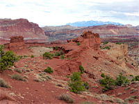
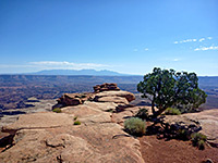
The edge of the plateau is in view from the second minor summit, not far ahead - the Murphy Point Trail, its course now marked by cairns, crosses slickrock and jumbled boulders of Kayenta sandstone to the viewpoint on the rim, though a better overlook is 1,000 feet away on the far western tip, since much more of the land to the north is visible. In the foreground below, the view extends from the red cliffs at the edge of Steer Mesa, across Holeman Spring Basin, Candlestick Tower (a tall Wingate sandstone pinnacle at the end of a thin ridge), Soda Springs Basin, Murphy Hogback and Murphy Basin, to Junction Butte and the west edge of Grand View Point. About 10 miles of the White Rim Road can be seen, snaking around side canyons and ridges.
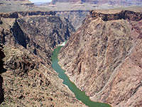
The Green River is quite prominent, especially at Turks Head, where it flows round a big U-bend. Further west, most of the land is part of Glen Canyon National Recreation Area - a trailless expanse of red rocks, backed by the distant Henry Mountains, while in the south, the panorama includes the Maze and Needles districts of the national park, and the Abajo Mountains. Along with two more nearby overlooks reached by trail (Grand View Point, White Rim), and others on the Island in the Sky, the view from Murphy Point is one of the best in Utah.
Directly below the point, the Murphy Hogback is a narrow, flat-topped ridge of Moenkopi Formation sandstone, forming a westerly extension of the promontory 1,000 feet lower down, and this may be reached by a separate trail that branches off half way, and forms part of a ten mile loop down to the White Rim Road, but the Murphy Point Trail has similar views for a lot less effort. The level, bushy land on the promontory is the southernmost location on the Island open for overnight backcountry use (subject to purchase of a permit for $15), and the mesa edge makes a spectacular place to camp, and watch the setting sun.
Location
Map of the Island in the Sky.
The Trail
The Murphy Point Trail has a rather small and inconspicuous parking area, sometimes muddy, 2.5 miles south of the Upheaval Road junction, at the start of a long disused dirt track. Path/track heads southwest across the plateau, initially over flat, grassy land dotted with opuntia cacti and summer wildflowers, and past an old wooden corral built next to a sandstone knoll - remnant from the times prior to the national park creation (1964), when the Island in the Sky grasslands were used for cattle ranching. The terrain becomes sandier, rockier and more uneven, and the vegetation changes to pinyon/juniper pine, as the path climbs slightly to a ridgetop, descends a little then rises to a second high point, formed of exposed sandstone and whitish earth. Just prior to this, the Murphy Trail forks off to the left, dropping steeply down the cliffs then splitting again - one branch traverses the Murphy Hogback down to the White Rim Road, while the other descends sooner and follows a drainage, reaching the same road 1.3 miles south. Together the loop is 10 miles and involves 1,250 feet of elevation change.
The Viewpoint
The edge of the plateau is in view from the second minor summit, not far ahead - the Murphy Point Trail, its course now marked by cairns, crosses slickrock and jumbled boulders of Kayenta sandstone to the viewpoint on the rim, though a better overlook is 1,000 feet away on the far western tip, since much more of the land to the north is visible. In the foreground below, the view extends from the red cliffs at the edge of Steer Mesa, across Holeman Spring Basin, Candlestick Tower (a tall Wingate sandstone pinnacle at the end of a thin ridge), Soda Springs Basin, Murphy Hogback and Murphy Basin, to Junction Butte and the west edge of Grand View Point. About 10 miles of the White Rim Road can be seen, snaking around side canyons and ridges.
Green River
The Green River is quite prominent, especially at Turks Head, where it flows round a big U-bend. Further west, most of the land is part of Glen Canyon National Recreation Area - a trailless expanse of red rocks, backed by the distant Henry Mountains, while in the south, the panorama includes the Maze and Needles districts of the national park, and the Abajo Mountains. Along with two more nearby overlooks reached by trail (Grand View Point, White Rim), and others on the Island in the Sky, the view from Murphy Point is one of the best in Utah.
Murphy Point Trail - Similar Hikes
All Contents © Copyright The American Southwest | Comments and Questions | Contribute | Affiliate Marketing Disclosure | Site Map


