Loop Trail
The only extended hike in Dead Horse Point State Park; a combination of the East Rim and West Rim trails, visiting four named overlooks, of Shafer Canyon and the Colorado River
Length: 5.5 miles
Elevation change: 160 feet
Difficulty: Easy to moderate; lacks shade
Type: Loop, including 3 short spurs
Usage: Low to medium
Season: Spring and fall are preferred
Trailhead: Parking area at the Neck
Rating (1-5): ★★★★★
Elevation change: 160 feet
Difficulty: Easy to moderate; lacks shade
Type: Loop, including 3 short spurs
Usage: Low to medium
Season: Spring and fall are preferred
Trailhead: Parking area at the Neck
Rating (1-5): ★★★★★
The three main points of interest in Dead Horse Point State Park are the visitor center, the campground and the main viewpoint - Dead Horse Point, which is right at the south end of the road, reached by a very short walk, and visited by hundreds of people each day at popular times of the year. Far fewer see other areas, either the flat, grassy interior or the remaining sections of the plateau rim, which extends several miles to the west, around Shafer Canyon, and to the east, above the Colorado River. Yet along the rim are eight other named overlooks, all reached by trails, some relatively long and used mostly by cyclists, others shorter and for foot travel only.
The southernmost four of these viewpoints may be seen by a 5.5 mile loop trail, which includes three short spurs; a combination of the West Rim Trail to the Meander, Shafer Canyon and Rim overlooks, and the East Rim Trail to Basin Overlook. All of the route is essentially flat, though generally lacking shade so the hike can be quite testing during the heat of summer, despite the gentle terrain. Vegetation includes pinyon and juniper pines, opuntia and echinocereus cacti, yucca, and a limited selection of wildflowers.
The hike can start from the end viewpoint, adding about half a mile to the distance, but the usual parking place is just before at The Neck, the narrowest section of the promontory where the opposing rims are just 100 feet apart. The loop can also begin at the visitor center or the campground.
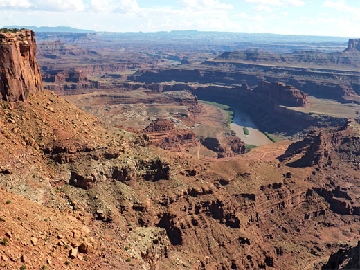
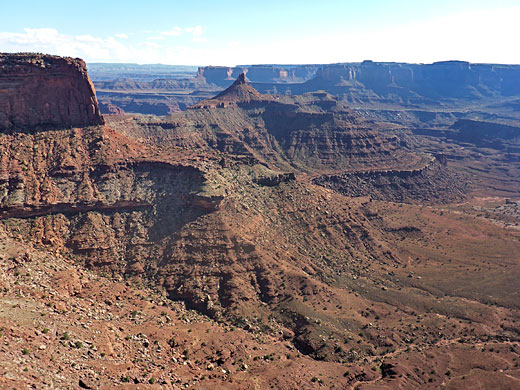
From the Neck, the West Rim Trail starts off along the cliff edge then moves away briefly, curving back to the rim at Meander Overlook, which gives a similar view to the main point, centered on grassy flats either side of a big U-bend along the Colorado River. The path continues, away from the rim again, cutting across the southwestern section of the promontory and bypassing one point, to the junction with a quarter mile spur to Shafer Canyon Overlook, above a narrow, westwards-projecting ridge. This place is directly opposite the South Fork of Shafer Canyon, and the famous, winding trail that links Potash Road with Canyonlands National Park. Part of the river is still in view to the left, and a varied array of cliffs and fins, plus two prominent pinnacles.
Mountain biking, and sunrise photography.
The winding trail proceeds northwards, not so close to the rim, climbing and descending slightly a few times to the next spur, a quarter of a mile to Rim Overlook. The most spectacular view here is southwards, towards the pinnacles; to the north, the valley below (East Fork of Shafer Canyon) is now somewhat narrower and shallower. The plateau near the overlook is largely bare white or pale red rock, dotted with numerous potholes that retain water after rainfall. From the spur junction, the path now runs due east, initially still close to the plateau edge then back towards the center of the promontory, rising slightly and passing a junction with a lesser-used branch to Big Horn Overlook (1.25 miles). After here it meets the campground, following the access road and then the main road, to the visitor center, where another branch heads northeast to Colorado River Overlook, while the East Rim Trail goes south, rising slightly then levelling out.
The rim hereabouts is different to the west - smoother, flatter and containing fewer rocky outcrops. The path moves round to the east, through a group of short, dead trees to the junction with the final spur, to Basin Overlook; this descends an earthen slope and crosses a slickrock flat to the viewpoint. The bright turquoise evaporation ponds from the Potash mine in Shafer Basin are the most colorful feature in the foreground, 2.5 miles away; beyond here are the convoluted, deep red rocks around the Colorado River, with the La Sal Mountains rising in the distance. Some of the river is in view, and the panorama spans over 180 degrees. The fins of the Behind-the-Rocks region are visible to the northeast, and a larger area of formations to the south, centered on Hatch Point. Basin Overlook is a good place from which to observe the sunrise. The loop hike is completed by a 0.7 mile walk southwestwards, back to the Neck.
The southernmost four of these viewpoints may be seen by a 5.5 mile loop trail, which includes three short spurs; a combination of the West Rim Trail to the Meander, Shafer Canyon and Rim overlooks, and the East Rim Trail to Basin Overlook. All of the route is essentially flat, though generally lacking shade so the hike can be quite testing during the heat of summer, despite the gentle terrain. Vegetation includes pinyon and juniper pines, opuntia and echinocereus cacti, yucca, and a limited selection of wildflowers.
The hike can start from the end viewpoint, adding about half a mile to the distance, but the usual parking place is just before at The Neck, the narrowest section of the promontory where the opposing rims are just 100 feet apart. The loop can also begin at the visitor center or the campground.
Meander and Shafer Canyon Overlooks
From the Neck, the West Rim Trail starts off along the cliff edge then moves away briefly, curving back to the rim at Meander Overlook, which gives a similar view to the main point, centered on grassy flats either side of a big U-bend along the Colorado River. The path continues, away from the rim again, cutting across the southwestern section of the promontory and bypassing one point, to the junction with a quarter mile spur to Shafer Canyon Overlook, above a narrow, westwards-projecting ridge. This place is directly opposite the South Fork of Shafer Canyon, and the famous, winding trail that links Potash Road with Canyonlands National Park. Part of the river is still in view to the left, and a varied array of cliffs and fins, plus two prominent pinnacles.
Tours of Dead Horse Point
Mountain biking, and sunrise photography.
Rim Overlook
The winding trail proceeds northwards, not so close to the rim, climbing and descending slightly a few times to the next spur, a quarter of a mile to Rim Overlook. The most spectacular view here is southwards, towards the pinnacles; to the north, the valley below (East Fork of Shafer Canyon) is now somewhat narrower and shallower. The plateau near the overlook is largely bare white or pale red rock, dotted with numerous potholes that retain water after rainfall. From the spur junction, the path now runs due east, initially still close to the plateau edge then back towards the center of the promontory, rising slightly and passing a junction with a lesser-used branch to Big Horn Overlook (1.25 miles). After here it meets the campground, following the access road and then the main road, to the visitor center, where another branch heads northeast to Colorado River Overlook, while the East Rim Trail goes south, rising slightly then levelling out.
The East Rim
The rim hereabouts is different to the west - smoother, flatter and containing fewer rocky outcrops. The path moves round to the east, through a group of short, dead trees to the junction with the final spur, to Basin Overlook; this descends an earthen slope and crosses a slickrock flat to the viewpoint. The bright turquoise evaporation ponds from the Potash mine in Shafer Basin are the most colorful feature in the foreground, 2.5 miles away; beyond here are the convoluted, deep red rocks around the Colorado River, with the La Sal Mountains rising in the distance. Some of the river is in view, and the panorama spans over 180 degrees. The fins of the Behind-the-Rocks region are visible to the northeast, and a larger area of formations to the south, centered on Hatch Point. Basin Overlook is a good place from which to observe the sunrise. The loop hike is completed by a 0.7 mile walk southwestwards, back to the Neck.
Loop Trail - Similar Hikes
All Contents © Copyright The American Southwest | Comments and Questions | Contribute | Affiliate Marketing Disclosure | Site Map


