Ferron Box Rock Art
Pictographs on the cliffs of the Ferron Box, along Ferron Creek, and petroglyphs in open terrain a little way south. Along the west edge of the San Rafael Swell, reached by unpaved roads
Length: 2.4 miles, or 0.3 miles from the closest 4WD parking area
Elevation change: 400 feet, or 100 feet
Difficulty: Moderate
Type: One way
Usage: Low
Season: All year, but not during wet or icy weather
Trailhead: Along Dutch Flat Road, 8 miles east of Ferron. 4WD vehicles can drive to the rim of the Box
Rating (1-5): ★★★★★
Elevation change: 400 feet, or 100 feet
Difficulty: Moderate
Type: One way
Usage: Low
Season: All year, but not during wet or icy weather
Trailhead: Along Dutch Flat Road, 8 miles east of Ferron. 4WD vehicles can drive to the rim of the Box
Rating (1-5): ★★★★★

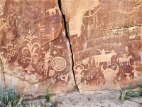
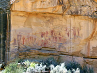
Although many of the panels are little-known and not often visited, the San Rafael Swell is one of the best places in Utah to see rock art, in particular petroglyphs, most of which are in the Barrier Canyon Style, between 1,000 and 4,000 years old, characterised by large humanoid figures, often limbless, exaggerated in scale, frequently in conjunction with plant and animal effigies.
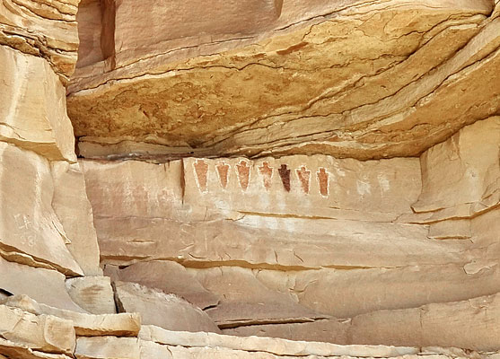
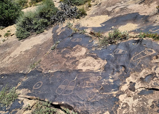
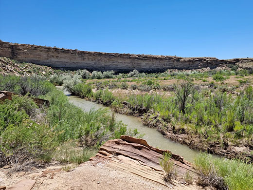
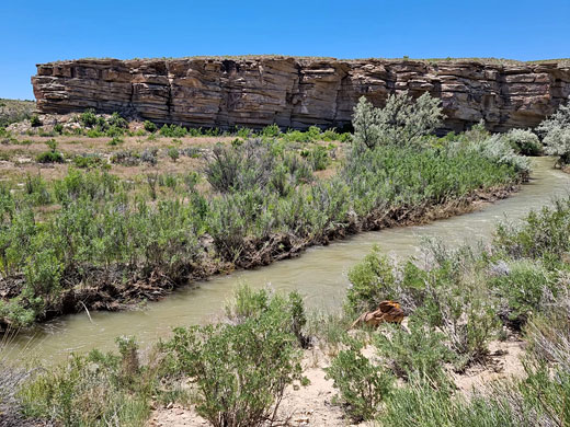
One such location, on the west side of the Swell, is the Ferron Box, a short, cliff-bound section of the shallow canyon of Ferron Creek, 8 miles upstream of its confluence with the San Rafael River. The cliffs, formed of the buff-colored Ferron Sandstone Member of the Dakota Shale, are thin-layered, up to 100 feet tall, and are adorned with several groups of the pictographs, while half a mile south, in open terrain, are some petroglyphs, on a flat outcrop also near the creek, with several dozen designs including a number of pairs of moccasins, or sandals.
This rather remote area is reached by driving 4.2 miles on good-quality unpaved tracks then a hike of 2.4 miles, though 4WD vehicles can approach much closer, to the rim of the cliffs above the Box.
Guidelines for visiting archaeological sites
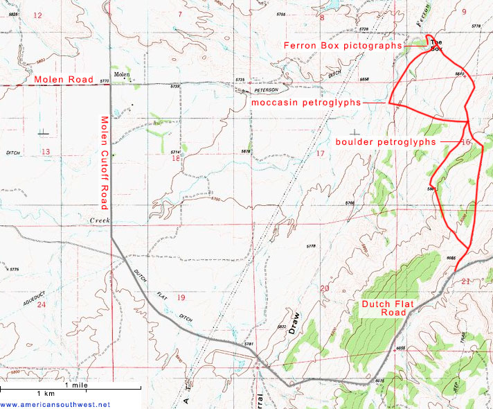
The approach to Ferron Box is from the west - eastwards along Molen Road from Ferron, south on Molen Cutoff Road (S 2400E), which becomes unpaved after a mile, then forking left along Dutch Flat Road (705), which after 1.9 miles reaches a crossroads, with Ferron Reef Road. This is the 2WD parking place, on a verge just beyond; 4WD vehicles can continue, turning north, climbing to the top of a ridge, straight on after a four-way junction, then bearing left soon after, now descending steadily, and reaching another four-way junction, after 1.2 miles. From here, the westwards track, rougher than before, descends a series of ledges and approaches the Ferron Creek after 0.6 miles, near the moccasin petroglyphs, at which point it turns north and arrives the rim of the cliffs of the Box in another 0.5 miles, a location also reachable by continuing straight on at the preceding four-way junction.
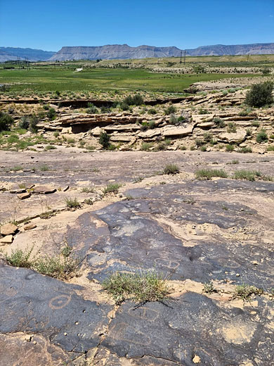
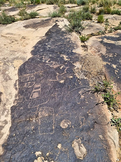
Besides the two main rock art areas are several other sites, the first being a set of petroglyphs, most rather faded, on boulders, 800 feet south of the second four-way junction, just south of the minor promontory. 0.6 miles west, the moccasin or sandal petroglyphs are carved into the dark surface of a flat sandstone outcrop, close to the rim of the low cliffs above the creek; 100 feet northwest of the point where the track curves from east-west to north-south.
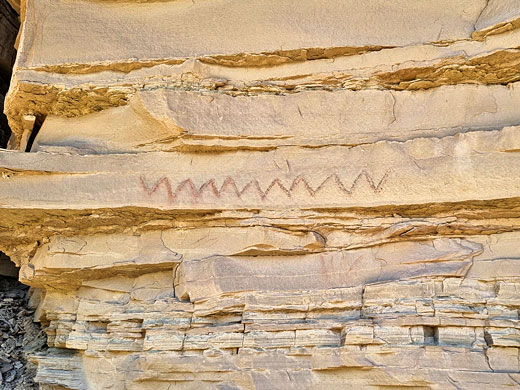
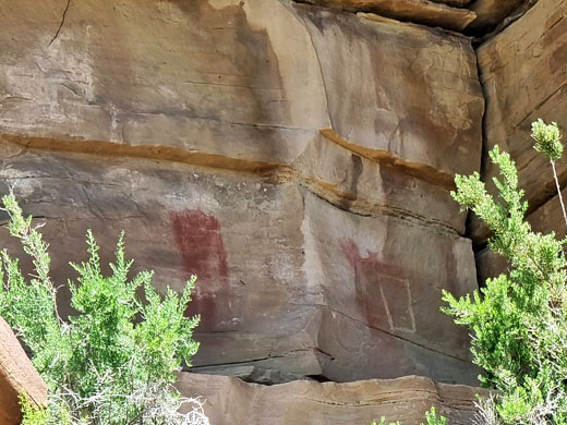
The main area of the rock art, the pictographs (plus a few petroglyphs), are spread out over 500 feet on the southwest-facing cliffs of the Box. The two access routes meet near the edge of the cliffs, opposite a U-bend along the creek; the walking route is 800 feet along the rim, northwestwards, until the cliffs recede, down a slope to the canyon floor, and back south along the base of the cliffs, looking for the various panels. Two main groupings are the Segregation Panel, a line of limbless figures, and the Rainbow Panel, some reddish figures beneath three arcs. Most of the pictographs are high up and not easy to reach, only viewable from a distance. More reddish designs are visible on the opposite side of the creek, but they are on private property.
One such location, on the west side of the Swell, is the Ferron Box, a short, cliff-bound section of the shallow canyon of Ferron Creek, 8 miles upstream of its confluence with the San Rafael River. The cliffs, formed of the buff-colored Ferron Sandstone Member of the Dakota Shale, are thin-layered, up to 100 feet tall, and are adorned with several groups of the pictographs, while half a mile south, in open terrain, are some petroglyphs, on a flat outcrop also near the creek, with several dozen designs including a number of pairs of moccasins, or sandals.
This rather remote area is reached by driving 4.2 miles on good-quality unpaved tracks then a hike of 2.4 miles, though 4WD vehicles can approach much closer, to the rim of the cliffs above the Box.
Guidelines for visiting archaeological sites
Ferron Box Access
The approach to Ferron Box is from the west - eastwards along Molen Road from Ferron, south on Molen Cutoff Road (S 2400E), which becomes unpaved after a mile, then forking left along Dutch Flat Road (705), which after 1.9 miles reaches a crossroads, with Ferron Reef Road. This is the 2WD parking place, on a verge just beyond; 4WD vehicles can continue, turning north, climbing to the top of a ridge, straight on after a four-way junction, then bearing left soon after, now descending steadily, and reaching another four-way junction, after 1.2 miles. From here, the westwards track, rougher than before, descends a series of ledges and approaches the Ferron Creek after 0.6 miles, near the moccasin petroglyphs, at which point it turns north and arrives the rim of the cliffs of the Box in another 0.5 miles, a location also reachable by continuing straight on at the preceding four-way junction.
Petroglyphs
Besides the two main rock art areas are several other sites, the first being a set of petroglyphs, most rather faded, on boulders, 800 feet south of the second four-way junction, just south of the minor promontory. 0.6 miles west, the moccasin or sandal petroglyphs are carved into the dark surface of a flat sandstone outcrop, close to the rim of the low cliffs above the creek; 100 feet northwest of the point where the track curves from east-west to north-south.
Pictographs
The main area of the rock art, the pictographs (plus a few petroglyphs), are spread out over 500 feet on the southwest-facing cliffs of the Box. The two access routes meet near the edge of the cliffs, opposite a U-bend along the creek; the walking route is 800 feet along the rim, northwestwards, until the cliffs recede, down a slope to the canyon floor, and back south along the base of the cliffs, looking for the various panels. Two main groupings are the Segregation Panel, a line of limbless figures, and the Rainbow Panel, some reddish figures beneath three arcs. Most of the pictographs are high up and not easy to reach, only viewable from a distance. More reddish designs are visible on the opposite side of the creek, but they are on private property.
Topo Map of the Ferron Box Rock Art
Ferron Box Rock Art - Similar Hikes


All Contents © Copyright The American Southwest | Comments and Questions | Contribute | Affiliate Marketing Disclosure | Site Map