Chinle Trail
Long but mostly level path in Zion's low elevation southwest corner - over two drainages, past many pieces of petrified wood and within sight of high red cliffs, ending at the permanent stream of Coalpits Wash
Length: 3.3 miles to Huber Wash, 5.2 miles to Scroggins Wash, 8 miles to Coalpits Wash
Elevation change: 420 feet to Huber Wash, 650 feet to Scroggins Wash, then more level
Difficulty: Moderate - long, and often hot, though not steep
Type: One way, or part of a loop down one of the three washes
Usage: Low
Season: Fall, winter, spring - hot in summer
Trailhead: Along Anasazi Way, just off Hwy 9
Rating (1-5): ★★★★★
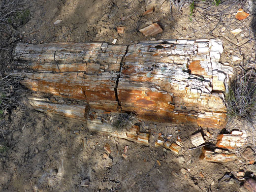
Named after the most distinctive of the adjacent sedimentary layers (the Chinle Formation), the Chinle Trail crosses part of the southwest corner of Zion National Park, the section lowest in elevation, and much is over flat, exposed ground, largely lacking any shade, so the hike is best avoided during the summer months. The route was previously known as the Petrified Forest Trail since, as is often the case with outcrops of the Chinle Formation, many pieces of fossilized wood are visible, including wide trunks up to 30 feet long; not brightly colored like specimens from the more famous Southwest locations, but still pretty enough for many of the smaller fragments to have been stolen over the years.
The wood is found along the middle third of the trail, on a partly wooded mesa between two drainages - Huber Wash, reached after 3.3 miles, and Scroggins Wash, after 5.2 miles. The former is a tributary of the Virgin River, while the latter is a branch of a third drainage, Coalpits Wash, which the path meets at its end point, after 8 miles. Coalpits contains a permanent stream, but the other two are mostly dry, and all three have recognized hiking routes, thus allowing for various loop hikes; the first two are also possible destinations for shorter, one-way hikes, on the Chinle Trail.
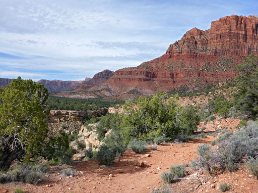
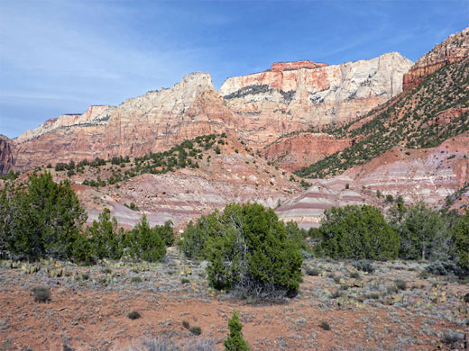
Besides the petrified wood, and the three drainages, the path is also notable for abundant wildflowers in spring, and for the grand vista of some of the famous formations around the mouth of Zion Canyon, here seen from the less-often-viewed west side - Mount Kinesava, West Temple, The Sundial and part of Towers of the Virgin. These cliffs are always in sight to the east, above banded hills of the Chinle Formation, while the views along the latter reaches of the trail extend north towards Cougar Mountain. The majority of the hike is across wide benches of the more resistant Moenkopi Formation, variously covered in grass, bushes and small trees.
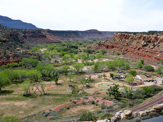
The hike is not signposted from the main road (Hwy 9), and is much less busy than many other Zion trails, in part due to the lack of any spectacular central attraction, though at cooler times it still sees several dozen people each day. The trailhead is on the southwest side of Springdale at the edge of a recent housing development along Anasazi Way, reached by driving steeply up this road for 450 feet, then equally steeply down a track on the right, descending to a large, gravel parking area. The road is signed as private, but the public are allowed to use just the lower end. No entrance or parking fees are required.
The Chinle Trail once began at the Zion National Park boundary, at the end of an unpaved track one mile from the highway, but the intermediate land is now part of the housing development, and is accessible to foot traffic only, though not along the road, instead on a winding path that first climbs the stony hillside above the parking lot, then bends back and crosses Anasazi Way, rounding the rim of a drainage close to several houses, whilst giving fine views of the wooded Virgin River valley, 150 feet below. The path leads up the drainage once it becomes shallow, crosses the road a second time and continues along the streamway briefly before rising to the sandy, treeless land to the west, and following the old track to a fence and gate that mark the Zion National Park boundary, beside a corral - the original start point of the trail.
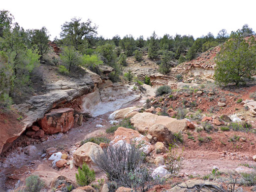
Past the fence, the path continues over similarly flat and open terrain, at the east side of Rockville Bench, heading northwest over a few minor streamways while gaining height very gradually and moving along the base of the cliffs on the south side of Mount Kinesava. The first outcrops of the Chinle Formation are visible at the base of the taller cliffs. The ground falls away abruptly at the edge of the bench, the rim of the first of the three major drainages, Huber Wash, at this point about 200 feet deep and largely sheer-walled. The canyon rim slopes gently down to the north as the streambed quickly gains height, so the path soon arrives at floor level, crossing two forks of the dry wash and ascending slightly to a party wooded area, the start of the petrified wood region.
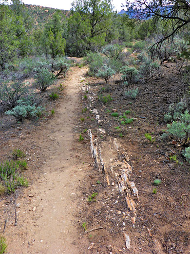
Several long petrified trunks run beside or across the path, mostly well buried, and numerous smaller pieces are scattered all around. The wood is colored white, light brown or pale yellow, and the exposed parts seem generally flaky and brittle. The trees become briefly larger, then fade away, and the more open surroundings allow the best views of the tall cliffs to the east, again above lengthy outcrops of the banded Chinle strata. The path crosses a small drainage then climbs over a saddle, past a sign to a primitive camping site, and descends towards Scroggins Wash, which like Huber is deep and somewhat enclosed downstream but the upper reaches are shallow, and after descending 200 feet while staying relatively far from the canyon, the trail crosses the wash, here lined by a low band of white rocks.
The route continues across another fork of Scroggins Wash and starts a moderate climb up the far side, through rockier terrain, then back into the woods; over two more tributaries and alongside another, surrounded by colorful Chinle slopes. Near here a lesser path branches off southeastwards, descending steeply to the floor of the wash - this is the Old Scroggins Stock Trail, and links with the route downstream to the confluence with Coalpits Wash. The last mile of the Chinle Trail is west and then north, across less vegetated flats, over a minor ridge and round several gullies above the final drainage, Coalpits Wash, descending to a wide section of the streambed, near which are several good locations for primitive camping. This is the end of the Chinle Trail, though continuation hikes are possible both downstream - through an enclosed, boulder-filled section and a wider lower part to a trailhead along Hwy 9 (3.6 miles), or upstream. In this direction, the wash can be followed for another 5 miles or more; it gradually narrows and becomes more overgrown, and in the upper end flows through some pools, waterfalls and shallow slots.
The wood is found along the middle third of the trail, on a partly wooded mesa between two drainages - Huber Wash, reached after 3.3 miles, and Scroggins Wash, after 5.2 miles. The former is a tributary of the Virgin River, while the latter is a branch of a third drainage, Coalpits Wash, which the path meets at its end point, after 8 miles. Coalpits contains a permanent stream, but the other two are mostly dry, and all three have recognized hiking routes, thus allowing for various loop hikes; the first two are also possible destinations for shorter, one-way hikes, on the Chinle Trail.
Besides the petrified wood, and the three drainages, the path is also notable for abundant wildflowers in spring, and for the grand vista of some of the famous formations around the mouth of Zion Canyon, here seen from the less-often-viewed west side - Mount Kinesava, West Temple, The Sundial and part of Towers of the Virgin. These cliffs are always in sight to the east, above banded hills of the Chinle Formation, while the views along the latter reaches of the trail extend north towards Cougar Mountain. The majority of the hike is across wide benches of the more resistant Moenkopi Formation, variously covered in grass, bushes and small trees.
Chinle Trailhead
The hike is not signposted from the main road (Hwy 9), and is much less busy than many other Zion trails, in part due to the lack of any spectacular central attraction, though at cooler times it still sees several dozen people each day. The trailhead is on the southwest side of Springdale at the edge of a recent housing development along Anasazi Way, reached by driving steeply up this road for 450 feet, then equally steeply down a track on the right, descending to a large, gravel parking area. The road is signed as private, but the public are allowed to use just the lower end. No entrance or parking fees are required.
Path to the Park Boundary
The Chinle Trail once began at the Zion National Park boundary, at the end of an unpaved track one mile from the highway, but the intermediate land is now part of the housing development, and is accessible to foot traffic only, though not along the road, instead on a winding path that first climbs the stony hillside above the parking lot, then bends back and crosses Anasazi Way, rounding the rim of a drainage close to several houses, whilst giving fine views of the wooded Virgin River valley, 150 feet below. The path leads up the drainage once it becomes shallow, crosses the road a second time and continues along the streamway briefly before rising to the sandy, treeless land to the west, and following the old track to a fence and gate that mark the Zion National Park boundary, beside a corral - the original start point of the trail.
Huber Wash
Past the fence, the path continues over similarly flat and open terrain, at the east side of Rockville Bench, heading northwest over a few minor streamways while gaining height very gradually and moving along the base of the cliffs on the south side of Mount Kinesava. The first outcrops of the Chinle Formation are visible at the base of the taller cliffs. The ground falls away abruptly at the edge of the bench, the rim of the first of the three major drainages, Huber Wash, at this point about 200 feet deep and largely sheer-walled. The canyon rim slopes gently down to the north as the streambed quickly gains height, so the path soon arrives at floor level, crossing two forks of the dry wash and ascending slightly to a party wooded area, the start of the petrified wood region.
Scroggins Wash
Several long petrified trunks run beside or across the path, mostly well buried, and numerous smaller pieces are scattered all around. The wood is colored white, light brown or pale yellow, and the exposed parts seem generally flaky and brittle. The trees become briefly larger, then fade away, and the more open surroundings allow the best views of the tall cliffs to the east, again above lengthy outcrops of the banded Chinle strata. The path crosses a small drainage then climbs over a saddle, past a sign to a primitive camping site, and descends towards Scroggins Wash, which like Huber is deep and somewhat enclosed downstream but the upper reaches are shallow, and after descending 200 feet while staying relatively far from the canyon, the trail crosses the wash, here lined by a low band of white rocks.
Coalpits Wash
The route continues across another fork of Scroggins Wash and starts a moderate climb up the far side, through rockier terrain, then back into the woods; over two more tributaries and alongside another, surrounded by colorful Chinle slopes. Near here a lesser path branches off southeastwards, descending steeply to the floor of the wash - this is the Old Scroggins Stock Trail, and links with the route downstream to the confluence with Coalpits Wash. The last mile of the Chinle Trail is west and then north, across less vegetated flats, over a minor ridge and round several gullies above the final drainage, Coalpits Wash, descending to a wide section of the streambed, near which are several good locations for primitive camping. This is the end of the Chinle Trail, though continuation hikes are possible both downstream - through an enclosed, boulder-filled section and a wider lower part to a trailhead along Hwy 9 (3.6 miles), or upstream. In this direction, the wash can be followed for another 5 miles or more; it gradually narrows and becomes more overgrown, and in the upper end flows through some pools, waterfalls and shallow slots.
Chinle Trail - Similar Hikes
All Contents © Copyright The American Southwest | Comments and Questions | Contribute | Affiliate Marketing Disclosure | Site Map


